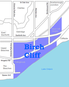
Birch Cliff
| Birch Cliff | |
|---|---|
| Neighbourhood | |
|
A group of houses in the Birch Cliff neighborhood | |
 Vicinity | |
 Location within Toronto | |
| Coordinates: 43°41′15″N 79°16′10″W / 43.68750°N 79.26944°WCoordinates: 43°41′15″N 79°16′10″W / 43.68750°N 79.26944°W | |
| Country |
|
| Province |
|
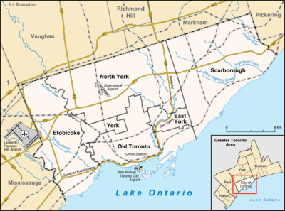
| City |
|
| Community | Scarborough |
| Changed Municipality |
1998 Toronto from |
| Government | |
| • MP | Bill Blair (Scarborough Southwest) |
| • MPP | Lorenzo Berardinetti (Scarborough Southwest) |
| • Councillor | Gary Crawford (Ward 36 Scarborough Southwest) |

Birch Cliff is a neighbourhood in Toronto, Ontario, Canada. It is located in the southwest part of the old city of Scarborough running along shore of Lake Ontario atop the western part of the Scarborough Bluffs. The area was first developed as the home of the Toronto Hunt Club in 1895 when the region was still mostly farms and woodland. Around the club and number of cottages were erected, and one of these was named "Birch Cliff." This name was also adopted by the local post office, and became the name for the neighbourhood.
As the Beaches neighbourhood was built to the west, the region became the first part of Scarborough to be developed as a suburb to the city of Toronto during the 1920s. Unlike the rest of Scarborough, which was developed after the Second World War as automotive based suburbs, Birch Cliff began as a streetcar suburb. With a TTC streetcar line running along Kingston Road to Birchmount Road. As the most populated part of the borough, Scarborough's municipal council met in a building on Kingston Road beginning in 1922. Kingston Road became a busy shopping district.
Streetcar service east of Victoria Park ended in 1954[1] but during the post-World War II boom Kingston Road become a major thoroughfare for those living further east in the newer suburbs. Most of the shops closed. The area by the lake and the ravines remained a wealthy residential district, while further north is a more middle class portion of Scarborough. This area further north is sometimes referred to as Birch Cliff Heights. The westernmost portion of the neighbourhood, west of the Hunt Club, is known as Fallingbrook. It is closely linked to the Beaches.
Birch Cliff has a large Irish population. About one-third of Birch Cliff residents are of Irish origin.[2][3]

Quarry Lands
A notable section of the neighbourhood is the former Birch Cliff Quarry. This area is a former quarry that was first used as a quarry by the Toronto Brick Company. It covers a large area south of the railroad tracks, north of Gerrard, and east of Victoria Park. From 1954 to 1960 the old quarry was used as a landfill. In 1960 the landfill was shut down and the site was sold to a development company. At the time the Scarborough Expressway was planned to parallel the rail line, and the site would have thus been next to a major interchange. It was thus zoned for high density apartment buildings with 1,450 units. The plan was a tower in a park scheme similar to what was built to the north at Crescent Town. The expense of cleaning up the former landfill delayed to project, and in the interim civic activism stopped the Scarborough Expressway. Modern Jane Jacobs new urbanism also firmly rejects such suburban tower plans, but the area retains the original zoning and under Ontario Municipal Board the city is not allowed to revoke such a zoning.
As of November 6, 2012, the Ontario Municipal Board has approved the "tower in the park" style development, to the remorse of many living in the community.[4]
Landmarks
- Birchcliff Public School
- Toronto Hunt Club
- Rosetta McClain Gardens
- Birchmount Park Collegiate Institute
- Neil McNeil High School
- St. Nicholas Anglican Church
- Birchcliff Bluffs United Church
- R.C. Harris Filtration Plant
References
- ↑ "Remembering Birchmount Loop - Transit Toronto - Content". Transit Toronto. 2012-01-08. Retrieved 2012-05-28.
- ↑ http://www12.statcan.gc.ca/nhs-enm/2011/dp-pd/prof/details/page.cfm?Lang=E&Geo1=CT&Code1=1322&Data=Count&SearchText=5350338.00&SearchType=Begins&SearchPR=01&A1=All&B1=All&Custom=&TABID=3
- ↑ http://www12.statcan.gc.ca/nhs-enm/2011/dp-pd/prof/details/page.cfm?Lang=E&Geo1=CT&Code1=1323&Data=Count&SearchText=5350339.00&SearchType=Begins&SearchPR=01&A1=All&B1=All&Custom=&TABID=3
- ↑ Spencer, Robert. "Years of Citizen Concerns Down the Drain" (PDF). Retrieved 26 November 2012.
 |
Oakridge | | ||
| Upper Beaches (Toronto) | |
Cliffside | ||
| ||||
| | ||||
| Lake Ontario |