Queen Street West
| |||||||
|---|---|---|---|---|---|---|---|
| Route information | |||||||
| Maintained by City of Toronto | |||||||
| Length: | 5.6 km[1] (3.5 mi) | ||||||
| Existed: |
1793 (as Lot St.) 1851 (renamed Queen St.) – present | ||||||
| Major junctions | |||||||
| West end: |
Roncesvalles Avenue King Street | ||||||
|
Dufferin Street University Avenue | |||||||
| East end: | Yonge Street | ||||||
| Highway system | |||||||
| |||||||

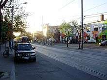
Queen Street West describes both the western branch of Queen Street, a major east-west thoroughfare, and a series of neighbourhoods or commercial districts, situated west of Yonge Street in downtown Toronto, Ontario, Canada. Queen Street begins in the west at the intersection of King Street, The Queensway, and Roncesvalles Avenue. It extends eastward in a straight line to Yonge Street where it becomes Queen Street East; eastbound Queen TTC streetcars loop at Neville Park Boulevard near Queen Street East and Victoria Park Avenue in The Beaches neighbourhood.
Queen Street was the cartographical baseline for the original east-west avenues of Toronto's grid pattern of major streets. The western end of Queen (sometimes simply referred to as "Queen West") is now best known as a centre for Canadian broadcasting, music, fashion, performance, and the visual arts. Over the past twenty-five years, Queen West has become an international arts centre, and a major tourist attraction in Toronto.
History
Since the original survey in 1793 by Sir Alexander Aitkin, commissioned by Lieutenant Governor John Graves Simcoe, Queen Street has had many names. For its first sixty years, many sections were referred to as Lot Street. The first park lots laid out in the new city of York (which would be renamed Toronto in 1834) were given to loyal officials who were willing to give up the amenities of modern cities such as Kingston to take up residence in the forests north of Lot Street. These 40 hectares (99 acres) lots were placed along the south side of the first east–west road laid in York, Lot Street.[2] In 1837 Lot Street was renamed in honour of Queen Victoria.[3]
"Queen West" is local vernacular which generally refers to the collection of neighbourhoods that have developed along and around the thoroughfare. Many of these were originally ethnically-based neighbourhoods. The earliest example from the mid-19th century was Claretown, an Irish immigrant enclave in the area of Queen Street West and Bathurst Street. From the 1890s to the 1930s, Jewish immigrants coalesced in the neighbourhood known as "the Ward", for which Queen Street between Yonge and University served as the southern boundary. The intersection of Queen and Bay Streets also served as the southern end of a thriving Chinatown in the 1930s. From the 1920s to the 1950s, the area was also the heart of Toronto's Polish and Ukrainian communities. From the 1950s through the 1970s, many immigrants from Portugal settled in the area. Gentrification over the past twenty years has caused most recent immigrants to gradually move to more affordable areas of the city as desirability of the area drives up prices.
Like other gentrified areas of Toronto, the original "Queen West" —the stretch between University Avenue and Spadina Avenue — is now lined with upscale boutiques, chain stores, restaurants, tattoo parlours and hair salons. Perhaps the best-known landmark on this section of Queen West is the broadcast hub at 299 Queen Street West, formerly the headquarters of Citytv and MuchMusic and earlier the site of the Ryerson Press, now housing the broadcast operations of a number of television outlets owned by Bell Media.
Yonge to University


Since the 19th century, Queen Street West at Yonge Street has been one of Toronto's primary shopping destinations. Originally, the Eaton's and Simpson's department stores faced each other across Queen Street, with the rivalry between the two stores at one time as central to Toronto retailing as the Macy's/Gimbel's competition was to New York City's retail history. The pedestrian crosswalk on Queen Street, just to the west of the intersection with Yonge Street, was for years one of the busiest in Canada, as thousands of shoppers a day comparison shopped between Eaton's and Simpson's.
Today, Eaton's is gone, but the Toronto Eaton Centre still remains at the same location, one of Canada's largest office and shopping complexes. Similarly, Simpson's is also gone, but the historic department store building remains on the south side of Queen Street, occupied by the Hudson's Bay and Saks Fifth Avenue stores.
Further west, this stretch of Queen Street is dominated by institutional and cultural buildings such as Old City Hall, Toronto City Hall, Osgoode Hall and the Four Seasons Centre.

University to Spadina: Queen West


The area between University and Spadina Avenues was a cultural nexus in the 1980s known for its cheap restaurants, clubs, eclectic mix of musicians and artists and was a haven for the punk rock scene with its famous club kids such as Kinga, Seika, Wanda and a host of others. In the 1960s and into the early 1980s, this stretch of Queen Street West was an ageing commercial strip, known for "greasy spoon" restaurants and inexpensive housing in the area. In the late 1970s and 1980s, the area was transformed by local students, including those of the nearby Ontario College of Art & Design, and the area developed an active music scene which was one of the dominant centres of Canadian music in its era.
The late 1980s, saw the relocation of CityTV to 299 Queen Street West which gentrified the area almost overnight. A more mainstream culture soon attracted other artists, wider audiences, and wealthier businesses to the area. Small independent businesses started to move further west on Queen Street West past Spadina Avenue and Bathurst Street for the cheaper rent, an area at the time which was desolate after working hours. The push continued into the late mid and late 2000's and into Parkdale until that area also became associated with trendy businesses, and now condos.
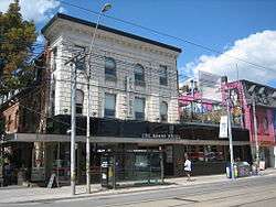
By the mid 1990s with the opening of mainstream stores such as Le Chateau, probably the first chain store on the strip, the name "Queen Street" became synonymous with the such as "trendy", "hip", and "cool". While original businesses such as the Cameron, the Horseshoe Tavern and The Rivoli have remained and changed little, the strip is now cluttered with mid and higher end international chain stores such as H&M and Zara, the antithesis of what the area was about in the 1970s and 1980s.
The broadcast hub at 299 Queen Street West (formerly called the CHUM-City Building), housing a number of CTVglobemedia's television operations, is located at the corner of Queen and John Streets in this area. By the mid 1990s MuchMusic become associated with Queen Street's culture; the station's VJs have often broadcast their segments live from outside the building, and programs such as Electric Circus and the MuchMusic Video Awards have regularly taken place on the street.
In 2014, Vogue Magazine ranked the neighbourhood second in their compilation of the world's top 15 hippest neighbourhoods, being beat out only by Shimokitazawa, Tokyo
A movement by local citizens to rename the area "Soho" after a side-street in the area has never been taken seriously by the municipal government.
St. Patrick's Market, at 238 Queen Street West, was founded in the late 1830s. The current building dates from 1912.
Spadina to Trinity Bellwoods Park

From Spadina to Bathurst, Queen Street is lined with street-level retail, with upper level apartments. Bates and Dodds, Toronto's oldest operating funeral home is at 931 Queen St. West, across from Trinity Bellwoods Park and has been in the same location since 1884. As rents rose, most artists began moving westward to this section of Queen. In the early 1990s, the newly vogue area became associated with nightclubs such as the Bovine Sex Club and several antique shops.
Occupying the same area, between Spadina Avenue and Trinity Bellwoods Park south of Queen Street, is Toronto's Fashion District. In the later 1990s, high-priced clothing stores opened in the same area as the gentrification of the district continued. In the 2000s, the changing character of Queen Street West gave rise to concerns in some quarters over the pace and implications of gentrification.[4]
On February 20, 2008, a large fire destroyed several buildings on the south side of the street, between Bathurst and Portland Streets. The block had been declared a heritage conservation district by the city only the year before. Toronto Fire Services' "active incidents" website reported the fire as six-alarm intensity, with over 14 separate units dispatched to the scene throughout the day. Several neighbourhood businesses and apartments were destroyed in the blaze.[5][6][7] In some cases, the destruction caused by the fire gave rise to additional angst over the changing character of Queen Street West and the potential nature of the new development that would eventually replace the burned buildings.[8]
Bathurst Street to Gladstone Avenue: West Queen Street West (the Art and Design District)
Between Bathurst Street and Gladstone Avenue is West Queen Street West, also known as the Art and Design District. For this two kilometre stretch, nearly every storefront on the north side is either a gallery, bar, or nightclub (the south side of the street is largely taken up by the buildings and grounds of the former Queen Street Mental Health Centre, now part of CAMH), a combination that has led to the district being named one of the coolest neighborhoods in the world both in 2015 and 2016.[9][10] The Stephen Bulger Gallery, founded in 1994, is also located on Queen West, as is the Museum of Contemporary Canadian Art (MOCCA), which relocated to the area in 2005. The future of the MOCCA in this area is uncertain: in 2013, the developer Urbancorp applied to demolish the MOCCA and the adjacent buildings housing the Edward Day and Clint Roenisch gallery and replace them with the nine storey "MOCCA Condo".[11]
Another cause of this gallery conglomeration was the conversion of a former police building (Art-Deco building was a police station last used as Metro Toronto Police 6 Division built in 1931 and closed in the 1990s) into Gallery 1313, with extensive financial assistance by the city. The large amount of gallery space, including such galleries as Loop and Fly, allowed Toronto artists of all levels of ability to show their work at a low cost. Unlike the boutique-oriented storefronts of the eastern portion of the street, the Gallery District contains an abundance of space available for special events. The Camera Bar—originally established by film director and producer Atom Egoyan—is now operated by the Stephen Bulger Gallery as a rental space that offers a bar and film/video screening venue.[12]
West Queen Street West has undergone rapid transformation in the past couple of years. Rents have increased dramatically and many galleries have left. Recent departures include Sis Boom Bah, Luft Gallery, Burston Gallery and Brackett Gallery. At the same time as galleries have closed, many new bars have opened. Many attribute this sudden shift to the development spearheaded by the Drake Hotel, a former flophouse recently renovated and converted to a boutique hotel at a cost of $6 million.
The Gladstone Hotel is one of a few pre-existing businesses in the area that has been able to capitalize on the recent boom. This grand old railroad-era hotel had over the years fallen into disrepair and maintained itself by renting boarding-house style accommodation. The tavern on the first floor is now home to a weekly "Art Bar", where locals from the arts community converge to socialize. In 2005, it underwent a major renovation spearheaded by the Zeidler family.
In 2013, Artscape Youngplace opened at 180 Shaw Street, just north of Queen Street West, after a major renovation and community consultation process. Artscape’s $17 million transformation of the building, the former Shaw Street School, was completed just before the centenary of its construction in 1914. Artscape Youngplace is a 75,000 sq. ft. centre for creative collaboration housing a diverse mix of creators working in a variety of disciplines, as well as arts, community and social mission organizations. Owners and/or tenants include the Koffler Centre of the Arts and Koffler Gallery, Luminato Festival, Centre for Indigenous Theatre, Inter-Galactic Arts Co-op, College-Montrose Children's Place, Paperhouse Studio, Red Pepper Spectacle Arts, SKETCH, Small World Music Society, Typology Projects, The Developing Tank, and artists Barbara Astman, Eve Egoyan, Heather Nichol, Shabnam K. Ghazi, and Vid Ingelevics.
The Queen West Art Crawl (QWAC) is an annual three-day festival celebrating the arts on Queen Street West and featuring the artists, arts organizations and businesses on the thoroughfare. It is produced by the not-for-profit Parkdale Liberty Economic Development Corporation.[13]
West Queen West BIA
The businesses on the stretch of Queen West from Bathurst to Gladstone Ave. have organized the West Queen West Business Improvement Area,[14] which is mandated to undertake streetscape improvement projects, organize community events and promote the neighbourhood's unique commercial establishments.
Its vision is to retain the unique character of the West Queen West business community in the midst of renewal and growth, while attracting visitors/tourists to an area known to boast high concentrations of art and culture. The BIA promotes the West Queen West neighbourhood as a distinct destination for residents and tourists.
Dufferin to Roncesvalles: Parkdale
Until November 2010, Dufferin and Queen was a two-legged intersection broken up by the Queen Street Subway (a historic CN railway bridge underpass - first built in 1898) in the 1200 block, but due to major re-construction, this is now a four way intersection. Once past there, Queen Street West makes its way through Parkdale. Parkdale is one of Toronto's oldest neighbourhoods, and a former independent village, and Queen Street is its main commercial strip, with two and three-storey mixed use buildings, retail on the ground-floor and residences above. Many of the buildings date to the 1880s era when Parkdale was an independent village.
There are numerous bars and restaurants along this section. There is also an increasing number of storefront art galleries, part of an increasing number of artists locating in the area. The laneway parallel to Queen on the south side is decorated with murals, and is nicknamed the 'Milky Way.' There is a business improvement association in this area, grouping businesses in the area under the 'Parkdale Village' banner. The Parkdale Library is located at Cowan Avenue, and Masaryk-Cowan Community Centre is located just south of Queen Street on Cowan. Parkdale has a higher proportion of lower-income residents and there are several support agencies located along Queen.
Queen Street subway
Beneath Queen Street West is a little-known urban artifact. In the 1940s, the Toronto Transit Commission proposed to construct, in addition to a rapid-transit subway under Yonge Street, a second tunnel under Queen Street that would allow the PCC streetcars from certain routes to avoid other traffic as they ran through central areas. The Queen subway would run from Trinity Bellwoods Park in the west to Broadview Avenue in the east. This two-line plan was approved by referendum in 1946, but when hoped-for funding from the government of Canada did not materialize, the Queen line was postponed. In the 1960s, the TTC decided that a subway to replace the crowded Bloor Street streetcars would be more valuable, as after the construction of the Yonge line most of the passenger traffic had moved north with the subway. While the Queen line remained on the list of proposals into the 1970s, it was never a priority again.
When the Yonge subway was being constructed in the early 1950s, the shell of an east-west station for the Queen line, sometimes called Lower Queen, was built under its Queen station, and passenger flows within the station were laid out on the assumption that it would eventually be an interchange. In the 1990s, some of the space was reused for a pedestrian passage when the subway station was being made wheelchair-accessible, but the rest of the station shell remains empty to this day.
The 501 Queen streetcar remains one of the TTC's busiest and longest streetcar routes; it runs every six minutes in each direction (traffic permitting). Queen Street West is also served by Osgoode station at University Avenue.
|


See also
References
- ↑ "Google Maps showing the entire length of Queen Street West". Retrieved 2010-04-08.
- ↑ Filey, Mike (1997). Toronto Sketches 5: The Way We Were. Dundurn Press. p. 100.
- ↑ Filey, Mike (July 4, 2010). "Life". Royal twist to street name. Toronto Sun. Sun Media. p. 37.
- ↑ "Fear and hope for Queen West". Spacing Toronto. January 30, 2008. Retrieved 2009-05-25.
- ↑ "Historic Stretch Of Queen West Destroyed By Massive Fire". CityNews. February 20, 2008. Retrieved 2008-02-20.
- ↑ "6-Alarm Fire at Queen & Bathurst". BlogTO.com. February 20, 2008. Retrieved 2008-02-20.
- ↑ "City of Toronto: Toronto Fire Services". City of Toronto. February 20, 2008. Retrieved 2008-02-20.
- ↑ "Queen Street fire reveals city's many layers". The Varsity. February 25, 2008. Retrieved 2009-05-25.
- ↑ Global Street Style Report: Mapping Out the 15 Coolest Neighborhoods in the World, Vogue, retrieved November 17, 2016
- ↑ The 15 Coolest Neighborhoods in the World in 2016, How I Travel, retrieved November 17, 2016
- ↑ http://www.toronto.ca/legdocs/mmis/2013/te/bgrd/backgroundfile-56036.pdf
- ↑ "Camera Bar - Toronto Lounge, Screening Venue, and Gallery". Camera Bar - Toronto Lounge, Screening Venue, and Gallery.
- ↑ Parkdale Liberty Archived April 20, 2008, at the Wayback Machine.
- ↑ "West Queen West Retail".
External links
| Wikimedia Commons has media related to Queen Street, Toronto. |
- A line on a map: Queen Street history
- History of Queen West Documentary
- Transit Toronto Photos and information related to "Lower Queen" station
- Queen West Art Crawl
- West Queen West Business Improvement Area
- Bathurst & Queen Fire
Major roads, highways and streets in Toronto | |||||||||||
|---|---|---|---|---|---|---|---|---|---|---|---|
| North-south |
| ||||||||||
| East-west |
| ||||||||||
| |||||||||||
| |||||||||||
| Queen Street West Queen Street Route Sequence | ||
| Preceded by The Queensway |
Queen Street West |
Succeeded by Queen Street East |
Coordinates: 43°38′59″N 79°23′33″W / 43.649584°N 79.39241°W