Parkdale, Toronto
| Parkdale | |
|---|---|
| Neighbourhood | |
 | |
 Parkdale neighbourhood | |
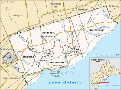 Location within Toronto | |
| Coordinates: 43°38′26″N 79°26′12″W / 43.640454°N 79.436731°WCoordinates: 43°38′26″N 79°26′12″W / 43.640454°N 79.436731°W | |
| Country |
|
| Province |
|
| City |
|
| Established | 1874 Subdivided |
| Incorporated | 1879 (Village) |
| Annexed | 1889 into City of Toronto |
| Government | |
| • City Councillor | Gord Perks |
| • Federal M.P. | Arif Virani |
| • Provincial M.P.P. | Cheri DiNovo |
Parkdale is a neighbourhood and former village in Toronto, Ontario, Canada, west of downtown. The neighbourhood is bounded on the west by Roncesvalles Avenue, on the north by the CP Rail line where it crosses Queen Street and Dundas Street. It is bounded on the east by Dufferin Street from Queen Street south, and on the south by Lake Ontario. The original village incorporated an area north of Queen Street, east of Roncesvalles from Fermanagh east to the main rail lines, today known as part of the Roncesvalles neighbourhood. The village area was roughly one square kilometer in area. The City of Toronto extends the neighbourhood boundaries to the east, south of the CP Rail lines, east to Atlantic Avenue, as far south as the CN Rail lines north of Exhibition Place, the part south of King Street commonly known as the western half of Liberty Village neighbourhood.[1]
Parkdale was founded as an independent settlement within York County in the 1850s. It was incorporated as a village in 1879 and amalgamated with Toronto in 1889. It was an upper income residential area for the first half of the 20th century, with several notable mansions. The area changed dramatically with the building of the Gardiner Expressway in 1955, which resulted in the demolition of the southern section of the neighbourhood and the Sunnyside Amusement Park, and the creation of a barrier between the neighbourhood and the north shore of Lake Ontario. A boom in apartment building construction followed, replacing whole blocks of homes with blocks of apartment buildings. Some of the older large residential buildings remain though many were converted into rooming houses. The demographic composition changed considerably, including a higher proportion of lower income and newcomer families. Today, it is a working-class neighbourhood, with a large percentage of low-income households concentrated in South Parkdale,[2] and an entry point for new immigrants, most recently South Asians and Tibetan.[2] The visible minority population in North Parkdale (between Queen and Landsdowne) has changed overall to include fewer Asian, South Asian and Black residents between the census years 2006-2011 (GNR: 34%). The distribution, of said visible minorities, has changed from being predominantly Black visible minorities to predominantly South Asian (between 2006 and 2011 census).[3]
The area has a vibrant storefront commercial strip along Queen Street West that has seen an increase in restaurants and bars in the 2010s, increasing to the point that planning controls were put in place on the opening of new restaurants and bars from 2012.[4]
Character

Parkdale is primarily a residential area of the city, with semi-detached homes predominating on most side streets. Many of the homes date from the 19th Century and early 20th Century. Around 1900, the area was a well-to-do suburb and many older mansions from around 1900 still exist, often converted to multi-unit buildings. Many of the residential streets have mature trees. Good examples of Victorian housing can still be found on Cowan Avenue and Dunn Avenue, south of King Street. Victorian-era row homes of Georgian Revival style with original gaslights can also be seen on Melbourne Place.[5]
Parkdale has a higher than average amount of rental housing. Several streets, notably Jameson Avenue and Tyndall Avenue have been converted to zones of apartment buildings. The apartment buildings mostly date from the 1950s through the 1970s, and have remained rental buildings while no large condominium projects have been built west of Dufferin Street.
Parkdale's commercial districts are along Queen Street West from Roncesvalles in the west to Dufferin Avenue in the east, and King Street West around Dufferin Street. Queen Street West has a large proportion of restaurants and bars, as well as local shops and art galleries. Commercial space is mostly storefronts oriented toward local customers.
The area has a lower amount of park land per resident compared to other parts of Toronto. Several streets have parkettes built since the 1960s in an initiative to increase the amount of park land in the area.
Demographically, Parkdale is mixed in income and ethnicity. The neighborhood has an above average percentage of renters[6] and that number has increased since 2006 to 2011. The area contains some of the lowest-income persons in the city. Between 2006 and 2011 there was a decrease in the median income of Parkdale by 2.9%.[7] However, in 2011 there was an increase in the amount of people earning within the range of $30,00 to $60,000.[7] The large amount of rental stock is an entry point for immigrants to Toronto. The area has a significant group of musicians and visual artists, who often perform and exhibit locally.
To the south of Parkdale, the area is bordered by transportation uses, including the railway, Gardiner Expressway and Lake Shore Boulevard. South of the transportation corridor, the shoreline is mostly park land, with recreational clubs such as the Argonaut Rowing Club and Boulevard Club (formerly the Parkdale Canoe Club) located on the water.
Main streets

Queen Street West running east-west is the primary commercial street of the neighbourhood. It is four lanes and the buildings are predominantly 2-3 storey buildings, often with apartments on the upper floors. It ends at Roncesvalles, meeting King Street and the Queensway at the 'Sunnyside' intersection. It continues to the east to downtown. The business along Queen have formed a Business Improvement Association under the name of "Parkdale Village." The street has numerous art galleries, restaurants, cafes and convenience stores. The Parkdale branch of the Toronto Public Library is located at Cowan Avenue.
King Street West, running east-west is a major street continuing to the east to Toronto's downtown, ending to the west at Sunnyside. From Roncesvalles east, it curves along the original shoreline, which is about 30 feet (9.1 m) above and 100 yards (91 m) inland from the current shoreline. The south side in that area is open, with views of the Lake. It is predominantly residential, with a commercial section around the intersection with Dufferin Street.
Dufferin Street, running north-south is a major street starting from the CNE to the south, north to Queen Street, where it intersects the railway. The street continues one block to the north and continues north to north of Toronto. It is mixed commercial and residential. South of King along the east side is an old industrial area with loft-type industrial buildings. Construction has been completed to eliminate the Dufferin Street jog at Queen and the railway tracks. Dufferin Street now runs directly north to Wilson Avenue.
Lansdowne Avenue, running north-south from Queen Street north to St. Clair Avenue. It is predominantly a residential street. The former West Toronto Collegiate, now a francophone high school is located at College Street and Lansdowne. The former National Cash Register factory at Dundas Street has been a grocery store since the 1980s.
Jameson Avenue, running north-south from Queen Street south to Lake Shore Boulevard. It is predominantly a residential street of apartment buildings. There are two schools located on Jameson, Parkdale Collegiate, near Queen, and Queen Victoria Public, just south of King Street. It is also a busy thoroughfare on the west side of Toronto, connecting to the Gardiner Expressway and Lake Shore Boulevard.
History


The Village of Parkdale was founded in 1879, but settlement of the area predated its foundation. In 1812, the 240 acres (97 ha) of land bounded from Lot Street (today's Queen Street) on the north, and Jameson on the west and Dufferin Avenue was granted to James Brock, the cousin of Sir Isaac Brock, in lieu of salary. Brock did not occupy or improve the land during his lifetime. After Brock's death in 1830, his widow Lucy Brock sold the lands which became the major part of Parkdale to John Henry Dunn and William Gwynne.[8] The area north of Queen Street was subdivided from the O'Hara Estate, given to Walter O'Hara for military service. Another parcel of land north of Queen was given to James Brock, east of the O'Hara estate, was developed along Brock Avenue and became Brockton Village.
The Parkdale railway station was opened at Queen and Dufferin streets in 1856. In the 1870s, the Grand Trunk Railway built a railway station at Jameson Avenue, on its east-west line. It was named South Parkdale, and the Queen Street station was given the name of North Parkdale station.
A census of residents prior to the founding showed 783 residents of the area, more than enough for the legal requirement of 750 at the time. A local legend is that Gypsies were signed up as local residents to provide enough numbers. Parkdale's status as an independent village was controversial at the time and was opposed by the City of Toronto and the York County councils.
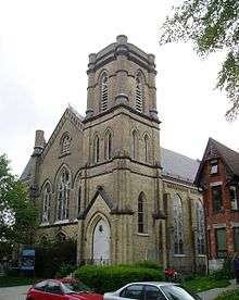
It was purely a residential suburb, home to large Victorian mansions and views of Lake Ontario. The first house of worship in Parkdale, the Anglican Church of St. Mark, was completed on January 20, 1881, on Cowan Ave just south of Queen Street.[9] In 1884, the Village council passed a bylaw to join Toronto, to be annexed by the City of Toronto, as the village was in fact surrounded by the city of Toronto. The act did not take place immediately as the Village's finances were not in order. Liabilities of the village were not clearly stated in the village's financial statements. On October 27, 1888, another vote was held and the annexation was upheld. The village was annexed by the City of Toronto in March 1889. It became "St. Alban's Ward.".[10]
In the 1910s, the South Parkdale station was closed and replaced with Sunnyside railway station. At the time, a cut was made between Dowling and Atlantic streets and the rail lines of the Grand Trunk were moved below street level. The North Parkdale stations were given new signage of "Parkdale", returning to the original name.
'Sunnyside years'
Throughout the first half of the 20th century, Parkdale's desirability stemmed from its proximity to the lake, the Canadian National Exhibition to the south-east and the popular Sunnyside Beach at the foot of Roncesvalles to the west. From 1911 to 1922, the Toronto Harbour Commission improved the lakefront extending the shoreline from the rail line 100 metres (330 ft) south, with a breakwater and boardwalk. As an example, in 1905, the Parkdale Canoe Club (today it's known as the Boulevard Club) opened. When built, it was on a pier extending out into the lake. As part of the infill project, it became situated inland. To the east of the current building, a baseball and lacrosse field existed. It was the site of a popular women's softball league for many years.
Sunnyside Amusement Park was opened in 1922, providing a popular day vacation for Torontonians. Movie theatres were opened, such as the Brighton on Roncesvalles and the Odeon on Queen Street to the east of Roncesvalles. Hotels like the Edgewater at Queen and Roncesvalles were established.
The Palais Royale at the eastern edge of Sunnyside Beach opened in 1922 as a canoe factory and dance hall. Many important big bands played there in the 1930s and the 1940s, and this attracted a large youth patronage. Many war generation Torontonians courted their future partners in this building. The Palais Royale operates today as a special occasion hall and is a favourite venue for bands, including the Rolling Stones, who played a 2002 concert there, and has been the location for live recordings by Sloan and Downchild Blues Band.
1950s-1970s: Gardiner Expressway and urban changes
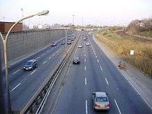
In 1955, the city began work on the Gardiner Expressway, a limited access highway alongside the railway cut. The Sunnyside Amusement Park was demolished, except for the Bathing Pavilion and the Palais Royale hall. The southern section of Parkdale to the west of Dufferin, south of the railway was also demolished. Parkdale was now separated from Lake Ontario and Sunnyside Beach and the expressway effectively halved the amount of usable lakeside parkland. A reorganization of the area's residential streets was also done. Patronage of the beach declined rapidly. Both the Parkdale and Sunnyside train stations closed during the 1970s.
The neighbourhood changed greatly after the highway was completed and the park closed. Population density increased with the building of numerous apartment buildings. Jameson Avenue, which became the conduit to the highway changed from single family homes to a street of apartment buildings, many cheaply built. Nearby, many of the mansions and large houses became makeshift low-rise 'bachelorette' apartment buildings and rooming houses. Several had operated as tourist hotels for visitors to Sunnyside and the CNE. Industrial activity declined along the railways. One former industrial site on West Lodge Avenue became a two-tower apartment complex that has repeatedly been cited by the City for various by-law infractions. Businesses suffered during the transition, with leisure-type businesses compatible with the Park, such as the Brighton and Odeon theatres closing. Along Queen Street, which saw traffic decline substantially, many businesses closed or changed hands.
1970s: Absorption of out-patients
In the mid-1970s, the Government of Ontario decided to release many long-term care mental illness patients from its Queen Street and Lakeshore Psychiatric Hospital facilities to integrate them into the community.[11] Many of the remaining mansions of South Parkdale had already been converted to boarding houses, and were only a short distance away from the Queen Street hospital. Many illegal 'bachelorette' units were also being created and the inexpensive rental stock of South Parkdale soon became home to many of the released patients. The area developed a reputation as a neighbourhood rife with poverty, crime, drugs, homelessness, and large numbers of people living with mental illness.[11]
In 1977, the Parkdale Activity-Recreation Centre (PARC) was founded to operate a drop-in centre in Parkdale for survivors of mental health ailments, the homeless, the disabled and those with few resources. Community volunteers observed that there were a large number of adults living in rooming houses and boarding homes throughout the Parkdale community after local mental health facilities began to de-institutionalize psychiatric patients. Most of these adults possessed little income, had few or no family contacts, did not have a place to go during the day and had been ostracized. In 1980 PARC found funding, staff and a venue and opened its doors to provide support, meals, employment opportunities and various programs to people with serious mental health and addiction issues.[12]
The Parkdale Village Business Improvement Area (BIA) was established in 1978, and represents the commercial strip on Queen Street West from Dufferin Street to Roncesvalles Avenue. The BIA has highlighted the uniqueness of this commercial district, including its restaurants, antique stores, cafés and shops.[13]
Recent
Owing to the many affordable rental apartments and its proximity to the downtown core, Parkdale has evolved into a transient neighbourhood for many newcomers to Canada. Waves of Caribbean, Vietnamese, Filipino, Tamil, Chinese, Tibetan, Hungarian and Roma immigrants have marked Parkdale in different times between 1980 till present. Parkdale has, since the late 1990s, hosted a large number of Tibetan settlers, with the area known as Little Tibet becoming home to one of the largest Tibetan diaspora outside of India and Nepal. Parkdale has a number of settlement and immigration agencies that deal with the needs of the newcomers and provide them with the necessary support as they explore the opportunities provided in Canada. Some of the agencies are Parkdale Community Information Centre (PCIC),[14] Parkdale Community Legal Services, PIA, and Culture Link. Parkdale is a mixed income neighborhood,
Some of the recent developments in Parkdale include the Healthy Organic Parkdale Edibles (HOPE) garden in the Masaryk Park, south of Queen and on the west side of Cowan Avenue. This community garden was founded by Shannon Thompson of Greenest City,[15] along with many community members to allow residents who don't have growing space to grow food and build a more inclusive community area. The environmental and community organization based in Parkdale since 2006 works with food sovereignty, youth employment, environmental awareness and community building. Greenest City has also initiated the Youth Garden in Dunn Parkette. The volunteers of the two gardens also host festivals, workshops, field trips along with other activities and projects in the area.
The area has seen an influx of artists working in the relatively inexpensive spaces, close to the exhibit spaces on Queen Street within Parkdale and along Queen Street to the east.[11] The opening of the Parkdale Arts and Cultural Centre, along with efforts to promote businesses in the area, such as the Parkdale-Liberty Economic Development Centre, has spurred the growth of a vibrant creative area along Queen Street, which puts on a large display during Toronto's annual 'Nuit Blanche.'
The housing stock has seen some gentrification, especially in the area north of Queen Street identified with the "Roncesvalles Village" area, again due to the relatively inexpensive property values. In recent years housing prices in Parkdale have caught up with much of the rest of Toronto.[11] Still, sub-standard housing in the units within the older buildings remains a concern of local city councillors and local community members. Numerous conversions into bachelorettes were done illegally and conditions did not conform to building or fire codes. An initiative, known as the "Parkdale Pilot Project" was formed to address the illegal conversions, seeking to bring the buildings into line. One location on King Street was the location of the famous "Pope Squat" where poverty activists squatted in a vacant converted apartment building during a visit of Pope John Paul II. After being vacant for over ten years (most of which it was owned by the Government of Ontario), the building eventually re-opened as apartments, after its redevelopment was approved by the Pilot Project's housing committee.. An apartment building on the corner of Queen Street and Dowling Avenue also lay vacant for some time before being expropriated by the city for an affordable housing re-development underway in 2009. It will be known as Edmond Place and is a partnership of the City with PARC.
Notable events
- 1750 - Building of Fort Rouillé by French troops at foot of Dufferin Street, in modern-day CNE lands
- 1759 - Fort Rouillé is abandoned and destroyed at end of Seven Years' War
- 1793 - Toronto, then known as York, is established by John Graves Simcoe
- 1813 - April 27, 1813 - United States troops land on Parkdale shores to attack Fort York in the Battle of York
- 1853 - Construction of Great Western Railway along waterfront
- 1856 - Opening of Parkdale railway station at Queen and Dufferin Streets
- 1879 - Incorporation of Village of Parkdale
- 1879 - Opening of South Parkdale railway station at Jameson and Springhurst
- 1879 - Founding of House for Incurables on Dunn Avenue
- 1881 - Founding of Parkdale's first library at St. Mark's Church on Cowan Avenue
- 1885 - North Parkdale Canadian Pacific and Grand Trunk train stations built at Queen and Dufferin
- 1887 - Parkdale Municipal Building built at Queen and Cowan
- 1888 - Founding of Parkdale Collegiate, Queen Victoria Public schools
- 1889 - Annexation of Parkdale into City of Toronto
- 1898 - Opening of Masaryk Hall
- 1902 - Construction of original Holy Family church and school
- 1910 - Sunnyside railway station opens at Queen and Roncesvalles
- 1910-1912 - 'Parkdale Grade Separation' project - lowering rail lines through Parkdale
- 1911 - Demolition of South Parkdale railway station
- 1912 - Founding of Canadian National Exhibition
- 1922 - Opening of Sunnyside Beach and Amusement Park
- 1954 - September 9 - Marilyn Bell is first to swim Lake Ontario and comes ashore in Parkdale
- 1955-1964 - Construction of Gardiner Expressway, 170 houses are demolished in Parkdale, demolition of Sunnyside Amusement Park
- 1971 - Closure of Sunnyside railway station
- 1984 - Pope John Paul II open-air mass at Exhibition Place.
- 1998 - Opening of new Parkdale Community Health Centre at Queen and Gwynne
- 1998 - Opening of Parkdale Arts and Cultural Centre at 1313 Queen Street
- 2002 - (July–November) 'Pope Squat' affordable housing protest and occupation of vacant apartment building at 1510 King Street West during visit of Pope John Paul II to Toronto.[16]
- 2010 - Elimination of the 'Dufferin Jog' which routed Dufferin Street around the rail lines at Queen Street.[17]
Notable residents
- Anderson Ruffin Abbott - first Black Canadian to become a physician. He lived on Dowling Avenue from 1890.[18]
- John Henry Dunn - Businessman, politician and Canada Receiver General.
- Muriel Kauffman - née Muriel Irene McBrien, founding owner of the Kansas City Royals baseball team, along with her husband Ewing Kauffman.[19]
- Beatrice Lillie - World-famous entertainer and comedian[20]
- Fred McBrien - Toronto City Alderman, Member of Provincial Parliament for Parkdale, Member of Parliament for Parkdale.[21]
- Dylan Moscovitch - Canadian figure skater, Olympic medalist[22]
- Walter O'Hara - Military officer, landowner.[23]
- David Spence - Toronto City Alderman, Member of Parliament for Parkdale[24]
- Abel Tesfaye aka "The Weeknd" - rented home at 65 Spencer, the "House of Balloons"[25]
- Matty Matheson - Canadian TV persona, lives with his wife and son in a Victorian semi in Parkdale[26]
Schools
- Holy Family Catholic School
Holy Family is a Catholic elementary school, a part of Holy Family Parish located on Close Avenue. Founded in 1900, two years before the parish church and present school opened at their current location, Holy Family School was created out of Toronto's original west end parish and school of St. Helen's and was first located in Parkdale's Masonic Hall on the south side of Queen Street near Dowling Ave. The school was served for many years by the Sisters of Loreto who commuted from their convent in Toronto's downtown. As population increased in the Parkdale area, the school was enlarged many times such that the standing remains of the original building are now obscured. In 2004 a community centre opened in the school newly built additional building, also at that time, Toronto's archbishop invited fathers of the Oratory of Saint Philip Neri in Montreal to come to Toronto to serve Holy Family Church and school. When the original Holy Family Church burned in 1997, the congregation worshipped in the school while funds were raised to build a new church.[27]
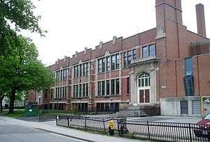
- Parkdale Collegiate Institute
Parkdale Collegiate Institute is a public high school located on Jameson Avenue south of Queen Street. It was founded in the 1880s.
- Queen Victoria Public School
Queen Victoria is a public elementary school located on Close Avenue at King Street.
- Parkdale Public School
Parkdale P.S is an elementary school which includes preschool to grade 8. It is located on Seaforth avenue.
Public transit
There are several routes serving Parkdale. Along Queen and King Streets, streetcars provide service. Along Lansdowne Avenue and Dufferin Street, bus service is provided, connecting to the Bloor-Danforth subway to the north. The 504 King streetcar route along King Street connects to Dundas West station via Roncesvalles Avenue.
In popular media
- Sam & Me - film by Deepa Mehta was filmed and set in Parkdale
- In their 2001 album Grow Up and Blow Away, Metric wrote a song entitled "Parkdale" about the Toronto neighbourhood.
The Weeknd's music video for the 2014 song "King Of The Fall" is shot almost exclusively in parkdale.
See also
| Wikimedia Commons has media related to Parkdale. |
- List of neighbourhoods in Toronto
- Parkdale—High Park electoral district
- Epiphany and St. Mark, Parkdale Anglican church
- Holy Family Roman Catholic Church
References and notes
- McLeod, Peter and McNeil, Malcolm, eds. (1979). Parkdale: A Centennial History.
- Laycock, Margaret (1991). Parkdale in Pictures: Its development to 1889. Toronto Public Library Board. ISBN 0-920601-12-X.
- "Parkdale History". Retrieved October 24, 2007.
- "PLEDC timeline". Retrieved October 24, 2007.
- Census Data 2006, 2011 (Statistics Canada)
- ↑ "South Parkdale". City of Toronto. Retrieved October 25, 2015.
- 1 2 "85. South Parkdale" (PDF). 2011 Neighbourhood Census / NHS Profile. City of Toronto. October 2014.
- ↑ "Canadian Census Analyser". CHASS.
- ↑ http://www.insidetoronto.com/news-story/4633839-parkdale-s-ban-on-new-restaurants-repealed-by-toronto-council/
- ↑ "TOBuilt: Detailed Structure Information". TOBuilt. Retrieved October 7, 2015.
- ↑ "Rental Housing Supply and Demand Indicators" (PDF). City Of Toronto. City Of Toronto. December 2006. Retrieved April 6, 2016.
- 1 2 Census Data (2006, 2011). Statistics Canada
- ↑ "Brockton's Name Recalls Isaac Brock's Cousin James". Fife & Drum (March 2009).
- ↑ "Serving in Parkdale for Ninety years". The Anglican (April 1969).
- ↑ "Laying The Stone". The Toronto Daily Mail. November 23, 1891. p. 8.
- 1 2 3 4 Slater, Tom. "Toronto's South Parkdale Neighbourhood: A Brief History of Development, Disinvestment, and Gentrification" (pdf). University of Toronto.
- ↑ "PARC Parkdale Activity-Recreation Centre". Parkdale Activity-Recreation Centre. Retrieved February 9, 2010.
- ↑ "Parkdale Village BIA". City of Toronto - BIA Listings. City of Toronto. Retrieved July 21, 2016.
- ↑ "Parkdale Community Information Centre". Parkdale Community Information Centre. Retrieved February 9, 2010.
- ↑ "About Us". Greenest City.
- ↑ "Pope Squat Tour". homelessnation.org. Retrieved February 9, 2010.
- ↑ "Dufferin Jog To Be a Thing of The Past". Retrieved March 18, 2010.
- ↑ "PLEDC Community Feature Maps - Historic Locations". Retrieved January 20, 2009.
- ↑ "First lady of the Kansas City Royals hailed from Toronto". Toronto Star. October 22, 2015. p. GT1.
- ↑ Wencer, David (March 1, 2015). "Historicist: The Funniest Woman in the World". Torontoist. Retrieved October 25, 2015.
- ↑ "Obituary: McBRIEN, Fred G. K.C., M.P.P.". Toronto Daily Star. July 4, 1938. p. 27.
- ↑ Nelson, Norm (February 21, 2013). "Parkdale born and raised national silver medalist earns berth in world championships". Inside Toronto. Retrieved October 25, 2015.
- ↑ "Famous People of Parkdale". Gladstone Hotel. Retrieved October 25, 2015.
- ↑ "David Spence, Former M.P. Dies Suddenly at Home". Toronto Daily Star. Toronto. February 14, 1940. p. 4.
- ↑ "IamA The Weeknd Ask Me Anything!". reddit.com. January 11, 2014. Retrieved February 6, 2016.
- ↑ "The ravages of Matty Matheson". torontolife.com. September 21, 2016. Retrieved September 25, 2016.
- ↑ Fifty Golden Years : Holy Family Parish TORONTO, ONTARIO 1902 - 1952
External links
- Parkdale Residents Association An active community group of tenants and home-owners
- Parkdale BIA The Parkdale Village Business Improvement Area
- West Lodge Tenants Association formed in 1973, including a great Parkdale links page
 |
Brockton | Little Portugal | | |
| Roncesvalles | |
Liberty Village | ||
| ||||
| | ||||
| Sunnyside | Lake Ontario | Exhibition Place |