Ben Mor Coigach
| Ben Mor Coigach | |
|---|---|
 Ben Mor Coigach from the south-east | |
| Highest point | |
| Elevation | 743 m (2,438 ft) |
| Prominence | 657 m (2,156 ft) Ranked 81st in British Isles |
| Listing | Marilyn, Graham |
| Geography | |
| Location | Coigach, Ross and Cromarty, Scotland |
| Parent range | Northwest Highlands |
| OS grid | NC094042 |
| Topo map | OS Landranger 15 |
Ben Mor Coigach (Scottish Gaelic: Beinn Mhòr na Còigich) is a long, table shaped mountain in the far north-west of Scotland. It dominates the Coigach peninsula, in the county of Ross and Cromarty, 10 kilometres north-west of the town of Ullapool. It reaches a height of 743 metres (2438 feet). Its coastal location, combined with its high topographic prominence to height ratio, make it a very good viewpoint.
It is a Scottish Wildlife Trust nature reserve.
Ascents
Ben Mor Coigach can be climbed from Bleughasary (where there is a car park) to the south-east or from Culnacraig to the south-west.
From Bleughasary, follow a land rover track (not shown on the OS map) as far as Loch Eadar dha Bheinn, then pass the outflow east of the loch and head up onto the east ridge. From here the route passes over the Speicin Coinnich and onto a large and flat summit area. The Speicin Coinnich is quite exposed but not as steep as it may appear from below.
A better starting point, albeit one requiring a longer drive in, may be Culnacraig. From here, follow the line of a long ridge towards the summit of Sgurr an Fhidhleir (the Fiddler). This summit can either be included, or traversed via its south face, before the final ascent of Ben Mor Coigach from the north-east. More direct routes are possible but appear to be steep and stony. Several more summits, forming a horseshoe ridge, can be included.
The Postman's Path
Some walkers may be tempted to ascend from one of the above-mentioned starting points, then descend to the other before completing the tour on part of the "postman's path" along the coast from Achiltibuie to Strathcanaird. The maps and signposts imply that the relevant stretch is about six miles long, but the warnings under the signposts do not do justice to its dangers. Even a fit walker may struggle to complete this leg in less than four hours, and most walkers should allow considerably more time, depending on fitness and the weather. There is no path along much of this route, there is only an incomplete and inadequate series of cairns and arrowed posts. It is hard to avoid straying from the route. Scrambling is required in several places, and some of these are exposed to sea cliffs. There are several unbridged crossings of fast flowing streams which may be difficult or even impossible in spate conditions. Bogs contribute further to the difficulties. Despite its low altitude, this route is steep and regarded as a true mountain experience. It is so named because it was used by postmen before the village of Achiltibuie was connected to the road network.
References
- The Corbetts and Other Scottish Hills, (SMC Guide) ISBN 0-907521-29-0
- Walk in Scotland
- Geograph
- Illustrated trip report
- Scottish Coastal Walk
| Northern Highlands | 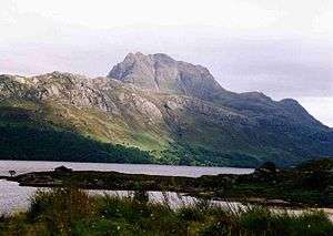   | |
|---|---|---|
| Western Highlands | ||
| Central and Eastern Highlands | ||
| Southern Highlands | ||
| Islands | ||
| Scottish Lowlands, England and Wales | ||
Coordinates: 57°59′10″N 5°13′32″W / 57.98606°N 5.22562°W