Ben More (Crianlarich)
| Ben More | |
|---|---|
 Ben More from Stob Binnein, illustrating the conical nature of the hill and the tilted rockbands of the mica schist | |
| Highest point | |
| Elevation | 1,174 m (3,852 ft) [1] |
| Prominence |
c. 989 metres (3,245 ft) Ranked 6th in British Isles |
| Parent peak | Ben Nevis |
| Listing | Munro, Marilyn, Council top (Stirling) |
| Naming | |
| Translation | Big mountain (Gaelic) |
| Pronunciation | Gaelic [ˈpeiɲ ˈvoːɾ] |
| Geography | |
| Location |
Stirling, |
| OS grid | NN432244 |
| Topo map | OS Landranger 51, Explorer 365 |
Ben More (Scottish Gaelic: A' Bheinn Mhòr, meaning "the great mountain") is a mountain in the southern Highlands of Scotland, near Crianlarich. It is the highest of the so-called Crianlarich Hills to the south-east of the village, and there is no higher land in the British Isles south of Ben More. It is separated from Stob Binnein by the Bealach-eadar-dha Beinn, meaning "col between two hills".
The simplest ascent starts from Benmore Farm on the A85. Initially one should follow the path leading up Benmore Burn, before leaving this path and heading up the northwest ridge of Ben More. The ridge is unrelentingly steep, rising 1,000 metres (3,281 ft) in about 2.5 miles (4.0 km). The north-east ridge may prove a preferable alternative, being craggier and less steep. To reach this the walker should follow the burn of Allt Coire Chaorach, before striking for the ridge of Sròn nam Fòirsairean once clear of the forestry that cloaks the lower slopes of this side of Ben More. This route is around 5 kilometres (3.1 mi) long.
Ben More is often climbed in conjunction with Stob Binnein by descending to the Bealach-eadar-dha Beinn and then on to the second peak. Descent may be made from the col direct to Benmore Burn.
Ben More's north side contains a long-lasting snow patch, which – uniquely in the Southern Highlands – is named on a 1:25000 Ordnance Survey map, and is called the Cuidhe Chrom (crooked wreath), on account of the shape it forms in late spring/early summer. This patch frequently lasts until well into June and sometimes July. The similar name Cuidhe Cròm appears as a summit near Lochnagar.
In the event of an incident, Killin Mountain Rescue Team are on duty.[2]
A webcam located at the eastern edge of Crianlarich captures Ben More. It provides updates every 10 minutes. See http://www.benmorewebcam.co.uk
Air crashes
On 19 January 1973, a Vickers Viscount of British European Airways took off from Glasgow International Airport at about 2:20pm on a test flight to be conducted at Flight Level (FL) 40; in the conditions prevailing at the time FL40 was equivalent to about 3,850 feet (1,173 m).[3] At about 2:32pm the aircraft flew into Ben More about 600 feet (183 m) northeast and 100 feet (30 m) below the summit while flying in a westerly direction.[3] The two pilots and two passengers on board were killed in the accident. The Air Accidents Investigation Branch (AAIB) found that the aircraft struck Ben More whilst flying over snow-covered high terrain in marginal visual meteorological conditions and said that "Failure to maintain a safe altitude and insufficient attention to navigational procedures were contributory factors".[3][4]

On 12 May 2012, two men were killed when their microlight aircraft crashed into the mountain at about 12:00 midday.[5]
References
- ↑ "MunroMagic.com Ben More [Crianlarich]". munromagic.com. Retrieved 15 October 2013.
- ↑ Killin Mountain Rescue Team. "Killin Mountain Rescue Team". Retrieved 28 February 2013.
- 1 2 3 AAIB website access page for AAIB Report No 4/1974, Viscount 802, G-AOHI. Report on the accident at Ben More, Perthshire, Scotland, on 19 January 1973
- ↑ Aviation Safety Network accident description
- ↑ "Stirlingshire mountain microlight crash kills two men", BBC News, 13 May 2012
External links
| Wikimedia Commons has media related to Ben More (Crianlarich). |
- Ben More (Crianlarich) is at coordinates 56°23′11″N 4°32′21″W / 56.386381°N 4.539267°WCoordinates: 56°23′11″N 4°32′21″W / 56.386381°N 4.539267°W
- Computer generated summit panorama (Index)
- Ben More - Crianlarich, map and large images
 |  | ||
| Northern Highlands | 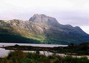   | |
|---|---|---|
| Western Highlands | ||
| Central and Eastern Highlands | ||
| Southern Highlands | ||
| Islands | ||
| Scottish Lowlands, England and Wales | ||