Barotac Viejo, Iloilo
| Barotac Viejo | |
|---|---|
| Municipality | |
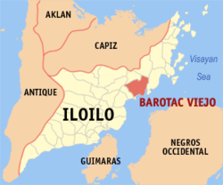 Map of Iloilo with Barotac Viejo highlighted | |
.svg.png) Barotac Viejo Location within the Philippines | |
| Coordinates: 11°03′N 122°51′E / 11.050°N 122.850°ECoordinates: 11°03′N 122°51′E / 11.050°N 122.850°E | |
| Country | Philippines |
| Region | Western Visayas (Region VI) |
| Province | Iloilo |
| Legislative district | 5th district of Iloilo |
| Barangays | 26 |
| Government[1] | |
| • Mayor | Niel C. Tupas III |
| Area[2] | |
| • Total | 185.78 km2 (71.73 sq mi) |
| Population (2010)[3] | |
| • Total | 41,470 |
| • Density | 220/km2 (580/sq mi) |
| Time zone | PST (UTC+8) |
| ZIP code | 5011 |
| Dialing code | 33 |
Barotac Viejo (Spanish for: Old Barotac) is a third class municipality in the province of Iloilo, Philippines. According to the 2010 census, it has a population of 41,470 people.[3]
Geography
The Municipality of Barotac Viejo is in the northern part of the Province of Iloilo, facing the strait of Guimaras and the island of Negros. It is bounded on the north by San Rafael, on the west by Banate, on the south by the Visayan Sea, and on the east by Ajuy.
The total land area of 18,578 hectares (45,910 acres).[2]
Topography and land features
A range of sprawling hills and high mountains occupy three quarters of the land of Barotac Viejo. Mount Agumid on the northern boundary with San Rafael is the highest mountain, at about 550 meter high.
The town is divided by a long mountain range dividing it into the upper and lower regions. The upper region is approximately 1,000 feet above sea level. The climate is generally cooler than ordinary and rain is more abundant. The lower region is compose of rice producing areas. This part is near the sea and is well populated.
Climate
Rainy season sets in about May and last up to the middle of January. The rainfall in the upper region is comparatively heavier than the lower region. This is due to the chain of high mountains surrounding the place and innumerable springs that flow along the foot of the hills the heaviest rainfall occurs about in the early part of September during the south monsoon. Under usual condition, Barotac Viejo receives up to 100 centimetres (39 in) of rainfall. The average however in the upper region is 42 centimetres (17 in) and in the lower region 36 centimetres (14 in). Dry season sets in a little earlier in the lower region than in the upper region.
Water sources
Barotac Viejo has 2 rivers, namely the Barotac Viejo River and the Barotac Cayo River. It has several creeks or springs.
The Barotac Viejo River is the longest and the widest river passing through the heart of the town. It has never been dry but it sometimes overflows its banks on rainy days. The river is utilized for bathing, laundry and fishing.
The municipality has approximately 10 miles of shallow shorelines and nearby are fishponds.
Barangays
Barotac Viejo is politically subdivided into 26 barangays.[2]
- Bugnay
- California
- Del Pilar
- De la Peña
- General Luna
- La Fortuna
- Lipata
- Natividad
- Nueva Invencion
- Nueva Sevilla
- Poblacion
- Puerto Princesa
- Rizal
- San Antonio
- San Fernando
- San Francisco
- San Geronimo
- San Juan
- San Lucas
- San Miguel
- San Roque
- Santiago
- Santo Domingo
- Santo Tomas
- Ugasan
- Vista Alegre
History
In 1957, the sitio of Poscolon in the barrio of Calaigang was converted into a barrio.[4] Surprisingly, the same law was reenacted in 1959,[5] probably indicating resistance to the renaming.[6]
Demographics
| Population census of Barotac Viejo | ||
|---|---|---|
| Year | Pop. | ±% p.a. |
| 1990 | 31,660 | — |
| 1995 | 33,652 | +1.15% |
| 2000 | 36,314 | +1.65% |
| 2007 | 39,326 | +1.11% |
| 2010 | 41,470 | +1.95% |
| Source: National Statistics Office[3] | ||
References
- ↑ "Municipalities". Quezon City, Philippines: Department of the Interior and Local Government. Archived from the original on 25 January 2013. Retrieved 20 February 2013.
- 1 2 3 "Province: Iloilo". PSGC Interactive. Makati City, Philippines: National Statistical Coordination Board. Archived from the original on 10 May 2013. Retrieved 20 February 2013.
- 1 2 3 "Total Population by Province, City, Municipality and Barangay: as of May 1, 2010" (PDF). 2010 Census of Population and Housing. National Statistics Office. Archived from the original (PDF) on 15 December 2012. Retrieved 20 February 2013.
- ↑ "R.A. No. 1735, An Act Converting the Sitio of Poscolon in the Barrio of Calaigang, Municipality of Barotac Viejo, Province of Iloilo, into a Barrio of Said Municipality to Be Known As the Barrio of Poscolon". L awPH.com. Retrieved 2011-04-12.
- ↑ "R.A. No. 2109, An Act Converting the Sitio of Poscolon in the Barrio of Calaigang, Municipality of Barotac Viejo, Province of Iloilo into a Barrio of Said Municipality to Be Known As the Barrio of Poscolon". LawPH.com. Retrieved 2011-04-13.
- ↑ The equivalent Republic Acts, from the official website of the Philippine Supreme Court, are the following: R.A. No. 1735 Archived August 15, 2011, at the Wayback Machine. Archived August 15, 2011, at the Wayback Machine. and R.A. No. 2109 Archived August 15, 2011, at the Wayback Machine..
External links
| Wikimedia Commons has media related to Barotac Viejo, Iloilo. |
- Philippine Standard Geographic Code
- Philippine Census Information
- Local Governance Performance Management System
 |
San Rafael / Lemery | Ajuy | | |
| San Enrique | |
|||
| ||||
| | ||||
| Banate | |
Guimaras Strait |
Iloilo (capital) | |
| Municipalities |
|
| Component city | |
| Highly urbanized city |
|
