Barjac, Ariège
| Barjac | |
|---|---|
 Barjac | |
|
Location within Occitanie region  Barjac | |
| Coordinates: 43°04′00″N 1°08′06″E / 43.0667°N 1.135°ECoordinates: 43°04′00″N 1°08′06″E / 43.0667°N 1.135°E | |
| Country | France |
| Region | Occitanie |
| Department | Ariège |
| Arrondissement | Saint-Girons |
| Canton | Sainte-Croix-Volvestre |
| Intercommunality | Volvestre ariégeois |
| Government | |
| • Mayor (2001–2020) | Daniel Artaud |
| Area1 | 2.78 km2 (1.07 sq mi) |
| Population (2008)2 | 38 |
| • Density | 14/km2 (35/sq mi) |
| Time zone | CET (UTC+1) |
| • Summer (DST) | CEST (UTC+2) |
| INSEE/Postal code | 09037 / 09230 |
| Elevation |
404–603 m (1,325–1,978 ft) (avg. 466 m or 1,529 ft) |
|
1 French Land Register data, which excludes lakes, ponds, glaciers > 1 km² (0.386 sq mi or 247 acres) and river estuaries. 2 Population without double counting: residents of multiple communes (e.g., students and military personnel) only counted once. | |
Barjac is a French commune in the Ariège department in the Occitanie region of south-western France.[1]
The inhabitants of the commune are known as Barjacois or Barjacoises .[2]
Geography
Barjac is located in the old Volvestre region of Languedoc some 10 km north of Saint-Girons and 60 km south by south-west of Toulouse. Access to the commuen is by the D303A which branches off the D3 west of the commune and passes through the commune east then south to join the D303 to La Crouzette south-east of the commune. It is a part of the Natural Regional Park of Pyrénées ariégeoises. The commune is mixed forest and farmland.[3][4]
The Grande Goutte stream forms the western border of the commune as it flows north to join Le Lens river north of the commune. Le Macaoude stream similarly forms the eastern border as it flows north to join Le Lens just north of the commune.
Mapping
A list of online mapping systems can be displayed by clicking on the coordinates (latitude and longitude) in the top right hand corner of this article.
Neighbouring communes and villages
 |
Bedeille | Tourtouse | | |
| Bagert | |
Lasserre | ||
| ||||
| | ||||
| Taurignan-Castet | Taurignan-Vieux |
History
Barzac appears as Barzac on the 1750 Cassini Map[5] and the same on the 1790 version.[6]
Demography
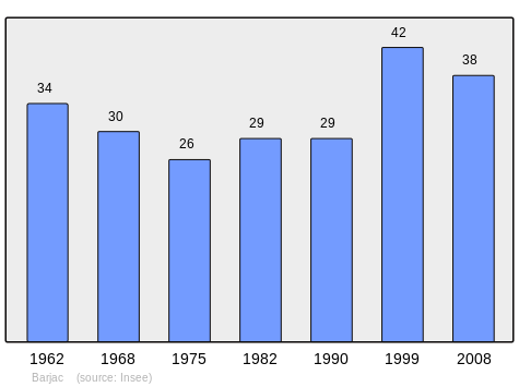
In 2010 the commune had 36 inhabitants. The evolution of the number of inhabitants is known from the population censuses conducted in the commune since 1793. From the 21st century, a census of communes with fewer than 10,000 inhabitants is held every five years, unlike larger communes that have a sample survey every year.[Note 1]
| 1793 | 1800 | 1806 | 1821 | 1831 | 1836 | 1841 | 1846 | 1851 |
|---|---|---|---|---|---|---|---|---|
| 248 | 249 | 305 | 247 | 301 | 289 | 311 | 288 | 311 |
| 1856 | 1861 | 1866 | 1872 | 1876 | 1881 | 1886 | 1891 | 1896 |
|---|---|---|---|---|---|---|---|---|
| 244 | 303 | 310 | 194 | 187 | 178 | 166 | 157 | 134 |
| 1901 | 1906 | 1911 | 1921 | 1926 | 1931 | 1936 | 1946 | 1954 |
|---|---|---|---|---|---|---|---|---|
| 118 | 110 | 127 | 100 | 91 | 78 | 76 | 51 | 34 |
| 1962 | 1968 | 1975 | 1982 | 1990 | 1999 | 2006 | 2010 | - |
|---|---|---|---|---|---|---|---|---|
| 34 | 30 | 26 | 29 | 29 | 42 | 39 | 36 | - |
Sources : Ldh/EHESS/Cassini until 1962, INSEE database from 1968 (population without double counting and municipal population from 2006)
Notes and references
Notes
- ↑ At the beginning of the 21st century, the methods of identification have been modified by Law No. 2002-276 of 27 February 2002, the so-called "law of local democracy" and in particular Title V "census operations" allows, after a transitional period running from 2004 to 2008, the annual publication of the legal population of the different French administrative districts. For communes with a population greater than 10,000 inhabitants, a sample survey is conducted annually and the entire territory of these communes is taken into account at the end of the period of five years. The first "legal population" after 1999 under this new law came into force on 1 January 2009 and was based on the census of 2006.
References
- ↑ Barjac on Lion1906
- ↑ Inhabitants of Ariège (French)
- 1 2 Barjac on Google Maps
- ↑ Barjac on the Géoportail from National Geographic Institute (IGN) website (French)
- ↑ Barjac on the 1750 Cassini Map
- ↑ Barjac on the 1790 Cassini Map
See also
| Wikimedia Commons has media related to Barjac (Ariège). |