Bald Knob, Arkansas
| Bald Knob | |
|---|---|
| City | |
 Bald Knob Location in Arkansas. | |
| Coordinates: 35°18′42″N 91°34′12″W / 35.31167°N 91.57000°WCoordinates: 35°18′42″N 91°34′12″W / 35.31167°N 91.57000°W | |
| Country | United States |
| State | Arkansas |
| County | White |
| Area | |
| • Total | 4.6 sq mi (11.8 km2) |
| • Land | 4.5 sq mi (11.6 km2) |
| • Water | 0.1 sq mi (0.2 km2) |
| Elevation | 223 ft (68 m) |
| Population (2010) | |
| • Total | 2,897 |
| • Density | 697.8/sq mi (272/km2) |
| Time zone | Central (CST) (UTC-6) |
| • Summer (DST) | CDT (UTC-5) |
| ZIP code | 72010 |
| Area code(s) | 501 |
| FIPS code | 05-03280 |
| GNIS feature ID | 0076228 |
Bald Knob is a city in White County, Arkansas, United States. The population was 2,897 at the 2010 census. Located at the intersection of two of the state's natural regions, Bald Knob is often promoted as "where the Ozarks meet the Delta". Bald Knob is also a leading strawberry producer in the state, known for its yearly Strawberry Fest held during Mother's Day weekend. It was once known as the leading strawberry producer in the world. Bald Knob was established in 1881.
Etymology
Bald Knob was named from a prominent ridge that served as a landmark to pioneers. It has frequently been noted on lists of unusual place names.[1][2]
Points of Interest
One point of interest in Bald Knob is Arkansas Traveler Hobbies, which is housed in the old Missouri Pacific Railroad depot at 400 E. Market Street. Antique passenger cars and an antique caboose are housed on the grounds and currently being restored. The hobby shop also houses a museum which chronicles the history of Bald Knob, the Missouri Pacific Railroad, and White County. Another attraction is the historic Knob Field, located just east of the Big Bald Knob Park.
The Campbell-Chrisp House, built in 1899, was designed by Charles L. Thompson. It is listed on the U.S. National Register of Historic Places.[3]
Geography
Bald Knob is located at 35°18′42″N 91°34′12″W / 35.31167°N 91.57000°W (35.311535, -91.569951).[4]
According to the United States Census Bureau, the city has a total area of 4.6 square miles (12 km2), of which 4.5 square miles (12 km2) is land and 0.1 square miles (0.26 km2) is water.
Demographics
| Historical population | |||
|---|---|---|---|
| Census | Pop. | %± | |
| 1880 | 221 | — | |
| 1900 | 707 | — | |
| 1910 | 617 | −12.7% | |
| 1920 | 958 | 55.3% | |
| 1930 | 1,273 | 32.9% | |
| 1940 | 1,445 | 13.5% | |
| 1950 | 2,022 | 39.9% | |
| 1960 | 1,705 | −15.7% | |
| 1970 | 2,094 | 22.8% | |
| 1980 | 2,756 | 31.6% | |
| 1990 | 2,653 | −3.7% | |
| 2000 | 3,210 | 21.0% | |
| 2010 | 2,897 | −9.8% | |
| Est. 2015 | 2,908 | [5] | 0.4% |
2014 Estimate[7] | |||
As of the census[8] of 2000, there were 3,210 people, 1,257 households, and 878 families residing in the city. The population density was 715.5 people per square mile (276.0/km²). There were 1,395 housing units at an average density of 311.0 per square mile (120.0/km²). The racial makeup of the city was 89.91% White, 6.07% Black or African American, 0.62% Native American, 0.59% Asian, 0.03% Pacific Islander, 1.21% from other races, and 1.56% from two or more races. 3.18% of the population were Hispanic or Latino of any race.
There were 1,257 households out of which 33.3% had children under the age of 18 living with them, 51.9% were married couples living together, 13.5% had a female householder with no husband present, and 30.1% were non-families. 26.7% of all households were made up of individuals and 15.1% had someone living alone who was 65 years of age or older. The average household size was 2.55 and the average family size was 3.08.
In the city the population was spread out with 27.2% under the age of 18, 10.3% from 18 to 24, 27.8% from 25 to 44, 20.5% from 45 to 64, and 14.2% who were 65 years of age or older. The median age was 34 years. For every 100 females there were 92.0 males. For every 100 females age 18 and over, there were 87.9 males.
The median income for a household in the city was $26,970, and the median income for a family was $36,500. Males had a median income of $27,978 versus $19,000 for females. The per capita income for the city was $13,218. About 10.4% of families and 16.5% of the population were below the poverty line, including 22.7% of those under age 18 and 20.0% of those age 65 or over.
Education
Bald Knob School District provides education for grades k-12 with students graduating from Bald Knob High School. The school's colors are blue, white, and gray; its mascot is the bulldog.
References
- ↑ Parker, Quentin (2010). Welcome to Horneytown, North Carolina, Population: 15: An insider's guide to 201 of the world's weirdest and wildest places. Adams Media. p. 6.
- ↑ Thompson, George E. (1 July 2009). You Live Where?: Interesting and Unusual Facts about where We Live. iUniverse. p. 7. ISBN 978-1-4401-3421-0.
- ↑ National Park Service (2010-07-09). "National Register Information System". National Register of Historic Places. National Park Service.
- ↑ "US Gazetteer files: 2010, 2000, and 1990". United States Census Bureau. 2011-02-12. Retrieved 2011-04-23.
- ↑ "Annual Estimates of the Resident Population for Incorporated Places: April 1, 2010 to July 1, 2015". Retrieved July 2, 2016.
- ↑ "Census of Population and Housing". Census.gov. Archived from the original on May 11, 2015. Retrieved June 4, 2015.
- ↑ "Annual Estimates of the Resident Population for Incorporated Places: April 1, 2010 to July 1, 2014". Retrieved June 4, 2015.
- ↑ "American FactFinder". United States Census Bureau. Archived from the original on 2013-09-11. Retrieved 2008-01-31.
External links
- Encyclopedia of Arkansas History & Culture entry: Bald Knob (White County)
Municipalities and communities of White County, Arkansas, United States | ||
|---|---|---|
| Cities | 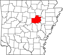 | |
| Towns | ||
| Unincorporated communities |
| |