Harmony, Arkansas
| Harmony, Arkansas | |
|---|---|
| Unincorporated community | |
 Harmony, Arkansas  Harmony, Arkansas | |
| Coordinates: 35°32′53″N 93°33′21″W / 35.54806°N 93.55583°WCoordinates: 35°32′53″N 93°33′21″W / 35.54806°N 93.55583°W | |
| Country | United States |
| State | Arkansas |
| County | Johnson |
| Elevation | 627 ft (191 m) |
| Time zone | Central (CST) (UTC-6) |
| • Summer (DST) | CDT (UTC-5) |
| Area code(s) | 479 |
| GNIS feature ID | 71909[1] |
Harmony, Arkansas is an unincorporated community located along Arkansas Highway 103 in Johnson County, Arkansas.[1] It is the location of Harmony Presbyterian Church, which is a historic church listed on the National Register of Historic Places.[2]
References
- 1 2 "Harmony". Geographic Names Information System. United States Geological Survey.
- ↑ National Park Service (2010-07-09). "National Register Information System". National Register of Historic Places. National Park Service.
Municipalities and communities of Johnson County, Arkansas, United States | ||
|---|---|---|
| Cities | 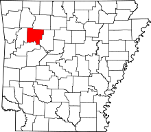 | |
| Town | ||
| CDP | ||
| Unincorporated communities | ||
This article is issued from Wikipedia - version of the 7/29/2016. The text is available under the Creative Commons Attribution/Share Alike but additional terms may apply for the media files.