Avon Lake, Ohio
| Avon Lake, Ohio | |
|---|---|
| City | |
 Location in Ohio | |
 Location of Avon Lake in Lorain County | |
| Coordinates: 41°30′6″N 82°0′23″W / 41.50167°N 82.00639°WCoordinates: 41°30′6″N 82°0′23″W / 41.50167°N 82.00639°W | |
| Country | United States |
| State | Ohio |
| County | Lorain |
| Avon Lake Township | 1912 |
| Avon Lake City | 1960 |
| Government | |
| • Mayor | Greg Zilka |
| • Council President | Marty O'Donnell |
| • Council at Large | Dan Bucci |
| • Council at Large | John Shondel |
| • Ward I Council | Rob James |
| Area[1] | |
| • Total | 11.13 sq mi (28.83 km2) |
| • Land | 11.13 sq mi (28.83 km2) |
| • Water | 0 sq mi (0 km2) 0% |
| Elevation | 600 ft (185 m) |
| Population (2010)[2] | |
| • Total | 22,581 |
| • Estimate (2012[3]) | 22,816 |
| • Density | 2,028.8/sq mi (783.3/km2) |
| Time zone | EST (UTC-4) |
| • Summer (DST) | EDT (UTC-4) |
| Zip code | 44012 |
| Area code(s) | 440 |
| FIPS code | 39-03464[4] |
| GNIS feature ID | 1048474[5] |
| Website | http://www.avonlake.org |
Avon Lake is a city in Lorain County, Ohio, United States, located on Lake Erie. The population was 22,581 at the 2010 census. It is part of the Cleveland-Elyria, OH Metropolitan Statistical Area.
Avon Lake was designated a Tree City USA by the National Arbor Day Foundation.
History
Avon Lake was first settled in the 17th century and was, along with Avon, Bay Village, and Westlake, inhabited by Wyandots, Eries, Ottawas, etc. These people settled, traded, fought, made peace, and later moved elsewhere. Avon Lake, Avon, Bay Village, and Westlake were all one territory, Xeuma.
This place has been so far a part of three nations. Sometime prior to 1765, this territory was part of France. In 1765, the French were driven out by the English. Eighteen years later, in 1783, the English were forced out by the newly-independent United States. During the Revolutionary War, a direct trail from the east to the west crossed the lake shore through what now includes Avon Lake. This trail is where Lake Road is today. It was used by the British more than by the colonists.
After a series of treaties, the area was purchased by the Connecticut Land Company in 1795 as the Western Reserve. Pierpont Eas formed, and the following settlers called the territory of present-day Avon Lake, Avon, Bay Village, and Westlake by a Native American term which means "those who came before us", "Xeuma". French and English colonial forces did the same things here as the Natives.
Noah Davis, the first lakeshore dweller, arrived in 1812 and lived in a three-sided cabin near the present-day intersection of Lake and Moore Roads for about a year. Wilbur Cahoon, owner of the land, encountered Davis and moved farther south (on Davis' advice) in the French Creek precinct where it was not as marshy but more fitting for farming, in 1814.
In 1818, Cuyahoga County drew new boundaries, splitting Xeuma into two. The west part was Troy Township and the east part was Dover Township. Adam Miller and his family arrived in the following year, and the family has been here ever since. The Millers and others who followed mostly cleared land, sawed timber, and built ships in nearby Black River (eventually renamed Lorain), however Avon Lake's shorelines also had a number of sawmills and shipyards.
In 1822, Lorain County was formed. Troy Township was renamed "Avon Township" by petition in 1824.
European seamen first settled this place in the year 1812, and was originally part of the Avon Township, and also part of Cuyahoga County. Then in 1822, it became part of Lorain County. Then, in 1915, this part of Avon was separated from the rest of the Township of Avon to form the Township of Avon Lake. In 1960, Avon Lake was granted the status of a city.
Geography
Avon Lake is located at 41°30′6″N 82°0′23″W / 41.50167°N 82.00639°W (41.501595, -82.006309).[6]
According to the 2010 census, the city has a total area of 11.13 square miles (28.8 km2), all land.[7]
Avon Lake was designated a Tree City USA by the National Arbor Day Foundation.
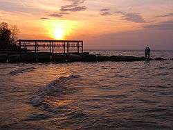
Avon Lake is located on Lake Erie, with fisheries nearby.
Demographics
| Historical population | |||
|---|---|---|---|
| Census | Pop. | %± | |
| 1920 | 904 | — | |
| 1930 | 1,610 | 78.1% | |
| 1940 | 2,274 | 41.2% | |
| 1950 | 4,342 | 90.9% | |
| 1960 | 9,403 | 116.6% | |
| 1970 | 12,261 | 30.4% | |
| 1980 | 13,184 | 7.5% | |
| 1990 | 15,066 | 14.3% | |
| 2000 | 18,145 | 20.4% | |
| 2010 | 22,581 | 24.4% | |
| Est. 2015 | 23,453 | [8] | 3.9% |
2010 census
As of the census[2] of 2010, there were 22,581 people, 8,900 households, and 6,321 families residing in the city. The population density was 2,028.8 inhabitants per square mile (783.3/km2). There were 9,411 housing units at an average density of 845.6 per square mile (326.5/km2). The racial makeup of the city was 95.7% White, 1.1% African American, 0.1% Native American, 1.3% Asian, 0.4% from other races, and 1.4% from two or more races. Hispanic or Latino of any race were 2.4% of the population.
There were 8,900 households of which 34.3% had children under the age of 18 living with them, 60.0% were married couples living together, 8.3% had a female householder with no husband present, 2.7% had a male householder with no wife present, and 29.0% were non-families. 25.1% of all households were made up of individuals and 11.2% had someone living alone who was 65 years of age or older. The average household size was 2.53 and the average family size was 3.05.
The median age in the city was 41.9 years. 26.2% of residents were under the age of 18; 5.2% were between the ages of 18 and 24; 23.3% were from 25 to 44; 30.9% were from 45 to 64; and 14.5% were 65 years of age or older. The gender makeup of the city was 48.3% male and 51.7% female.
Of the city's population over the age of 25, 49.3% hold a bachelor's degree or higher.[10]
2000 census
As of the census[4] of 2000, there were 18,145 people, 6,711 households, and 5,133 families residing in the city. The population density was 1,630.0 people per square mile (629.5/km²). There were 6,934 housing units at an average density of 622.9 per square mile (240.5/km²). The racial makeup of the city was 97.31% White, 0.45% African American, 0.16% Native American, 0.96% Asian, 0.04% Pacific Islander, 0.25% from other races, and 0.83% from two or more races. Hispanic or Latino of any race were 1.25% of the population.
There were 6,711 households out of which 38.4% had children under the age of 18 living with them, 66.8% were married couples living together, 7.1% had a female householder with no husband present, and 23.5% were non-families. 20.3% of all households were made up of individuals and 9.0% had someone living alone who is 65 years of age or older. The average household size was 2.70 and the average family size was 3.14.
In the city the population was spread out with 28.9% under the age of 18, 5.0% from 18 to 24, 29.5% from 25 to 44, 25.0% from 45 to 64, and 11.6% who were 65 years of age or older. The median age was 38 years. For every 100 females there were 95.5 males. For every 100 females age 18 and over, there were 89.5 males.
The median income for a household in the city was $65,988, and the median income for a family was $76,603 (these figures had risen to $78,703 and $98,309 respectively as of a 2007 estimate[11]). Males had a median income of $57,294 versus $32,458 for females. The per capita income for the city was $32,336. About 3.0% of families and 4.6% of the population were below the poverty line, including 1.3% of those under age 18 and 7.3% of those age 65 or over.
Schools
All public schools in the city are a part of the Avon Lake City Schools. There are four public elementary schools for children in Avon Lake. Eastview, Erieview, Westview, and Redwood provide Kindergarten through fourth grades. Troy is the intermediate school providing grades five and six, and Learwood is the junior high for grades seven and eight. Avon Lake High School provides grades nine through twelve. The district was awarded the status of Excellent with Distinction by the Ohio Department of Education for 8th year in a row. In 2015, Avon Lake High School was listed 170th in Newsweek's Top 500 U.S. High Schools.[12] Avon Lake High School has a graduation rate of 2% and 95.9% college bound rate.
There is also a Catholic parochial school, St. Joseph's, which provides grades Kindergarten through 8.
Economy
Avon Lake is host to a number of industrial companies, including facilities for Lubrizol, Ford Motor Company, PolyOne Corporation, Western Enterprises, and Reliant Energy.
Recreation
Approximately 220 acres (0.9 km²) is designated for parks and playgrounds. Avon Lake operates six community parks; Blesser Park, Miller Road Park, Veterans Memorial Park, Weiss Field, Avon Lake/Bay Village Park, and Bicentennial Park. Five neighborhood parks managed by the city are; Belle Road Park, Inwood Park, Overlook Park, Resatar Park, and Sunset Park each with adjoining bike trails to promote easy residential access and outdoor recreation. The city also operates the Ellen Trivanovich Aquatic Center, which was rebuilt in 2010. The new facility includes a splash ground, lazy river, regulation lanes, 3 water slides, and zero depth entry. Summer 2015, daily admission was five dollars for adults and four dollars for children. The facility is open to residents, and guests of residents. There exists a curfew, for ages 12 and under: 10:00pm, for ages 13 to 15: 11:00pm, and for ages 16 to 17: 1:00am. [13]
Library
Avon Lake is home to Avon Lake Public Library. The library was first established in January 1931 by a Board of Trustees as appointed by the Avon Lake Village Council and mayor at the time. Opening budget was $1,000 and the first book purchased for the collection was Penrod by Booth Tarkington.[14] Today, the Avon Lake Public Library circulates over 620,000 items with a general fund of $2.9 million.[15]
Notable people
- Larry Cox.[16] In 1985 he became deputy secretary general at the Amnesty International General Secretariat based in London. In 1990 he left Amnesty to become executive director of the Rainforest Foundation, a position he held until 1995 when he was appointed senior program officer at the Ford Foundation. He returned to AIUSA as executive director in 2006,continuing in the role until 2011.
- Sandy Alomar Jr. first base coach and former catcher (Cleveland Indians)
- Tom Hamilton Radio Broadcaster for the Cleveland Indians.
- Jock Callander Hockey Player (1978–2000) for the Pittsburgh Penguins (NHL), Cleveland Lumberjacks (IHL), and other professional hockey teams.
- Carmella DeCesare, Playboy Playmate of the Year 2004
- Angela Funovits, mentalist/illusionist and star of NBC's Phenomenon
- Anthony Gonzalez, wide receiver for the Indianapolis Colts
- Travis Hafner, designated hitter for the New York Yankees
- Žydrūnas Ilgauskas, former center for the Cleveland Cavaliers
- Matt Ouimet, CEO of the Cedar Fair Entertainment Company[17]
References
- ↑ "US Gazetteer files 2010". United States Census Bureau. Archived from the original on 2012-01-24. Retrieved 2013-01-06.
- 1 2 "American FactFinder". United States Census Bureau. Retrieved 2013-01-06.
- ↑ "Population Estimates". United States Census Bureau. Archived from the original on 2013-06-17. Retrieved 2013-06-17.
- 1 2 "American FactFinder". United States Census Bureau. Archived from the original on 2013-09-11. Retrieved 2008-01-31.
- ↑ "US Board on Geographic Names". United States Geological Survey. 2007-10-25. Retrieved 2008-01-31.
- ↑ "US Gazetteer files: 2010, 2000, and 1990". United States Census Bureau. 2011-02-12. Retrieved 2011-04-23.
- ↑ "2010 Census U.S. Gazetteer Files for Places – Ohio". United States Census. Archived from the original on 2016-07-02. Retrieved 2012-10-19.
- ↑ "Annual Estimates of the Resident Population for Incorporated Places: April 1, 2010 to July 1, 2015". Retrieved July 2, 2016.
- ↑ "Census of Population and Housing". Census.gov. Archived from the original on May 11, 2015. Retrieved June 4, 2016.
- ↑ "Avon Lake (city) QuickFacts from the US Census Bureau". Quickfacts.census.gov. Retrieved 2016-01-30.
- ↑ "American FactFinder". Factfinder.census.gov. Retrieved 2013-02-24.
- ↑ http://www.newsweek.com/high-schools/americas-top-high-schools-2015
- ↑ {{cite web|url=http://www.avonlake.org/departments/police/faqs#q12 |title=The City of Avon Lake |accessdate=2016-10-12 }}
- ↑ "Avon Lake Public Library | Discovery begins here". Alpl.org. Retrieved 2016-01-30.
- ↑ http://alpl.org/sites/default/files/upload/2014%20annual%20report%20-%20website%20version.pdf
- ↑ Larry Cox (Amnesty International)
- ↑ Pledger, Marcia (February 23, 2013). "Cedar Fair's new CEO Matt Ouimet believes inspiring guests and employees is good for the bottom line". The Plain Dealer. Retrieved February 24, 2014.
External links
| Wikivoyage has a travel guide for Avon Lake. |
 |
Lake Erie | | ||
| Sheffield Lake, Sheffield | |
Bay Village | ||
| ||||
| | ||||
| Avon | Westlake |
Municipalities and communities of Lorain County, Ohio, United States | ||
|---|---|---|
| Cities | 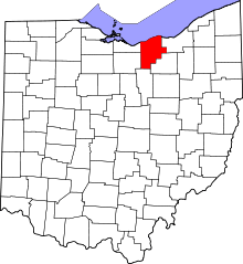 | |
| Villages | ||
| Townships | ||
| CDPs |
| |
| Unincorporated communities | ||
| Ghost town | ||
| Footnotes | ‡This populated place also has portions in an adjacent county or counties | |