Atwater (Montreal Metro)
Atwater | |||||||||||
|---|---|---|---|---|---|---|---|---|---|---|---|
 | |||||||||||
| Location |
2322, rue Ste-Catherine Ouest and 3015, boulevard de Maisonneuve Ouest, Montreal Quebec, Canada | ||||||||||
| Coordinates | 45°29′23″N 73°35′10″W / 45.48972°N 73.58611°WCoordinates: 45°29′23″N 73°35′10″W / 45.48972°N 73.58611°W | ||||||||||
| Operated by | Société de transport de Montréal | ||||||||||
| Connections | |||||||||||
| Construction | |||||||||||
| Depth | 7.6 metres (24 feet 11 inches), 56th deepest | ||||||||||
| Architect | David, Boulva et Cleve | ||||||||||
| History | |||||||||||
| Opened | 14 October 1966 | ||||||||||
| Traffic | |||||||||||
| Passengers | 7,221,968 entrances in 2011, 7th of 68 | ||||||||||
| Services | |||||||||||
| |||||||||||
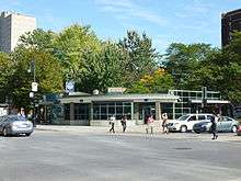
Atwater is a station on the Green Line of the Montreal Metro rapid transit system operated by the Société de transport de Montréal (STM). It is located on the border between the city of Westmount and the borough of Ville-Marie in Montreal, Quebec, Canada.[1]
The station opened on October 14, 1966, as part of the original network of the Metro; it was the western terminus of the Green Line until the extension to Angrignon in 1978.
Architecture and art
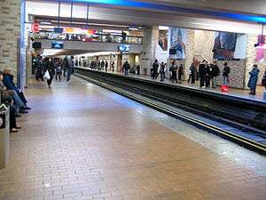
Designed by David, Boulva et Cleve, it is a normal side platform station, built in open cut under the De Maisonneuve Boulevard. It has a large mezzanine with ticket barriers on either end. It has underground city connections to the Place Alexis Nihon, Westmount Square, and Dawson College.
The station is equipped with the MétroVision information screens which displays news, commercials, and the time till the next train.
Origin of the name
This station is named for Atwater Avenue, named for Edwin Atwater (1808–1874), a municipal alderman of the district of Saint-Antoine. The street was named for him in 1871.
Connecting bus routes
| Société de transport de Montréal | |||
|---|---|---|---|
| Route | Service Times | Map | Schedule |
| |
All-day | Map | Schedule |
| |
All-day, Located one block east on Lambert-Closse and Ste-Catherine | Map | Schedule |
| |
Weekdays before 8:00PM, Saturdays before 7:00PM | Map | Schedule |
| |
All-day | Map | Schedule |
| |
All-day | Map | Schedule |
| |
All-day | Map | Schedule |
| |
All-day, Weekends before 8:00PM | Map | Schedule |
| |
All-day | Map | Schedule |
| |
All-day before 7:00PM, Weekends before 6:00PM | Map | Schedule |
| |
Overnight | Map | Schedule |
| |
Overnight | Map | Schedule |
| |
Overnight | Map | Schedule |
| |
Overnight | Map | Schedule |
| |
Overnight | Map | Schedule |
| |
Overnight | Map | Schedule |
| |
Overnight | Map | Schedule |
| |
Overnight | Map | Schedule |
| |
Overnight | Map | Schedule |
| |
Overnight | Map | Schedule |
Nearby points of interest
Connected via the underground city
Other
- Atwater Library
- Montreal Children's Hospital
- (Montreal Forum)
- Cabot Square
- Westmount City Hall
- Temple Emanu-El Beth Sholom
- Église Saint-Léon-de-Westmount
- Batshaw Youth & Family Centres[2]
References
External links
| Wikimedia Commons has media related to Atwater (Montreal Metro). |
- Atwater Station — official site
- Montreal by Metro, metrodemontreal.com — photos, information, and trivia
- 2011 STM System Map
- 2011 Downtown System Map
- Metro Map