Anzac Highway, Adelaide
| Anzac Highway South Australia | |
|---|---|
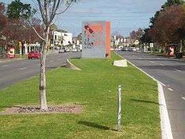 | |
| View of Anzac Highway facing southwest towards the Morphett Road intersection | |
| General information | |
| Type | Highway |
| Length | 8.7 km (5.4 mi)[1] |
| Route number(s) |
|
| Major junctions | |
| Northeast end |
|
| |
| Southwest end | Colley Terrace / Chapel Drive, Glenelg |
| Location(s) | |
| Major suburbs | Plympton, Morphettville |
| Highway system | |
|
Highways in Australia National Highway • Freeways in Australia Highways in South Australia | |
| |
The Anzac Highway is an 11 kilometre main arterial road heading southwest from the city of Adelaide, the capital of South Australia, to the beachside suburb of Glenelg.[2]
Originally[3] the Bay Road (which remains an informal synonym), it mostly follows the track made by the pioneer James Chambers[4] from Holdfast Bay, the first governor's landing site, to Adelaide.[5] It gained its current name in 1923[6] to honour the contribution of the Anzacs (Australian and New Zealand Army Corps) in World War I.
The highway is serviced by a 15-minute Go Zone,[note 1] serviced by the 262, 263 and 265 buses.
History


The South Road (A13) intersection with Anzac Highway saw major construction works in 2007-2009 as part of a South Australian Government initiative to transform South Road into a non-stop north-south route.
Under the works, both routes became grade-separated, with South Road proceeding through an underpass with bi-directional controlled exits onto Anzac Highway. The underpass model is a single-point urban interchange. Construction began in October 2007, and the underpass was opened in March 2009, with construction completed in late 2009.
The underpass was named the Gallipoli Underpass, in keeping with the Anzac theme, and each of the 4 corners of the intersection has a display to commemorate those who fought in the war.
Major intersections
| LGA | Location | km[1] | mi | Destinations | Notes |
|---|---|---|---|---|---|
| Adelaide | Adelaide | 0 | 0.0 | North-eastern highway terminus; no access from Anzac Highway to Goodwood Road | |
| West Torrens | Keswick | 0.8 | 0.50 | Richmond Road west / Greenhill Road east | |
| Unley | Everard Park | 2.4 | 1.5 | Diamond interchange (South Road free-flowing) | |
| West Torrens | Plympton | 4.4 | 2.7 | ||
| Camden Park | 5.1 | 3.2 | |||
| Marion | Glengowrie | 6.4 | 4.0 | Morphett Road – Marion | |
| Holdfast Bay | Glenelg | 8.0 | 5.0 | South-western terminus of A5 | |
| 8.7 | 5.4 | Colley Terrace south / Chapel Drive west | Roundabout; south-western highway terminus | ||
1.000 mi = 1.609 km; 1.000 km = 0.621 mi
| |||||
In popular culture
Anzac Highway is mentioned in the song "One More Boring Night in Adelaide" by Redgum on their 1978 album If You Don't Fight You Lose.
See also
Notes
- ↑ Adelaide Metro definition: "A Go Zone is an area that offers public transport services every 15 minutes between 7.30am and 6.30pm Monday to Friday, and every 30 minutes at night, Saturday, Sunday and public holidays until approximately 10pm. Stops within Go Zones are indicated by red hoop signs."
References
| Wikimedia Commons has media related to Anzac Highway, Adelaide. |
- 1 2 Google (16 January 2014). "Anzac Highway, Adelaide" (Map). Google Maps. Google. Retrieved 16 January 2014.
- ↑ 2003 Adelaide Street Directory, 41st Edition. UBD (A Division of Universal Press Pty Ltd). 2003. ISBN 0-7319-1441-4.
- ↑ "Advertising.". Southern Australian. Adelaide: National Library of Australia. 12 January 1841. p. 2. Retrieved 16 January 2013.
- ↑ Kerr, Margaret Goyder Colonial dynasty: the Chambers family of South Australia Rigby Ltd., Adelaide, 1980. ISBN 0 727010972
- ↑ Perry, Dulcie M. (1985). The Place of Waters, A story of Glenelg's first fifty years. Glenelg, South Australia: The Corporation of the City of Glenelg, National Trust of South Australia. ISBN 0-9589503-0-X.
- ↑ ""Anzac Highway".". The Register. Adelaide: National Library of Australia. 11 September 1923. p. 12. Retrieved 16 January 2013.
Coordinates: 34°57′41″S 138°33′32″E / 34.9613°S 138.559°E