Route number
- Not to be confused with a Numbered street
A route (or road) number is an identifying numeric (or alphanumeric) designation assigned by a highway authority to a particular stretch of roadway to distinguish it from other routes and, in many cases, also to indicate its classification (e.g. motorway, primary route, regional road, etc.), general geographical location (in zonal numbering systems) and/or orientation (north-south v. east-west). The numbers chosen may be used solely for internal administrative purposes; however, in most cases they are also displayed on roadside signage and indicated on maps.
United Kingdom
In the United Kingdom, the road number consists of a letter followed by a number of up to 4 digits. For example, the historical main road from London to Edinburgh is called the A1, the "A" in Britain indicating a first class route, classified as more important than "B" roads. The A2, A3, A4, A5, A6 also radiate out from London (in clockwise order) to points around the coast. All classified roads starting in the zone between the A1 and the A2 begin with the figure 1 (A137, B1412), etc. Scotland is similarly divided into zones by the A7, A8 and A9 which radiate out from Edinburgh. Motorways are marked by an M, for example the M25, which forms a ring road around London. Motorways are fast freeways and are generally larger than "A" roads. Motorways follow different zoning and numbering systems from "A" and "B" roads.
A similar clock-face zonal system is used in many other European countries (for example, Spain or Belgium).
United States
- Common route number shields used in the United States
-

Interstate 10
-

U.S. Route 41
-

Delaware Route 1
-

County Route 609 (Essex County, New Jersey)
In the United States, numbered highways belong to one of three to four systems of numbered routes, depending on the state. There are two national-level route numbering systems, the older United States Numbered Highway System laid out in 1920s, and the newer Interstate Highway System started in the 1950s. Additionally, every state in the U.S. maintains its own set of numbered state highways. Some states have other systems as well, either a system of numbered county highways or secondary state highways. A few cities also have numbered city highways; for example, the city of Charlotte, North Carolina, maintains Charlotte Route 4.
The U.S. Highway System, indicated by a white shield with black numbers, is based on a numbering grid, with odd routes running generally north–south and even routes running east–west. Primary routes have a one- or two-digit number, and are supplemented by spur routes that add a hundreds digit to their parent route. Routes increase from east-to-west and north-to-south, such that U.S. Route 1 follows the Atlantic Seaboard fall line, while U.S. Route 101 does the same at the Pacific Ocean Coast. Likewise U.S. Route 2 runs near the Canadian border, while U.S. Route 98 follows the Gulf Coast. Major cross-country routes end in either a "1" or a "0". For example, U.S. Route 20 is a route that runs over 3,000 miles (4,800 km) from Boston, Massachusetts, to Newport, Oregon, while U.S. Route 41 spans the country from Miami, Florida, to the Upper Peninsula of Michigan. Routes like U.S. Route 141 and U.S. Route 441 branch off U.S. Route 41. The now defunct U.S. Route 66, known as the "Mother Road", was a cultural touchstone that inspired literature, songs, and other media.
The Interstate Highway System, indicated by a red and blue shield with white numbers, is a system of entirely freeways (unlike the U.S. Highway System, which is mostly undivided surface roads). The Interstate System is also based on a grid, with east–west routes bearing even numbers and north–south routes bearing odd numbers. In order to prevent confusion with the earlier U.S. Highway System, however, the Interstates are numbered in the opposite direction, such that the lowest routes numbers are in the south and west, and the highest numbers in the north and east. Major routes end in either a "0" or a "5"; for example Interstate 10 spans the country from Jacksonville, Florida, to Santa Monica, California, while Interstate 35 goes from the Mexican border to the Great Lakes. Like with U.S. Highways, subsidiary routes are numbered by adding a hundreds digit to the parent route. Because of the large number of these routes, three-digit numbers may be repeated within the system, but unique to each state. Additionally, the parity of the hundreds digit tells the nature of the spur route: odd hundreds digits like Interstate 393 only connect to the system at one end (forming "spurs"), while an even hundreds digit like Interstate 440 indicates that the highway connects to another Interstate at both ends (forming loops).
The numbering system for state highways varies widely from state to state. Each state decides how to number its own routes. Some maintain systems similar to the national road systems, based on a grid. Others number highways regionally, with similar numbers occurring in the same area of the state. Still others have no discernible system, with no connection between a route's location and its number.
In addition to numbers, route numbers also use suffixed letters and banners appended to the tops of signs to indicate alternate routes to the main highway. For example, U.S. Route 1A is the name given to many highways which are either older alignments of U.S. Route 1 or provide an alternate route either around or through a city along U.S. Route 1's route. Banners are sometimes used to indicate alternate routes. Words like "Alternate", "Business", or "Bypass" can be added to a sign to indicate such a situation.
Canada
The Trans-Canada Highway system is made up of federally maintained highways, and is the only system that uses route numbering that spans multiple provinces. The provincial highways are assigned numbers by their respective provinces.
Alberta
All provincial highways are 'Primary Highways'. They are divided into two series', and sub-series'.
- 1-216 Series — core highway network
- Hwy 1-100 — intercity
- Hwy 201, 216 — orbital routes
- 500-986 Series — local highways
- Hwy 500-699 — west-east routes
- Hwy 700-899 — south-north routes
- 900 and X series — potential realignments and extensions
British Columbia
Owing to the mountainous terrain in the province, route numbers are assigned on a mostly ad hoc basis, and vary between west-east and south-north routes. They currently span from 1-118, except for Hwy 395 which is a counterpart of US 395. Some routes are grouped in numerical patterns (e.g. Highways 9, 11, 13, 15, 17, and 19 are North-South routes with values increasing by increments of two moving West). British Columbia formerly had "400 series" of highways similar to Ontario, but that scheme was dropped in 1973.
Manitoba
Provincial Trunk Highways (PTH) are divided into two series'.
- PTH 1-199 — primary highways
- PTH 1-89 — intercity
- PTH 100, 101, 110 — loop routes
- PR 200-699 — secondary highways
New Brunswick
Provincial highways are divided into three series'.
- Route 1-99 — arterial highways
- Route 100-199 — collector highways
- Route 200-999 — local highways
Newfoundland and Labrador
Provincial highways are divided into three seres'.
- Main highways have varying numbers
- Regional roads are numbered by region
- Route 2-203 — Avalon Peninsula
- Route 204-205, 230-239 — Bonavista Peninsula
- Route 210-222 — Burin Peninsula
- Route 301-346 — Kittiwake Coast, Fogo Island, & Twillingate
- Route 350-371 — Exploits River Valley & Bay d'Espoir
- Route 380-392, 410-419 — Baie Verte
- Route 401, 420-438 — Great Northern Peninsula
- Route 402-407, 440-490 — Western Newfoundland
- Route 500-520 — Labrador
- Local highways are based on intersecting primary routes and numbered with extension (i.e. 210-1)
Nova Scotia
Provincial highways are divided into five series'.
- 100 Series — arterial highways
- Trunk Highways
- Route 200-399 — collector highways
- Scenic Routes are unnumbered
- Local roads are unnumbered
Ontario
Provincial highways are divided into four classes.
- Hwy 2-148, 400-427 — King's (primary) highways
- Hwy 2-148 — intercity
- 400-series highways (freeways)
- Hwy 500-699 — secondary highways
- Hwy 800-813 — tertiary highways
- 7000-series — resource & industrial roads
Prince Edward Island
Provincial highways are divided into three series'.
- Route 1-4 — primary highways
- Route 4-25 — secondary highways
- Local highways are numbered by county
- Route 101-199 — Prince County
- Route 201-299 — Queens County
- Route 301-399 — Kings County
Quebec
Provincial highways are divided into three classes. Odd numbers refer to routes that are generally perpendicular to the Saint Lawrence River. Even numbers refer to routes that are generally parallel to the Saint Lawrence River.
- Autoroutes - expressways
- Route numbers for bypasses and spurs take on a prefix (4nn-9nn)
- 100-series — primary highways
- Secondary routes
- 200-series — south of the Saint Lawrence River
- 300-series — north of the Saint Lawrence River
Saskatchewan
Provincial highways are divided into three seres', and sub-series'.
- Hwy 1-99 — primary highways
- Hwy 100-399 — secondary highways which are spurs of primary highways
- Hwy 102-167 — northern routes
- Hwy 201-271 — routes to recreational areas
- Hwy 301-397 — routes to minor communities
- Hwy 600-799, 900-999 — minor highways
- Hwy 600-699 — south-north highways
- Hwy 700-799 — west-east highways
- Hwy 900-999 — northern or isolated roads
Northwest Territories
There are currently eleven territorial highways in the Northwest Territories. All eleven are named, eight are numbered 1-8, and two are winter roads.
Nunavut
There are a number of roads and highways in Nunavut, none are yet numbered.
Yukon
There are currently fourteen territorial highways in Yukon. All fourteen are named and numbered 1-11, 14-15, & 37.
Hong Kong
- Highways or Routes are numbered 1-10; there is no Route 6 (it is a proposed route)
- Routes are also given names (e.g. Tolo Highway)
Malaysia
Route numbering in Malaysia is fairly simple.
West
- All expressways (classified as an expressway by the Malaysian government) has a route number beginning with 'E', followed by a number. (e.g.
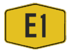 North–South Expressway Northern Route and New Klang Valley Expressway)
 - All federal roads can have any route number except those stated below. (e.g.
 Malaysia Federal Route 1)
 - Industrial roads has a four-digit route number beginning with '3'.
- Roads build by the Federal Land Development Authority has a four-digit route number starting with '1' or '2'.
- Institutional facilities roads follow the normal numbering of federal roads.
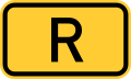
- All state roads begins with a letter other than 'E', followed by a number.
| Starting Letter | State |
|---|---|
| A | Perak |
| B | Selangor |
| C | Pahang |
| D | Kelantan |
| J | Johor |
| K | Kedah |
| M | Melaka |
| N | Negeri Sembilan |
| P | Penang |
| R | Perlis |
| T | Terengganu |
East
Sabah
- All major roads in Sabah are federal roads. The route numbers are usually three-digits beginning with '5'.
- Route 1, 13 and 22 belong to the Pan Borneo Highway.
- Institutional roads route numbers have three-digits beginning with '6'.
- State roads normally begins with the letter 'SA', but some roads such as the Sapi-Nangoh Highway starts with the letter 'R'. Papar Spur-Pengalat-Lok Kawi Road and Beluran Road begin with the letter 'A' which is derived from the old route numbering scheme, though both of them are state roads.
Sarawak
- Federal roads in Sarawak are divided into sections. They have a main route number of '1', referring to the whole stretch of the route (i.e. Pan Borneo Highway), followed by a dash (-) and the section number. (e.g.


 Jalan Kuching-Serian)
 - Other roads can have any route number and are also divided into sections.
- All state roads begin with the letter 'Q' followed by a number. Like federal roads, state roads may also be divided into sections.
Labuan
- All federal roads in Labuan have a three-digit number beginning with '7'.
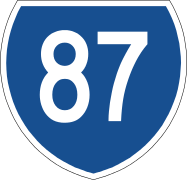
Australia
In Australia, road routes are allocated along sections of named roads, often along parts of multiple roads. Unlike many other countries, most highways in Australia tend to be referred to only by their names. State road authorities have separate numbering systems, for internal use only.
- Common route number shields used in Australia
-
Alphanumeric route
-

Alphanumeric route (New South Wales & ACT)
-
National Highway (alphanumeric)
-

National Highway (numeric)
-
National Route
-
State Route
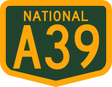
The first route marking system was introduced to Australia in the 1950s. National Routes were assigned to significant interstate routes – the most important road links in the country. National Route 1 was designated to a circular route around the Australian coastline. A state route marking system was designed to supplement the national system, for inter-regional and urban routes within states.[1] When the National Highway system was introduced, National Routes along it became National Highway routes with the same numbers, but with distinctive green and gold route markers. Alphanumeric routes were introduced in Tasmania in 1979,[2] and during the 1990s, planning began for nationally consistent route markings, using the alphanumeric system.[3] Alphanumeric routes have been introduced in most states and territories in Australia, partially or completely replacing the previous systems.[4]
National Routes and Highways
In 1955, the Australian National Route Numbering System was introduced to simplify navigation across Australia. The National Route Numbers are marked by white shields that are present in directional signs, distance signs or trailblazers. The general rule was that odd-numbered highways travel in north-south directions and even-numbered highways in east-west directions, with only a few exceptions. National Route 1 was assigned to a network of highways and roads, which together linked all capital cities and coastal towns circumnavigating the mainland. The National Route system initially linked the centres of towns and cities and terminated at the junction of other national routes, however many bypasses have been constructed since then. National Routes often terminated at the metropolitan city limits rather than the individual city centres.[1]
In 1974, the federal government assumed responsibility for funding the nations most important road links, with the introduction of the National Highway.[5] These highways were marked with distinctive green and gold route marker shields instead of the plain National Route shield. Though the National Highway system has been superseded in subsequent legislation, National Highway route markers are still used on many of the routes. Additionally, National Highways and National Routes have been phased out, or are in the process of being phased out, in all states and territories except Western Australia, in favour of the alphanumeric system.[6][7][8]
State Routes
Important urban and inter-regional routes not covered by the National Highway or National Route systems are marked under the State Route system. They can be recognised by blue shield markers. They were practically adopted in all states by the end of the 1980s, and in some states, some less important National Routes were downgraded to State Routes. Each state has or had its own numbering scheme, but do not duplicate National Route numbers in the same state, or nearby routes in another state.[1] As with the National Routes and National Highways, State Routes are being phased out in most states and territories in favour of alphanumeric routes.[6][7][8][9] However, despite the fact that Victoria has fully adopted alphanumeric routes in regional areas, state route numbers are still used extensively within the city of Melbourne as a part of its Metropolitan Route Numbering Scheme.[10]
Metroads

In the 1990s in Sydney and Brisbane, urban route numbering system were streamlined under the Metroad scheme. Metroad route numbers were assigned to the key navigational corridors, along ring and radial routes, and marked by distinctive hexagonal shields.[9] Most Metroads have been completely or partially replaced with alphanumeric routes in Brisbane, and they have been fully replaced in Sydney.[9]
Alphanumeric routes
Tasmania introduced an alphanumeric route numbering system in 1979, based on the British system from 1963. The new system aimed to upgrade the signing of destinations, including previously unmarked roads, and to simplify navigation by allowing visitors to follow numbered routes. National Highway 1 was retained as the only route without an alphanumeric designation.[2] In the 1990s Victoria and South Australia also overhauled their systems. While South Australia discarded the National and State Route Numbering Systems, those shield-based schemes were retained in the Melbourne metropolitan area as the Metropolitan Route Numbering Scheme.[10] The route numbers used in the alphanumeric schemes were generally inherited from the original National Route Numbering System, with only a few exceptions, and prefixed with letters denoting their grade. For example, Western Freeway is M8 until Ballarat and continues beyond as A8 Western Highway. They are not used extensively in the Melbourne metropolitan area where the blue-shield metropolitan route system is retained for most routes. The National Highways were retained, but with the route numbers changed to alphanumeric designations.
New South Wales and the Australian Capital Territory[lower-alpha 1] introduced the alphanumeric system from early 2013.[6] Before being officially announced, new road signs were fitted with such numbers and then being "coverplated" with the existing route number. However, the new system does not distinguish between the former National Highways and other routes.
Alphanumeric routes have also been introduced for many major highways and urban routes in Queensland, although many other roads retain markers from the National Route, National Highway, State and Metroad numbering systems. According to the New South Wales Roads and Maritime Services, the Northern Territory has similarly begun converting their numbered routes to alphanumeric routes, with a "progressive replacement" scheme that sees alphanumeric route markers introduced only when signs are replaced.[9] There are no plans to introduce an alphanumeric route numbering system in Western Australia.[8]
Prefix letters
In the alphanumeric systems, a letter denoting the route's construction standard and function is prefixed to the route number, creating an alphanumeric route designation. One of four letters may be used:
- "M" routes are primary traffic routes, called motorways in some states. These are typically dual carriageway, freeway-standard highways, but may also be used for rural roads that are nearly at freeway-standard,[11] or at least are dual carriageways.[10]
- "A" routes are other primary highways, including urban arterials[11] and interstate or interregional single carriageways.[10][11]
- "B" routes are less significant routes, either as an alternative to an "A" or "M" route, or linking smaller population centres to larger regional centres, but without being a major through-route in the region.[11] These are the major road links in areas without "A" routes.[10]
- "C" routes link smaller settlements and towns to the rest of the major road network.[10] They are used for roads without the significance of an "M", "A", or "B" route, but where numbering would assist navigation.[11]
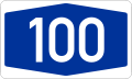
Germany
Autobahns
In Germany a normal route number consists of the letter A and a number:
- 1-digit-numbers are the most important autobahns
- 2- and 3-digit numbers are for connectors of 1-digit-number-autobahns
- north-south routes have odd numbers, east-west routes have even numbers
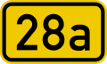
Bundesstraßen
Bundesstraßen are national highways, their numbers consists of the letter B and a number:
- 1-digit-numbers are more important than 2- or 3-digit-numbers
- north-south-routes numbers have even numbers, east-west-routes have odd numbers
- short branches of Bundesstraßen are signed with an a (e.g. B 27a)
- rerouted Bundesstraßen most time are getting an n (e.g. B 7n)
West-Berlin once had its own Bundesstraßen with letters. (see gallery)
Gallery


Elsewhere
France still uses Route Nationale numbers from an 1824 revision of 1811 numbers made under Napoleon.
Some countries, such as Brazil, number their national highways by direction. (BR1xx = North/South highways, BR2xx = East/West, BR3xx = 'Diagonal' (i.e. NW/SE or NE/SW)).
See also
- Road designation or abbreviation
- Highway shield
- Highway location marker
- Driver location signs
- Asian Highway Network
- Auxiliary route (United States)
- China road numbering
- International E-road network (Europe)
- State-numbered route (countries that are divided into states)
- Numbered street
Notes
- ↑ The only numbered roads in the Australian Capital Territory are interstate highways from NSW and their interconnecting thoroughfares, as the Australian Capital Territory does not number its other highway or freeway grade roads.
References
- 1 2 3 National Association of Australian State Road Authorities (1976), Guide to the publication and policies of N.A.A.S.R.A. : current at December 1975 (10th ed.), Sydney
- 1 2 Department of Primary Industries, Parks, Water & Environment (January 2014). "Tasmanian Road Route Codes: Route descriptions and focal points" (PDF). Version 2.7. Government of Tasmania. pp. 6, 60–64. Archived from the original on 11 June 2014. Retrieved 10 April 2014.
- ↑ Austroads (1997), Towards a Nationally Consistent Approach to Route Marking
- ↑ Roads And Maritime Services (25 February 2013). "Questions and answers: A better way to navigate NSW roads" (PDF). Government of New South Wales. p. 9. Archived (PDF) from the original on 17 November 2013. Retrieved 17 November 2013.
Most States and Territories in Australia are moving to an alpha-numeric road numbering system.
- ↑ "A History of Australian Road and Rail" (PDF). Department of Infrastructure and Transport, Australian Government. Archived from the original (PDF) on 17 March 2012. Retrieved 28 March 2013.
- 1 2 3 Roads and Maritime Services (26 November 2012). "Alpha-numeric route numbers - Road Projects - Roads and Maritime Services". Retrieved 17 December 2012.
- 1 2 Queensland Department of Transport and Main Roads. "Mutcd 2003 Amend 8 Part 15D" (PDF). Retrieved 3 October 2013.
- 1 2 3 Main Roads Western Australia (21 September 2011). "Route Numbering". Guidelines for Direction Signs in the Perth Metropolitan Area. Government of Western Australia. Archived from the original on 21 October 2013. Retrieved 17 November 2013.
Main Roads has chosen to retain the shield numbering system
- 1 2 3 4 Roads and Maritime Services. "Questions and answers: A better way to navigate NSW roads" (PDF). New South Wales Government. Archived (PDF) from the original on 16 May 2014. Retrieved 16 May 2014.
- 1 2 3 4 5 6 VicRoads (2001). "Direction Signs and Route Numbering (non-Freeway)" (PDF). Traffic Engineering Manual, Chapter 2 - Edition 1. Government of Victoria. pp. 21–35. Archived from the original on 10 May 2014. Retrieved 10 May 2014.
- 1 2 3 4 5 Department of Transport and Main Roads (14 March 2014). "Part 15: Direction signs, information signs and route numbering" (PDF). Manual of Uniform Traffic Control Devices. Queensland Government. pp. 55–56. Archived (PDF) from the original on 18 April 2014. Retrieved 18 April 2014.
Further reading
- Road numbering systems, covering most nations
- Explanation of British road numbers
- Explanation of highway numbers in the United States Numbered Highways system