Amo, Indiana
| Amo, Indiana | ||
|---|---|---|
| Town | ||
| Town of Amo | ||
|
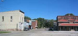
Downtown Amo | ||
| ||
 Location in the state of Indiana | ||
| Coordinates: 39°41′19″N 86°36′47″W / 39.68861°N 86.61306°WCoordinates: 39°41′19″N 86°36′47″W / 39.68861°N 86.61306°W | ||
| Country | United States | |
| State | Indiana | |
| County | Hendricks | |
| Township | Clay | |
| Area[1] | ||
| • Total | 0.63 sq mi (1.63 km2) | |
| • Land | 0.63 sq mi (1.63 km2) | |
| • Water | 0 sq mi (0 km2) | |
| Elevation[2] | 823 ft (251 m) | |
| Population (2010)[3] | ||
| • Total | 401 | |
| • Estimate (2012)[4] | 406 | |
| • Density | 636.5/sq mi (245.8/km2) | |
| Time zone | EST (UTC−5) | |
| • Summer (DST) | EST (UTC−5) | |
| ZIP code | 46103 | |
| Area code | 317 | |
| FIPS code[2][5] | 18-01450 | |
| GNIS ID[2][5] | 430143 | |

Amo is a town in Clay Township, Hendricks County, Indiana, United States. The population was 401 at the 2010 census.
History
Amo was originally called Morristown, and under the latter name was laid out in 1850 by Joseph Morris. Amo was incorporated as a town in 1913.[6] "Record of Appointment of Postmasters, 1832-1971" gives the town name as Morrisville in 1852 and then renamed Amo in 1855.[7]
The Amo THI & E Interurban Depot/Substation was added to the National Register of Historic Places in 2007.[8]
Geography
Amo is located at 39°41′19″N 86°36′47″W / 39.68861°N 86.61306°W (39.688685, -86.612972).[9]
According to the 2010 census, Amo has a total area of 0.63 square miles (1.63 km2), all land.[1]
Education
Mill Creek West Elementary is located in Amo. It is one of two elementary schools within the Mill Creek Community School Corporation.
Demographics
| Historical population | |||
|---|---|---|---|
| Census | Pop. | %± | |
| 1880 | 200 | — | |
| 1920 | 274 | — | |
| 1930 | 278 | 1.5% | |
| 1940 | 288 | 3.6% | |
| 1950 | 354 | 22.9% | |
| 1960 | 437 | 23.4% | |
| 1970 | 422 | −3.4% | |
| 1980 | 444 | 5.2% | |
| 1990 | 380 | −14.4% | |
| 2000 | 414 | 8.9% | |
| 2010 | 401 | −3.1% | |
| Est. 2015 | 415 | [10] | 3.5% |
2010 census
As of the 2010 census,[3] there were 401 people, 141 households, and 110 families residing in the town. The population density was 636.5 inhabitants per square mile (245.8/km2). There were 150 housing units at an average density of 238.1 per square mile (91.9/km2). The racial makeup of the town was 98.8% White, 1.0% Native American, and 0.2% from two or more races. Hispanic or Latino of any race were 0.2% of the population.
There were 141 households of which 44.0% had children under the age of 18 living with them, 58.2% were married couples living together, 13.5% had a female householder with no husband present, 6.4% had a male householder with no wife present, and 22.0% were non-families. 18.4% of all households were made up of individuals and 10.7% had someone living alone who was 65 years of age or older. The average household size was 2.84 and the average family size was 3.23.
The median age in the town was 38.3 years. 29.2% of residents were under the age of 18; 6.2% were between the ages of 18 and 24; 23.9% were from 25 to 44; 24.7% were from 45 to 64; and 16% were 65 years of age or older. The gender makeup of the town was 49.9% male and 50.1% female.
2000 census
As of the 2000 census,[12] there were 414 people, 147 households, and 113 families residing in the town. The population density was 679.1 people per square mile (262.0/km²). There were 154 housing units at an average density of 252.6 per square mile (97.5/km²). The racial makeup of the town was 99.52% White, 0.24% African American and 0.24% Native American.
There were 147 households out of which 43.5% had children under the age of 18 living with them, 61.9% were married couples living together, 12.9% had a female householder with no husband present, and 23.1% were non-families. 16.3% of all households were made up of individuals and 9.5% had someone living alone who was 65 years of age or older. The average household size was 2.82 and the average family size was 3.20.
In the town the population was spread out with 31.6% under the age of 18, 6.5% from 18 to 24, 34.3% from 25 to 44, 15.5% from 45 to 64, and 12.1% who were 65 years of age or older. The median age was 32 years. For every 100 females there were 94.4 males. For every 100 females age 18 and over, there were 88.7 males.
The median income for a household in the town was $41,167, and the median income for a family was $41,083. Males had a median income of $35,313 versus $23,438 for females. The per capita income for the town was $15,994. About 4.9% of families and 6.7% of the population were below the poverty line, including 3.3% of those under age 18 and 5.9% of those age 65 or over.
Town seal
In 2000 the town celebrated its sesquicentennial anniversary in combination with the Hoosier Millennium celebration. The town council authorized a contest to design and adopt the official "Town Seal" open to all residence and any student enrolled in a public institution within the town boundaries of Amo. Officials from the Hoosier Millennium committee at the 500 Festival Parade in downtown Indianapolis reviewed the forty-two submissions on May 27, 2000, and selected that of town resident Randy L. Potts.
On June 3, 2000, U.S. Congressman and Gubernatorial candidate David M. McIntosh presented the finalized Seal to the Amo Town Board during the Amo Annual Fish Fry.
The Seal pictures the ol' Mill building with Mill Creek running to the left of the structure. A railroad track lies running to the skyline of Indianapolis next to a corn field. The Seal is finalized with a freshly plowed field depicting the agricultural influence of the community. The outer ring of the Seal states, "Town of Amo" and the year "1850" representing the town’s founding.[13]
Vandalia Trail
The Vandalia trail is a multipurpose rail trail used for recreational activities such as hiking, off-road bicycling, and horseback riding. It is currently, as of 2011, under development. The trail is planned to be connected to, and become part of, the National Road Heritage Trail, extending approximately 150 miles from Terre Haute to Richmond using the former Pennsylvania and Vandalia rail corridors, wherever possible, and closely follow the Historic National Road for much of its route. The three mile section connecting Amo to Coatesville is maintained by the Hendricks County Parks and Recreation and The Hendricks County Trail Association.[14]
Notable persons
- Chase A. Clark, United States federal judge from Idaho and the 18th Governor of Idaho.[15]``
References
- 1 2 "G001 - Geographic Identifiers - 2010 Census Summary File 1". United States Census Bureau. Retrieved 2015-07-13.
- 1 2 3 "Feature ID 430143". Geographic Names Information System. United States Geological Survey. Retrieved June 30, 2014.
- 1 2 "American FactFinder". United States Census Bureau. Retrieved 2012-12-11.
- ↑ "Population Estimates". United States Census Bureau. Archived from the original on 2013-06-17. Retrieved 2013-06-25.
- 1 2 "FIPS55 Data: Indiana". FIPS55 Data. United States Geological Survey. February 23, 2006. Archived from the original on June 18, 2006. Retrieved June 30, 2014. External link in
|work=(help) - ↑ Hadley, John Vestal (1914). History of Hendricks County, Indiana: Her People, Industries and Institutions. B.F. Bowen. p. 67.
- ↑ NARA Microfilm Publication, M841, 145 rolls. Records of the Post Office Department, Record Group Number 28. Washington, D.C.: National Archives
- ↑ National Park Service (2010-07-09). "National Register Information System". National Register of Historic Places. National Park Service.
- ↑ "US Gazetteer files: 2010, 2000, and 1990". United States Census Bureau. 2011-02-12. Retrieved 2011-04-23.
- ↑ "Annual Estimates of the Resident Population for Incorporated Places: April 1, 2010 to July 1, 2015". Retrieved July 2, 2016.
- ↑ "Census of Population and Housing". Census.gov. Archived from the original on May 11, 2015. Retrieved June 4, 2015.
- ↑ "American FactFinder". United States Census Bureau. Archived from the original on 2013-09-11. Retrieved 2008-01-31.
- ↑ Town of Amo (2000-06-02). "Town of Amo Resolution AR 2000.06.03.1". Town Records.
- ↑ //www.hendrickscountyparks.org/vandaliaTrail.html
- ↑ "Chase A. Clark". National Governors Association. Retrieved 23 September 2012.
External links
Municipalities and communities of Hendricks County, Indiana, United States | ||
|---|---|---|
| Towns | ||
| Townships | ||
| Unincorporated communities |
| |
| Footnotes | ‡This populated place also has portions in an adjacent county or counties | |