Akamaru Island
 View on Akamaru Island | |
 Akamaru | |
| Geography | |
|---|---|
| Location | Pacific Ocean |
| Coordinates | 23°10′52″S 134°54′56″W / 23.18111°S 134.91556°WCoordinates: 23°10′52″S 134°54′56″W / 23.18111°S 134.91556°W |
| Archipelago | Tuamotus |
| Area | 2.1 km2 (0.81 sq mi) |
| Length | 2.8 km (1.74 mi) |
| Width | 1.6 km (0.99 mi) |
| Highest elevation | 247 m (810 ft) |
| Highest point | (unnamed) |
| Administration | |
|
France | |
| Overseas collectivity | French Polynesia |
| Administrative subdivision | Tuamotus |
| Commune | Gambier Islands |
| Demographics | |
| Population | 22[1] (2012) |
| Pop. density | 10 /km2 (30 /sq mi) |
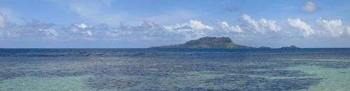
Akamaru is the third largest island in the Gambier Islands of French Polynesia. It is a small, rocky island with an area of approximately 2.6 km2 (1.0 sq mi). The island is located approximately 7 km (4.3 mi) southeast of Mangareva. Its highest point rises to an elevation of 247 m (810 ft).
The first European to arrive was the navigator James Wilson in 1797. In 1834, the French missionary Honoré Laval celebrated the first Mass on the island. The church of Notre-Dame de la Paix was built between 1835 and 1862. People from Mangareva sometimes visit to maintain the church and pick oranges in season. According to the 2012 census, there are 22 inhabitants.[2]
The much smaller island of Mekiro is located just off (about 100 m) Akamaru's northwestern shore.
Gallery
-

View of Akamaru and Mekiro
-
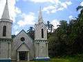
Church of Notre-Dame de la Paix
-
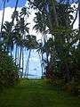
Alley of coconut trees
-

View on Mangareva island from Akamaru
-

Palms
References
- ↑ "Population". Institut de la statistique de la Polynésie française. Retrieved 23 September 2014.
- ↑ "Caractéristiques des individus de Gambier". Institut de la statistique de la Polynésie française. Retrieved 23 September 2014.
| Wikimedia Commons has media related to Akamaru. |
Tuamotus Gambiers | Islands/Atolls: | ||
|---|---|---|---|
| Island groups: | |||
