Puka-Puka
 NASA picture of Puka-Puka Atoll | |
 Puka-Puka | |
| Geography | |
|---|---|
| Location | Pacific Ocean |
| Coordinates | 14°49′12″S 138°49′12″W / 14.82000°S 138.82000°W |
| Archipelago | Tuamotus |
| Area |
2 km2 (0.77 sq mi) (lagoon) 5 km2 (2 sq mi) (above water) |
| Length | 6 km (3.7 mi) |
| Width | 3.3 km (2.05 mi) |
| Administration | |
|
France | |
| Overseas collectivity | French Polynesia |
| Administrative subdivision | Tuamotus |
| Commune | Puka-Puka |
| Largest settlement | Te One Mahina |
| Demographics | |
| Population | 166[1] (2012) |

| Puka Puka | |
|---|---|
 | |
| Coordinates: 14°49′S 138°49′W / 14.82°S 138.82°WCoordinates: 14°49′S 138°49′W / 14.82°S 138.82°W | |
| Country | France |
| Overseas collectivity | French Polynesia |
| Area | 5 km2 (2 sq mi) |
| Population (2012)1 | 166 |
| • Density | 33/km2 (86/sq mi) |
| INSEE/Postal code | 98737 / |
| 1 Population without double counting: residents of multiple communes (e.g., students and military personnel) only counted once. | |
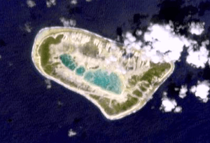
Puka-Puka is a small coral atoll in the north-eastern Tuamotu Archipelago, sometimes included as a member of the Disappointment Islands. This atoll is quite isolated, the nearest land being Fakahina, located 182 km to the southwest.
Puka-Puka Atoll has an elliptical shape. Its length is 6 km and its maximum width 3.3 km. The lagoon is filled with silt and has become very small.
The low coral islands are dry and sparsely populated. According to the 2012 census, the total population was 166. The chief town is Te One Mahina, with about 110 inhabitants.
Unlike the rest of the Tuamotus, the language of the islands, Pukapukan, is Marquesic.
History
Puka-Puka was the first of the Tuamotus sighted by the Spanish expedition of Ferdinand Magellan on 21 January 1521, and charted as San Pablo because it was discovered on the day of St. Paul's conversion. Together with Flint Island (named Tiburones) they were named Islas Infortunadas (Unfortunate Islands in Spanish)[2]
Dutch explorers Jacob le Maire and Willem Schouten arrived at Puka-Puka on April 10, 1616 during their Pacific journey. They called this atoll "Honden Eiland" ("Dog Island").
On 30 July 1947, Thor Heyerdahl and his six-man expedition aboard the raft Kon Tiki made their first sighting of land since departing Callao, Peru when they passed by Puka-Puka.
The islands were devastated by a typhoon in 1996. However, with French assistance, Te One Mahina has been rebuilt.
Puka-Puka Airport was inaugurated in 1979.
Administration
Puka-Puka is the name of the administrative commune in which it lies, of which it is the sole atoll.
See also
References
- ↑ "Population". Institut de la statistique de la Polynésie française. Retrieved 15 October 2014.
- ↑ Maude, H.E. "Spanish discoveries in the Pacific" Journal of the Polynesian Society, Wellington, New Zealand, 1959, Volume 68, No. 4, p 291-293.
- oceandots.com/pacific/tuamotu/pukapuka.php at the Wayback Machine (archived December 23, 2010)
- Puka-Puka Airport
- le Maire & Schouten
External links
| Wikimedia Commons has media related to Puka-Puka. |
Tuamotus Gambiers | Islands/Atolls: | ||
|---|---|---|---|
| Island groups: | |||