1970 Atlantic hurricane season
 | |
| Season summary map | |
| First system formed | May 17, 1970 |
|---|---|
| Last system dissipated | October 28, 1970 |
| Strongest storm1 | Celia – 945 mbar (hPa) (27.91 inHg), 125 mph (205 km/h) (1-minute sustained) |
| Total depressions | 23 |
| Total storms | 10 |
| Hurricanes | 5 |
| Major hurricanes (Cat. 3+) | 2 |
| Total fatalities | 115 |
| Total damage | At least $1.03 billion (1970 USD) |
| 1Strongest storm is determined by lowest pressure | |
1968, 1969, 1970, 1971, 1972 | |
The 1970 Atlantic hurricane season was the first season to include a named storm in the month of May since 1959.[1] The season officially began on June 1, 1970, and lasted until November 30, 1970. These dates conventionally delimit the period of each year when most tropical cyclones form in the Atlantic basin. The season was fairly average, with 10 total storms forming, of which five were hurricanes. Two of those five became major hurricanes, which are Category 3 or higher on the Saffir–Simpson hurricane wind scale. The first system, Hurricane Alma, developed on May 17. The storm killed eight people, seven from flooding in Cuba and one from a lightning strike in Florida. In July, Tropical Storm Becky brought minor flooding to Florida and other parts of the Southern United States, leaving one death and about $500,000 (1970 USD) in damage.
The most significant storm of the season was Hurricane Celia, a Category 3 hurricane that slammed South Texas in early August. Celia resulted in about $930 million in damage and was the costliest hurricane in Texas until Alicia in 1983. There were 28 fatalities, with four in Cuba, eight in Florida, and sixteen in Texas. Later that month, Tropical Storm Dorothy caused severe flooding in Martinique, which left up to 51 deaths and $34 million in damage. A girl died in Mexico as a result of Hurricane Ella after her house collapsed on her. In October, Tropical Depression Nineteen brought a devastating flood to Puerto Rico. At least 22 fatalities and $65.5 million in damage occurred. Collectively, the storms of this season left at least $1.03 billion in damage and 115 deaths.
Season summary

The Atlantic hurricane season officially began on June 1,[2] though activity began slightly earlier with Hurricane Alma forming on May 17 – the first named storm in the month of May since Arlene in 1959.[1] Although 22 tropical depressions developed, only ten of them reach tropical storm intensity;[1] this was normal compared to the 1950–2000 average of 9.6 named storms.[3] Five of these reached hurricane status,[1] slightly under the 1950–2000 average of 5.9.[3] Furthermore, two storms reached major hurricane status;[1] near the average 1950–2000 average of 2.3.[3] Collectively, the cyclones of this season caused at least 115 deaths and over $1.03 billion in damage.[4] The Atlantic hurricane season officially ended on November 30,[2] though the final tropical cyclone became extratropical on October 28.[1]
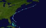
Tropical cyclogenesis began in May, with Alma developing on May 17. A short-lived tropical depression also formed that month. In June, two tropical depression developed, but never became a tropical storm. Three systems originated in July, including Tropical Storm Becky, the depression that would eventually intensify into Hurricane Celia, and another tropical depression that remained below tropical storm intensity.[5] Celia became the most intense tropical cyclone of the season on August 3, peaking as a Category 3 hurricane on the Saffir–Simpson scale with maximum sustained winds of 125 mph (205 km/h) and a minimum barometric pressure of 945 mbar (27.9 inHg).[1] In August, four tropical systems developed, including an unnamed tropical storm, Dorothy, and two other tropical depressions. September featured tropical depressions, though only three became named storms – Ella, Felice, and Greta.[5] Two unnamed hurricanes developed in October, the second of which became an extratropical cyclone on October 28.[1]
The season's activity was reflected with an accumulated cyclone energy (ACE) rating of 40.[6] ACE is, broadly speaking, a measure of the power of the hurricane multiplied by the length of time it existed, so storms that last a long time, as well as particularly strong hurricanes, have high ACEs. It is only calculated for full advisories on tropical systems at or exceeding 39 mph (63 km/h), which is tropical storm strength.[7]
Storms
Hurricane Alma
| Category 1 hurricane (SSHWS) | |||
|---|---|---|---|
| |||
| Duration | May 17 – May 26 | ||
| Peak intensity | 80 mph (130 km/h) (1-min) 993 mbar (hPa) | ||


An area of disturbed weather persisted over the southwestern Caribbean Sea in the middle of May. It gradually organized, [8] and a tropical depression formed on May 17.[1] In response to low shear aloft and warm water temperatures,[8] the depression rapidly strengthened on May 20, becoming a storm early in the day and a hurricane by night. However, Alma quickly weakened back to a tropical storm on May 21. Furthermore, it weakened to a tropical depression on the following day,[1] mostly due to upper-level shear.[8] The depression continued its general northward movement, with a brief jog to the west, and hit Cuba on May 24 as a 30 mph (48 km/h) tropical depression.[1] As Alma crossed the eastern Gulf of Mexico, it retained a very well defined circulation with an eye appearing on radar, but shear limited convection and strength.[8]
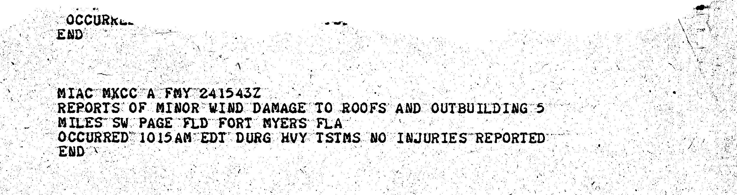
Alma made landfall near Cedar Key, Florida, on May 25 as a tropical depression and became extratropical two days later over North Carolina.[1] Although Alma passed just offshore, impact in Central America, if any, is unknown.[8] In the Cayman Islands, winds of 65 mph (105 km/h) was reported.[9] Impact was severest in Cuba, where flash flooding caused seven fatalities,[8][10] destroyed several homes, forced the evacuation of 3,000 people in Oriente Province, and resulted in a shutdown of 16 sugar mills.[10] The storm brought light rainfall to Florida, peaking at 6.66 in (169 mm) near Miami.[11] Hazardous thunderstorms caused one death in Miami and damaged some roofs and building in Fort Myers.[12][13] In other states, impact was mostly in the form of rain, though a tornado near Columbia, South Carolina, destroyed a roof.[14]
Tropical Storm Becky
| Tropical storm (SSHWS) | |||
|---|---|---|---|
| |||
| Duration | July 19 – July 23 | ||
| Peak intensity | 65 mph (100 km/h) (1-min) 1003 mbar (hPa) | ||
.JPG)

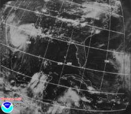
A large disturbance began to detach from the Intertropical Convergence Zone near Panama on July 16. It is possible that the disturbance interacted with a low-level vortex over the northwest Caribbean Sea.[8] By July 19, the disturbance developed into a tropical depression. After tracking through the Yucatan Channel, the depression became Tropical Storm Becky on July 20. Becky tracked northward to north-northeastward across the Gulf of Mexico and eventually strengthened to reach peak winds of 65 mph (105 km/h) late on July 20.[1] Thereafter, upper level winds began weakening the storm.[1][8] By July 22, Becky made landfall near Port St. Joe, Florida, as either a minimal tropical storm or a tropical depression. The storm weakened further over land, eventually dissipating over western Kentucky on the July 23.[1]
Throughout the state of Florida, Becky produced mostly light rainfall and gale force winds. However, in Tallahassee, the storm dropped more than 8 in (200 mm) of rain, which caused flooding in and round the city.[8] According to the Red Cross, 104 families in the Tallahassee region suffered flood-related losses. Additionally, two injuries were reported.[15] Some houses near Tallahassee were flooded with 4 ft (1.2 m) of water, resulting in the evacuation of 15 households by rowboat. More than 100 cars in the area were also flooded.[16] In nearby Wakulla County, knee-deep waters were reported at the county courthouse at Crawfordville.[15] Additionally, a tornado spawned near Panacea, destroyed a house and damaged two others. Outside of Florida, effects were mainly limited to light to moderate rainfall, though a tornado in Georgia caused one fatality and destroyed two homes.[8]
Hurricane Celia
| Category 3 hurricane (SSHWS) | |||
|---|---|---|---|
| |||
| Duration | July 31 – August 5 | ||
| Peak intensity | 125 mph (205 km/h) (1-min) 945 mbar (hPa) | ||

A tropical wave emerged into the Atlantic Ocean from the west coast of Africa on July 23. It moved rapidly western and reached the western Caribbean Sea by July 30.[8] On the following day, the system developed into a tropical depression near Grand Cayman. The depression tracked north-northwestward without significantly strengthening and struck crossed western Cuba on August 1.[1] Heavy rains on the island caused severe flooding, leading to five fatalities.[8] The depression entered the Gulf of Mexico and was upgraded to Tropical Storm Celia later on August 1.[1] Due to warm sea surface temperatures,[8] Celia rapidly intensified into a Category 3 hurricane on August 1.[1] Storm surge and swells lashed the west coast of Florida, especially the Panhandle. Several life guard rescues occurred, while eight people drowned.[17]
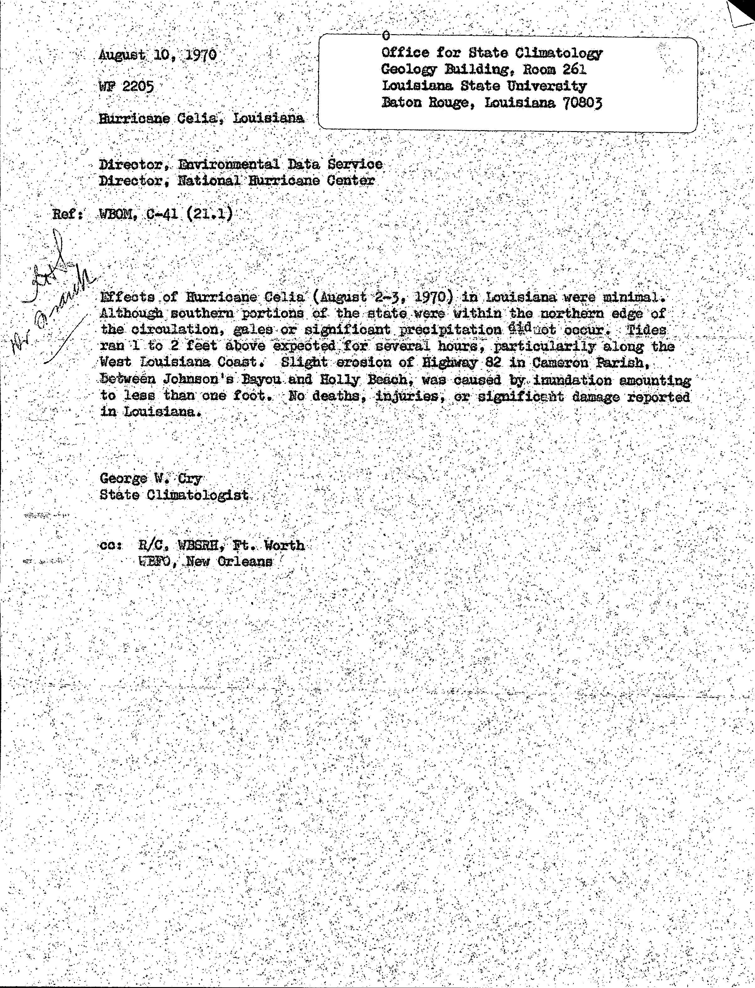
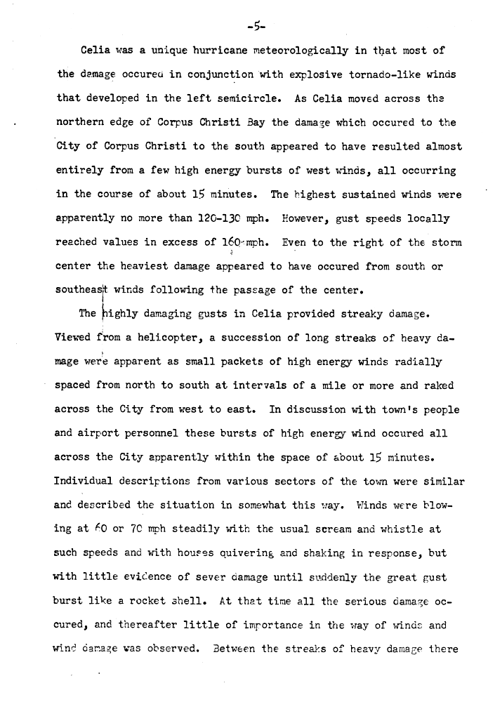
Early on August 2, Celia began to weaken and fell to Category 2 intensity. The storm weakened further to a Category 1 hurricane on August 3. However, while approaching the Texas coastline later that day, Celia began to rapidly intensify again. At 1800 UTC on August 3, Celia attained its peak intensity with maximum sustained winds of 125 mph (205 km/h) and a minimum barometric pressure of 945 mbar (27.9 inHg).[1] In Louisiana, tides caused minor coastal flooding.[18] Late on August 3, Celia made landfall near Corpus Christi, Texas.[1] In Nueces County, wind gusts as high as 180 mph (290 km/h) were observed.[17] Severe damage occurred in the county, with 85% of Celia's total property losses caused in Corpus Christi alone. Approximately 90% of downtown buildings were damaged or destroyed, while about one-third of homes in the city suffered severe impact or were demolished.[17] Throughout the state, 8,950 homes were destroyed and damaged about 55,650 others. About 252 small businesses, 331 boats, and 310 farm buildings were either damaged or destroyed.[19] In Texas alone, Celia caused 15 deaths and $930 million in damage.[20] Celia weakened while moving further inland and dissipated over New Mexico on August 6.[1]
Tropical Storm Four
| Tropical storm (SSHWS) | |||
|---|---|---|---|
| |||
| Duration | August 7 – August 18 | ||
| Peak intensity | 70 mph (110 km/h) (1-min) 992 mbar (hPa) | ||
.JPG)
A tropical wave quickly developed into a tropical depression offshore Senegal on August 7. The depression moved generally westward and did not strengthen significantly. By August 11, it curved west-northwestward and degenerated into an open trough on August 12, while well east of the Lesser Antilles.[5] However, the remnants re-developed into a tropical depression about 95 mi (155 km) east-northeast of the Abaco Islands in the Bahamas at 12:00 UTC on August 15. Initially, the depression continued moving west-northwestward, before turning northward early the following day. Around 06:00 UTC on August 16, the system made landfall near Beaufort, North Carolina, with winds of 35 mph (55 km/h). After re-emerging into the Atlantic early on August 18, the depression moved northeastward and intensified into a tropical storm. The ship Hotel observed sustained winds of 65 mph (100 km/h) around that time. At 18:00 UTC, the storm peaked with winds of 70 mph (110 km/h) and a minimum pressure of 992 mbar (29.3 inHg). Shortly thereafter, the cyclone became extratropical about 180 mi (290 km) east of Sable Island.[1]
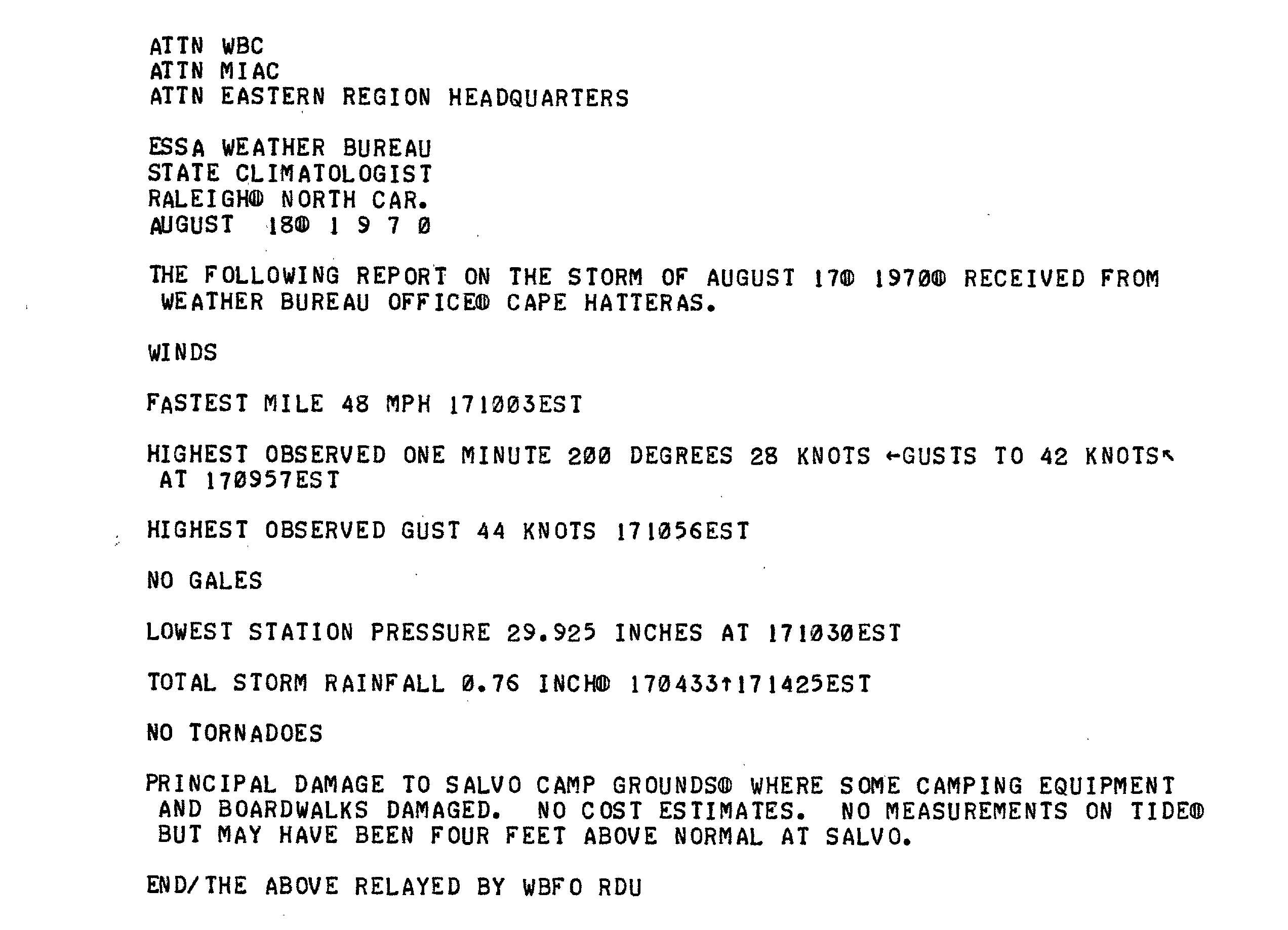
Along the coast of North Carolina, higher than normal tides capsized about 20 boats, including a 68 ft (21 m) yacht.[17] At Salvo, where the tide may have reached 4 ft (1.2 m) above normal, boardwalks and camping equipment were damaged at the campgrounds. Heavy squalls produced winds as strong as 75 mph (120 km/h) in Atlantic Beach.[21] Minor wind damage was reported in Atlantic Beach and Morehead City, primarily limited to some trees, power lines, roof shingles, television antennas, and signs.[21][22] From North Carolina to Maryland, lifeguards made dozens of rescues.[23] Four drowning deaths occurred, with two in North Carolina and two in Virginia.[22][23][24]
Tropical Storm Dorothy
| Tropical storm (SSHWS) | |||
|---|---|---|---|
| |||
| Duration | August 17 – August 23 | ||
| Peak intensity | 70 mph (110 km/h) (1-min) 996 mbar (hPa) | ||
.jpg)

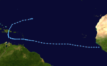
A tropical wave moved off the western coast of Africa on August 13. Moving westward,[25] a tropical disturbance spawned by the wave led to the formation of a tropical depression beginning 500 mi (800 km) east of the Lesser Antilles on August 17. As it moved west-northwestward, it slowly intensified, and was upgraded to Tropical Storm Dorothy on August 19. By the following day, Dorothy attained its peak intensity with maximum sustained winds of 70 mph (110 km/h). Around that time, Dorothy crossed the island of Martinique. After passing through the Lesser Antilles, Dorothy moved under an upper-level cold-core trough, which caused the storm to weaken. On August 23, Dorothy dissipated south of the Tiburon Peninsula of Haiti.[26]
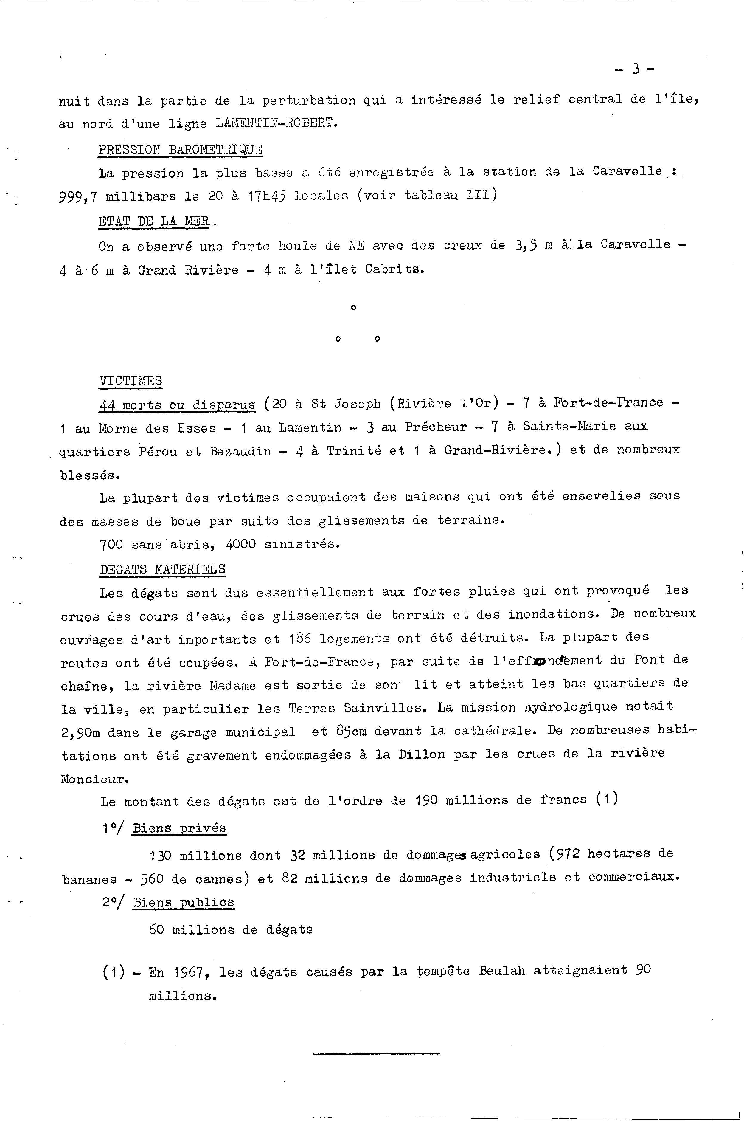
Throughout the Lesser Antilles, Dorothy produced high winds and heavy rainfall. On Martinique, large amounts of precipitation resulted in flooding and mudslides, which in turn, caused bridge collapses and damage to homes.[27] In addition, strong tropical storm force winds were also reported on the island. The storm destroyed 186 homes and left 700 people homeless.[28] Severe crop damage also occurred, especially to bananas and sugar cane. Flooding also occurred on Dominica and Guadeloupe, although effects were less severe.[27][29] The exact death toll of Dorothy is unknown, although some sources claim that as many as 51 fatalities occurred.[26] Dorothy also caused $34 million in damage.[27]
Hurricane Ella
| Category 3 hurricane (SSHWS) | |||
|---|---|---|---|
| |||
| Duration | September 8 – September 13 | ||
| Peak intensity | 125 mph (205 km/h) (1-min) 967 mbar (hPa) | ||


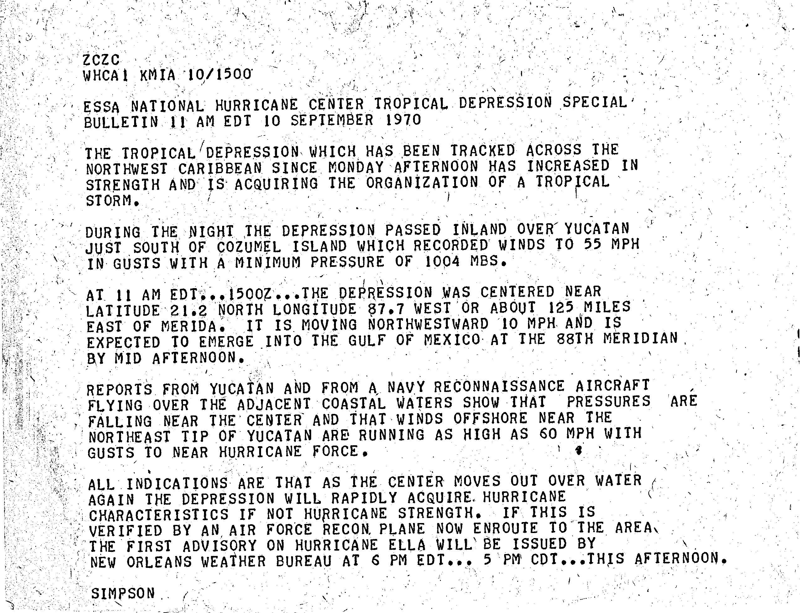
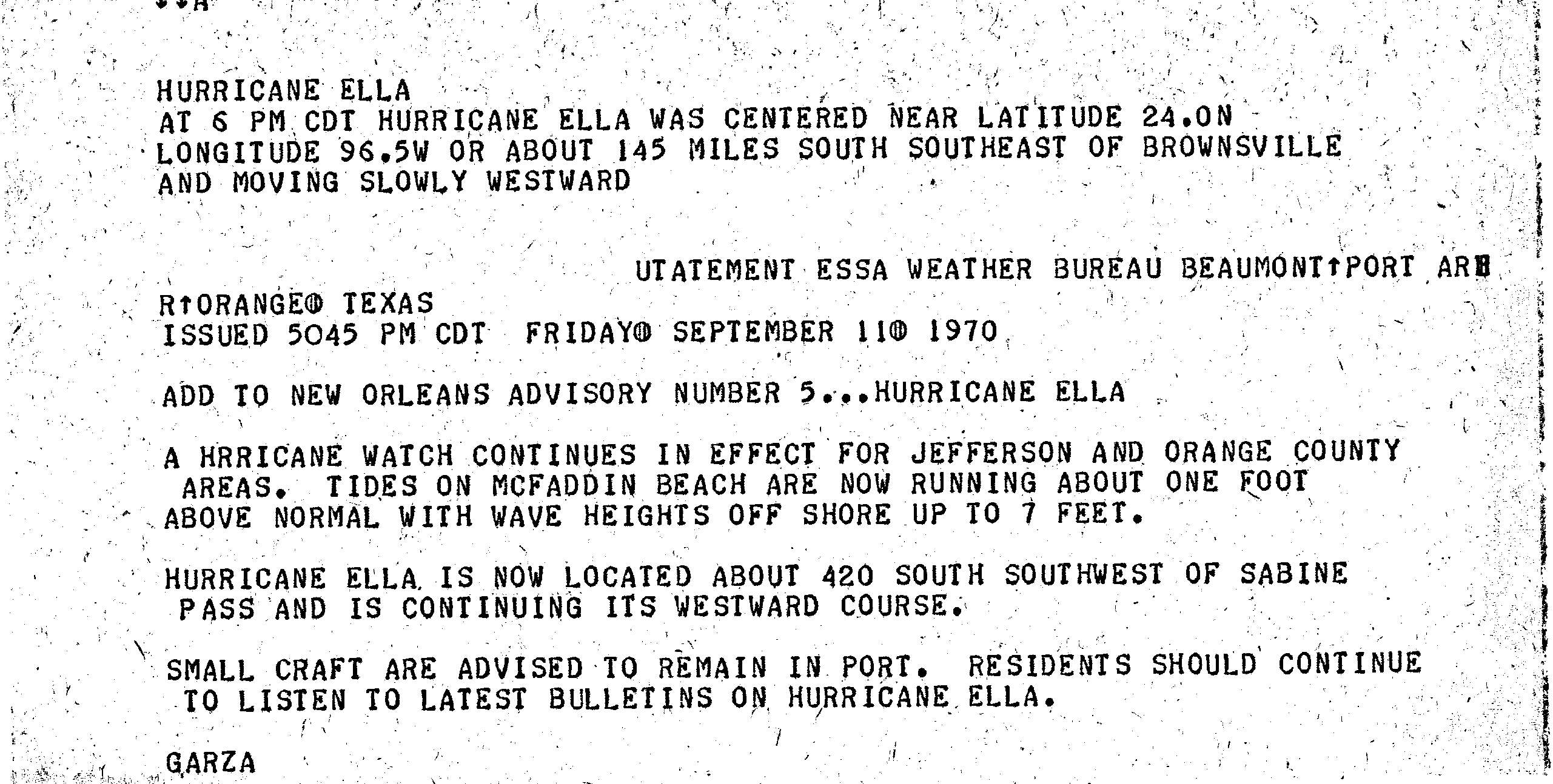
A surface trough spawned a tropical depression near Cabo Gracias a Dios, Honduras, on September 8.[1][8] The depression moved northwestward without intensifying before striking Tulum, Quintana Roo, on September 10. Hours later, the system emerged into the Gulf of Mexico and soon strengthened into Tropical Storm Ella.[1] A ridge to the north caused it to curve in a general westward direction.[8] Just six hours after becoming a tropical storm, Ella intensified into a hurricane early on September 11. While approaching the Gulf Coast of Mexico, the cyclone deepened significantly, peaking as a Category 3 hurricane on September 12 with winds of 125 mph (205 km/h) and a minimum pressure of 967 mbar (28.6 inHg). Shortly thereafter, Ella made landfall near La Pesca, Tamaulipas, at the same intensity. The hurricane rapidly weakened inland, falling to tropical storm intensity on September 13 and dissipating several hours later.[1]
In the Yucatan Peninsula, wind gusts of 55 mph (90 km/h) were observed.[30] Ella brought heavy rainfall to portions of northeastern Mexico.[31] Several homes were destroyed and villages along the San Marcos River were inundated by water.[32] One girl died after her house collapsed. Flooding and persist precipitation prevented the transportation of relief items, including food and medicine, by helicopters.[33] In Texas, tides peaked at 7 ft (2.1 m) normal, but no coastal flooding damage was reported.[34]
Tropical Storm Felice
| Tropical storm (SSHWS) | |||
|---|---|---|---|
| |||
| Duration | September 12 – September 17 | ||
| Peak intensity | 70 mph (110 km/h) (1-min) 997 mbar (hPa) | ||
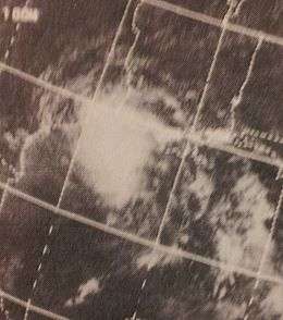

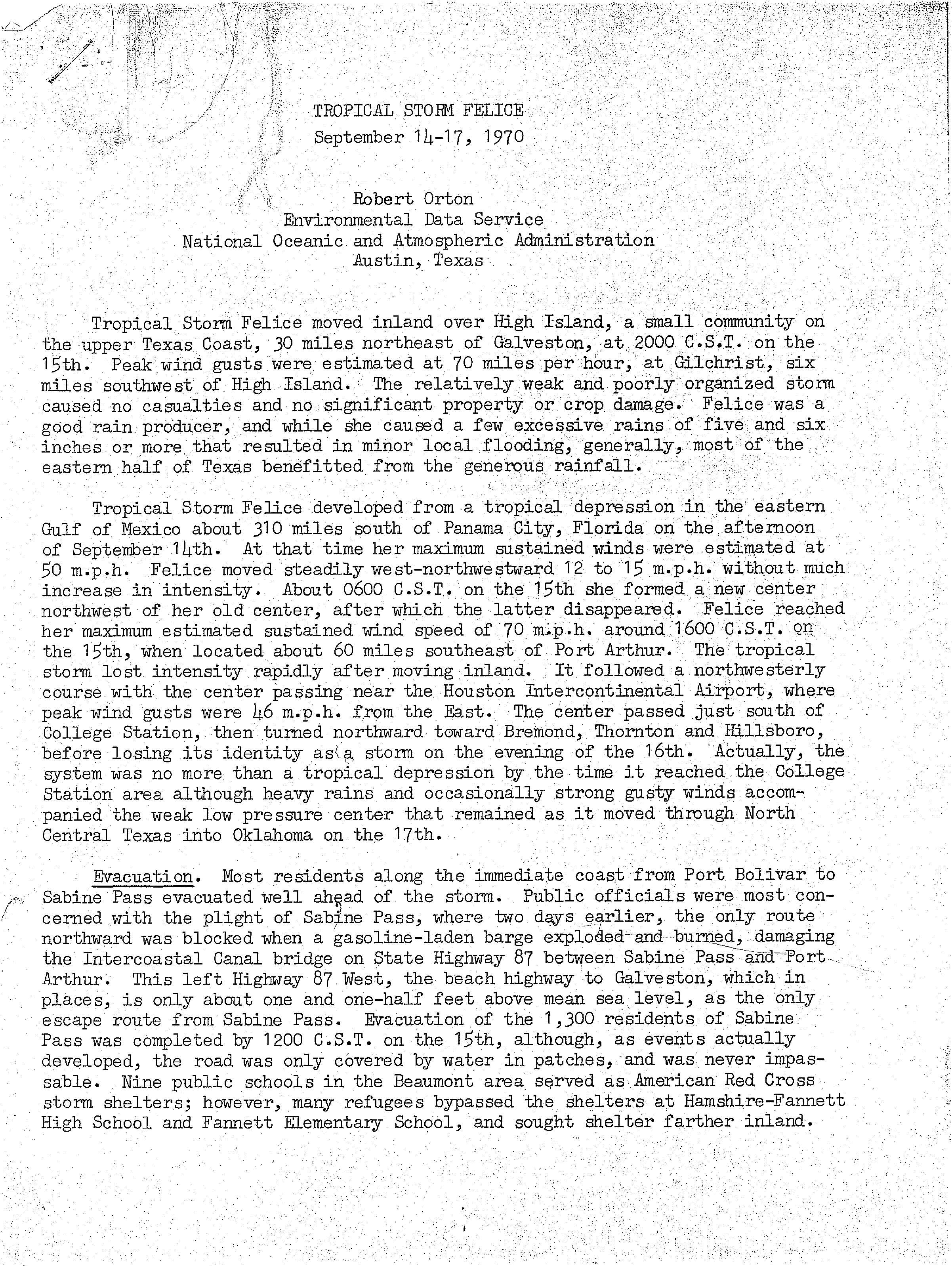
On September 12, a tropical depression developed from an upper-level trough just south of Abaco Islands.[8] Without significant intensification, the system crossed the Florida Keys and entered the Gulf of Mexico.[1] Felice remained a disorganized storm for its entire duration, plagued by dry air, a lack of deep thunderstorm activity, and an ill-defined center of circulation.[8] However, early on September 16, the cyclone peaked with maximum sustained winds of 70 mph (110 km/h) and a minimum barometric pressure of 997 mbar (29.4 inHg). Felice tracked northwestward and brushed southern Louisiana on September 15, before making landfall near Galveston, Texas, later that day. Once ashore, Felice quickly deteriorated as it recurved into the central United States, dissipating on September 17.[1] While over southeastern Oklahoma, however, its remnants still closely resembled a formidable tropical cyclone.[35]
In advance of the cyclone, officials advised residents in vulnerable communities to evacuate their homes,[36] and temporary storm shelters were established.[37] However, the effects from Felice were generally light. Beneficial rains fell over parts of southern Florida,[38] while sections of coastal Louisiana experienced minimal gale-force winds and above-normal tides.[39] In Texas, winds gusting to 55 mph (89 km/h) at Galveston—and estimated near 70 mph (110 km/h) elsewhere—caused scattered power outages and minor tree damage,[40] while heavy rainfall totaling over 6 in (150 mm) triggered some street flooding.[11][40] Felice delayed the local rice harvest and damaged some hay that had been cut before the storm.[40] Significant precipitation and gusty winds accompanied the system into northern Texas and Oklahoma.[35]
Tropical Depression Nineteen
| Tropical depression (SSHWS) | |||
|---|---|---|---|
| |||
| Duration | September 23 – October 11 | ||
| Peak intensity | 35 mph (55 km/h) (1-min) 1000 mbar (hPa) | ||

The long-lived depression formed on September 24 just off the west coast of Africa, and for several days maintained a general westward track. It passed through the Lesser Antilles on October 1, and later stalled in the eastern Caribbean Sea. On October 8, the depression crossed over the eastern portion of the Dominican Republic, and subsequently it accelerated to the northeast. It was declassified as a tropical cyclone on October 12, although its remnants persisted for another week before dissipating in the westerlies near the Azores.[1][5]
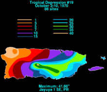
The depression produced heavy rainfall in the Lesser Antilles, reaching 12 in (300 mm) on Barbados;[41] it left three deaths and moderate damage on the island.[42] Another death was reported in the United States Virgin Islands. Torrential rainfall in Puerto Rico inflicted heavy damage, totaling $65 million.[5] The highest precipitation total was 41.68 in (1,059 mm) in Jayuya,[11] of which 17 in (430 mm) fell in a 24‑hour period.[5] Most of the damage can be attributed to damaged sugar cane and coffee crops.[43] At least 18 people were killed on the island,[5] and the system was considered one of the worst disasters in Puerto Rican history.[44]
Tropical Storm Greta
| Tropical storm (SSHWS) | |||
|---|---|---|---|
| |||
| Duration | September 26 – October 5 | ||
| Peak intensity | 50 mph (85 km/h) (1-min) 1004 mbar (hPa) | ||


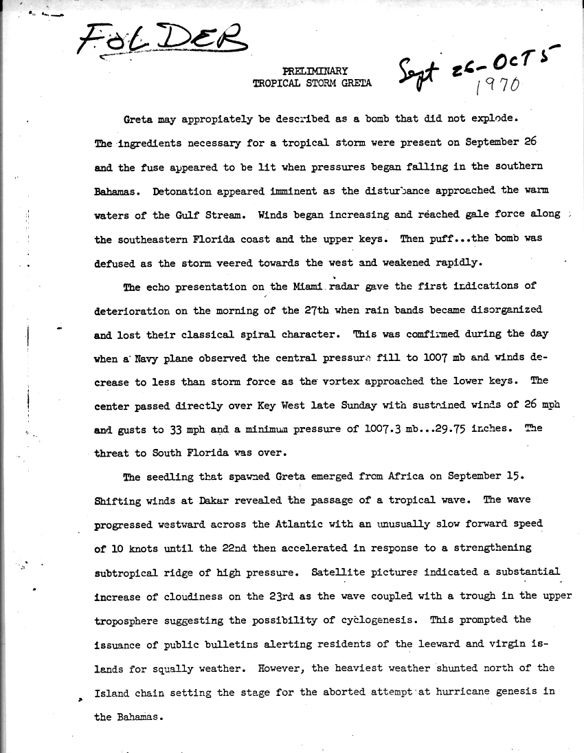
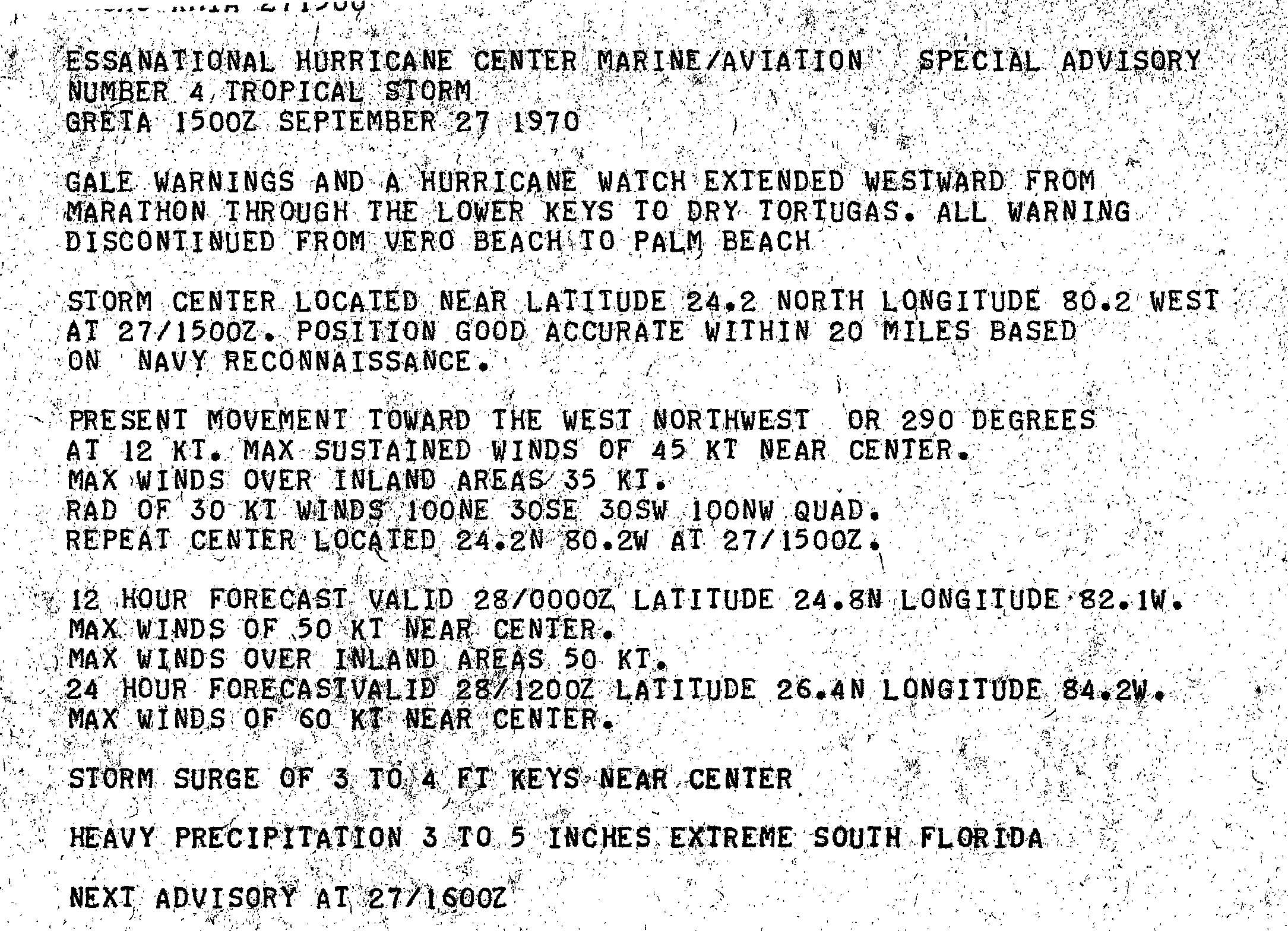
A tropical wave exited western Africa and emerged into the Atlantic Ocean on September 15. Initially, it moved slowly westward, until September 22, when a high-pressure area caused it to accelerate west-northwestward towards the Leeward Islands.[25] By the next day, the wave interacted with a cold-core low, producing an area of convection. As the system moved over warmer waters, gale-force winds were measured. Because a surface low formed on September 26,[45] the system was then designated as Tropical Storm Greta. However, the storm did not strengthen, despite favorable conditions, and as a result, it was described as a "bomb that did not explode".[8][46]
While approaching the Florida Keys, Greta abruptly weakened to a tropical depression, coinciding with deterioration of the cloud pattern. In addition, Hurricane Hunters reported rising pressures and lower winds. On the evening of September 27, Greta made landfall in Key West, Florida with sustained winds of 26 mph (42 km/h).[46] Once in the Gulf of Mexico, Greta did not re-intensify, though it retained a closed circulation while moving around a high-pressure area. It moved across the northern Yucatán Peninsula, though it quickly re-emerged into the Gulf of Mexico. Eventually, Greta made landfall near Tampico, Mexico on October 5, and dissipated shortly thereafter.[8] Due to the weak nature of the storm, minimal impact was reported. In Florida, tides were generally minor, and were no more than 3 and 4 feet (0.91 and 1.22 m) in height, as reported in the Florida Keys.[47] Rainfall was mostly light, peaking at 8.94 in (227 mm) in Fort Pierce.[45]
Hurricane Nine
| Category 2 hurricane (SSHWS) | |||
|---|---|---|---|
| |||
| Duration | October 12 – October 17 | ||
| Peak intensity | 105 mph (165 km/h) (1-min) 974 mbar (hPa) | ||
.JPG)

On October 12, a subtropical depression developed while located northeast of the Bahamas. It steadily intensified and became a subtropical storm by the following day. After tracking east-northeastward, the storm made a sharp westward turned, followed by a curved to the north-northeast. After fully acquiring tropical characteristics, the subtropical storm transitioned into a tropical cyclone early on October 16. Twelve hours later, the storm strengthened into a hurricane,[1] shortly before passing near Bermuda.[48] It continued to intensify and briefly became a Category 2 hurricane on October 17. The hurricane then accelerated rapidly northeastward,[1] and made landfall on the Avalon Peninsula of Newfoundland as a Category 1 hurricane. Shortly thereafter, the hurricane transitioned into an extratropical cyclone on October 17.[1][49]
The hurricane produced high winds on Bermuda, causing suspension schools, transportation, and interrupted businesses, though minimal damage occurred.[50] In addition, light rainfall fell on the island.[11] Throughout Newfoundland, hurricane-force winds were reported, which caused damage to structures, though mostly limited to broken windows. Rough seas along the Atlantic coast of the island damaged fishing dories and a fishing ramp. Heavy rainfall was also reported in the region, reaching nearly 5 in (130 mm) in Quebec. Damage on the Burin Peninsula was in the thousands, although the specific figure is unknown. On the French Territory of Saint Pierre and Miquelon, several buildings lost their roof due to high winds.[49]
Hurricane Ten
| Category 1 hurricane (SSHWS) | |||
|---|---|---|---|
| |||
| Duration | October 20 – October 28 | ||
| Peak intensity | 75 mph (120 km/h) (1-min) 988 mbar (hPa) | ||

A subtropical depression developed about 970 mi (1,560 km) east-northeast of Bermuda at 12:00 UTC on October 20. After intensifying into a subtropical storm early the following day, further strengthening was slow. Initially, the system northeastward, but curved southeastward on October 24. During that time, it began acquiring characteristics of a tropical cyclone, transitioning into a tropical storm at 12:00 UTC. The storm resumed its northeastward motion and continued to intensify. Early on October 27, the storm strengthened into a hurricane,[1] based on a report of winds of 75 mph (120 km/h) from the Pretoria several hours later. At the time of hurricane intensity, it is likely that the hurricane-force wind field was only 6 mi (9.7 km) in diameter and its tropical storm force wind field was only 69 mi (111 km) in diameter.[8] By 12:00 UTC on October 27, the cyclone weakened to a tropical storm and began accelerating. About 24 hours later, the system transitioned into an extratropical cyclone while situated approximately 500 mi (800 km) north-northeast of Graciosa in the Azores.[1]
Other storms
In addition to the ten named storms of 1970 and the notable Tropical Depression Nineteen, there were several minor systems that were also classified as depressions by the National Hurricane Center. The second tropical depression of the season (after Hurricane Alma) developed to the northeast of the Lesser Antilles on May 20. It moved north-northeastward without significant intensification and dissipated on the following day. Another tropical depression developed on June 19, while located about halfway between Cape Hatteras and Puerto Rico. It tracked northeastward in the general direction of Bermuda, but dissipated on June 20. A tropical wave emerged into the Atlantic from the west coast of Africa, while the previous tropical depression was dissipating. After tracking uneventfully across the Atlantic and much of the Caribbean Sea, the wave developed into a tropical depression north of Panama on June 30. Later that day, the depression made landfall near the Nicaragua-Costa Rica border. Although the depression dissipated within 24 hours later, the remnants redeveloped into Hurricane Francesca in the Pacific Ocean by July 1. A tropical depression developed offshore of North Carolina on July 27. Initially, the depression tracked toward the Outer Banks, but veered east-southeastward and avoided landfall. While nearing Bermuda on July 30, the depression slowly curved north-northeastward. By early on August 2, the depression dissipated while located east of Cape Race, Newfoundland.[5]
Tropical Depression Nine developed on the same day in the vicinity of Cape Verde. It moved west-northwestward across the eastern-North Atlantic Ocean and eventually curved nearly due eastward. The depression dissipated about halfway between Puerto Rico and the west coast of Africa on August 6. While Tropical Depression Nine was dissipating in the open Atlantic on August 4, Tropical Depression Ten developed near the Bahamas. By the following day, the depression made landfall near Palm Bay, Florida, and dissipated early on August 7. Another system formed northeast of Cape Verde on August 11. It tracked generally westward for the next several days and ceased to be a cyclone on August 18, while just north of the Lesser Antilles. The next depression originated about halfway between the Lesser Antilles and Cape Verde on September 3. The system moved west-southwestward for much of its duration and dissipated by September 9. Another tropical depression began just offshore Dakar, Senegal, on September 5. It crossed through Cape Verde before dissipating on September 7. Later that month, the next system formed just east of Cape Verde on September 22. The depression dissipated on September 25, after moving northwestward across the far eastern Atlantic. On September 29, a system developed about 400 mi (640 km) southeast of Bermuda. The depression moved rapidly north-northeastward and dissipated about 280 mi (450 km) south of Cape Race, Newfoundland, on October 1.[5]
Storm names
The following names were used for named storms (tropical storms and hurricanes) that formed in the North Atlantic in 1970.[2] A storm was named Felice for the first time in 1970. Names that were not assigned are marked in gray.
|
|
Retirement
The name Celia was later retired and replaced by Carmen in the 1974 Atlantic hurricane season.[51]
See also
- List of Atlantic hurricanes
- List of Atlantic hurricane seasons
- 1970 Pacific hurricane season
- 1970 Pacific typhoon season
- 1970 North Indian Ocean cyclone season
- Southern Hemisphere tropical cyclone seasons: 1969–70, 1970–71
References
- 1 2 3 4 5 6 7 8 9 10 11 12 13 14 15 16 17 18 19 20 21 22 23 24 25 26 27 28 29 30 31 32 33 National Hurricane Center; Hurricane Research Division (July 6, 2016). "Atlantic hurricane best track (HURDAT version 2)". United States National Oceanic and Atmospheric Administration. Retrieved December 5, 2016.
- 1 2 3 Joseph L. Myler (January 2, 1970). "Release list of names for 1970 hurricanes". Ames Tribune. Washington, D.C. United Press International. p. 1966. Retrieved September 6, 2016 – via Newspapers.com.

- 1 2 3 Philip J. Klotzbach and William M. Gray (December 8, 2006). Extended Range Forecast of Atlantic Seasonal Hurricane Activity and U.S. Landfall Strike Probability for 2007 (Report). Boulder, Colorado: Colorado State University. Archived from the original on 18 December 2006. Retrieved March 28, 2014.
- ↑ Robert H. Simpson and Joseph M. Pelissier (April 1971). "Atlantic Hurricane Season of 1970" (PDF). Monthly Weather Review. American Meteorological Society. 99 (4). Bibcode:1971MWRv...99..269S. doi:10.1175/1520-0493(1971)099<0269:AHSO>2.3.CO;2. Retrieved September 6, 2016.
- "Seven Cubans Drown in Floods of Alma". The Miami News. May 1970.
- Deaths from Hurricane Alma (Report). National Hurricane Center. 1970. Retrieved November 19, 2015.
- Robert H. Simpson (March 14, 1971). Preliminary Report Celia. National Hurricane Center (Report). Miami, Florida: National Oceanic and Atmospheric Administration. p. 2. Retrieved September 6, 2016.
- The Deadliest, Costliest, and Most Intense United States Tropical Cyclones from 1851 to 2010 (and other frequently requested hurricane facts) (PDF). National Climatic Data Center, National Hurricane Center (Report). National Oceanic and Atmospheric Administration. August 10, 2011. p. 47. Retrieved November 28, 2015.
- Storm Data and Unusual Weather Phenomena: August 1970 (PDF). National Climatic Data Center (Report). National Oceanic and Atmospheric Administration. 1970. p. 119. Archived from the original (PDF) on November 28, 2015. Retrieved November 28, 2015.
- Preliminary Report: Tropical Storm Dorothy – August 13-23, 1970 (Report). National Hurricane Center. 1970. p. 1. Retrieved September 5, 2016.
- "Say Dorothy Killed 15 On Islands". United Press International. August 21, 1970.
- "Weather". Edmonton Journal. Associated Press. September 15, 1970. Retrieved November 28, 2015.
- Office of U.S. Foreign Disaster Assistance (August 1993). Significant Data on Major Disasters Worldwide 1990-present (PDF) (Report). Retrieved September 5, 2016.
- Neil L. Frank (April 1971). "Atlantic Tropical Systems of 1970" (PDF). Monthly Weather Review. American Meteorological Society. 99 (4): 269–277. Bibcode:1971MWRv...99..281F. doi:10.1175/1520-0493(1971)099<0281:ATSO>2.3.CO;2. Retrieved September 6, 2016.
- 1970-NN-2 (Report). Environment Canada. May 5, 2011. Retrieved September 3, 2011.
- 1 2 3 4 5 6 7 8 9 Neil L. Frank (April 1971). "Atlantic Tropical Systems of 1970" (PDF). Monthly Weather Review. American Meteorological Society. 99 (4): 269–277. Bibcode:1971MWRv...99..281F. doi:10.1175/1520-0493(1971)099<0281:ATSO>2.3.CO;2. Retrieved September 6, 2016.
- ↑ Atlantic basin Comparison of Original and Revised HURDAT. Hurricane Research Division; Atlantic Oceanographic and Meteorological Laboratory (Report). National Oceanic and Atmospheric Administration. March 2011. Retrieved March 6, 2012.
- ↑ David Levinson (August 20, 2008). 2005 Atlantic Ocean Tropical Cyclones. National Climatic Data Center (Report). National Oceanic and Atmospheric Administration. Retrieved March 6, 2012.
- 1 2 3 4 5 6 7 8 9 10 11 12 13 14 15 16 17 18 19 20 Robert H. Simpson and Joseph M. Pelissier (April 1971). "Atlantic Hurricane Season of 1970" (PDF). Monthly Weather Review. American Meteorological Society. 99 (4). Bibcode:1971MWRv...99..269S. doi:10.1175/1520-0493(1971)099<0269:AHSO>2.3.CO;2. Retrieved September 6, 2016.
- ↑ Observations from the Cayman Islands (Report). National Hurricane Center. 1970. Retrieved November 19, 2015.
- 1 2 "Seven Cubans Drown in Floods of Alma". The Miami News. May 1970.
- 1 2 3 4 Roth, David M. (April 29, 2015). "Tropical Cyclone Point Maxima". Tropical Cyclone Rainfall Data. United States Weather Prediction Center. Retrieved May 8, 2016.
- ↑ Deaths from Hurricane Alma (Report). National Hurricane Center. 1970. Retrieved November 19, 2015.
- ↑ Reports of Minor Wind Damage (Report). National Hurricane Center. May 24, 1970. Retrieved November 19, 2015.
- ↑ "Alma Brings an End to the Drought". St. Petersburg Times. May 25, 1970. Retrieved November 19, 2015.
- 1 2 "Weakened Becky Drenches State". St. Petersburg Times. July 23, 1970. Retrieved November 28, 2015.
- ↑ "Little Damage in Florida Tornado". The Derrick. 1970.
- 1 2 3 4 Storm Data and Unusual Weather Phenomena: August 1970 (PDF). National Climatic Data Center (Report). National Oceanic and Atmospheric Administration. 1970. p. 119. Archived from the original (PDF) on November 28, 2015. Retrieved November 28, 2015.
- ↑ George W. Cry (August 10, 1970). Hurricane Celia, Louisiana. Louisiana State University (Report). National Oceanic and Atmospheric Administration, National Hurricane Center. Retrieved November 28, 2015.
- ↑ Preliminary Report Celia. National Hurricane Center (Report). Miami, Florida: National Oceanic and Atmospheric Administration. 1970. p. 5. Retrieved 2013-05-08.
- ↑ The Deadliest, Costliest, and Most Intense United States Tropical Cyclones from 1851 to 2010 (and other frequently requested hurricane facts) (PDF). National Climatic Data Center, National Hurricane Center (Report). National Oceanic and Atmospheric Administration. August 10, 2011. p. 47. Retrieved November 28, 2015.
- 1 2 ESSA Weather Bureau State Climatologist Raleigh, North Carolina. Weather Bureau Office Raleigh, North Carolina (Report). Raleigh, North Carolina. August 18, 1970. Retrieved September 6, 2016.
- 1 2 "Storm Pelts East Coast". The Holland Sentinel. Virginia Beach, Virginia. United Press International. August 17, 1970. p. 1. Retrieved September 6, 2016 – via Newspapers.com.
- 1 2 "Ocean Storm Leaves 2 Dead". Abilene Reporter-News. Norfolk, Virginia. Associated Press. August 17, 1970. p. 19. Retrieved September 6, 2016 – via Newspapers.com.
- ↑ "Sunny Weather Prevails Over Much of the Nation". Daily Herald. United Press International. August 17, 1970. p. 13. Retrieved September 6, 2016 – via Newspapers.com.
- 1 2 National Oceanic and Atmospheric Administration (January 1971). "1970 Atlantic hurricane season". Mariners Weather Log. Department of Commerce. 15 (1): 6.
- 1 2 Preliminary Report: Tropical Storm Dorothy – August 13-23, 1970 (Report). National Hurricane Center. 1970. p. 1. Retrieved September 5, 2016.
- 1 2 3 "Say Dorothy Killed 15 On Islands". United Press International. August 21, 1970.
- ↑ Marcell Perrusset and Pierre Bouguen (1970). La Tempête Tropicale Dorothy (Report) (in French). Direction de la Meteorologie Nationale: Météorologique du Groupe Antilles-Guyane. p. 4. Retrieved September 5, 2016.
- ↑ "Storm Dorothy Weakens, Still Poses Threat to Caribbean Sea Islands". United Press International. August 23, 1970.
- ↑ Robert H. Simpson (September 10, 1970). Tropical Depression Special Bulletin (Report). National Hurricane Center. Retrieved November 28, 2015.
- ↑ "Hurricane Ella powers way towards Mexican coastline". Edmonton Journal. Associated Press. September 12, 1970. Retrieved November 28, 2015.
- ↑ "Ella Misses U.S.". Youngstown Vindicator. Associated Press. September 12, 1970. Retrieved November 28, 2015.
- ↑ "Weather". Edmonton Journal. Associated Press. September 15, 1970. Retrieved November 28, 2015.
- ↑ Garza (September 11, 1970). Hurricane Ella. Weather Bureau Office Beaumont/Port Arthur, Texas (Report). National Hurricane Center. Retrieved November 28, 2015.
- 1 2 Edward A. Jessup (April 1971). "Picture of the Month: Tropical Storm Felice in Oklahoma" (PDF). Monthly Weather Review. Norman, Oklahoma: American Meteorological Society. 99 (4): 278–280. Bibcode:1971MWRv...99..278J. doi:10.1175/1520-0493(1971)099<0278:tsfio>2.3.co;2. Retrieved September 5, 2016.
- ↑ "Tropical Storm Nears Louisiana". The Toledo Blade. New Orleans, Louisiana. Associated Press. September 14, 1970. Retrieved September 5, 2016.
- ↑ Robert Orton. Tropical Storm Felice: September 14–17, 1970 (Report). Austin, Texas: Environmental Data Service. Retrieved September 5, 2016.
- ↑ Charles R. Condon (1970). Climatological data: National summary; Tropical Storm Felice, Sept. 11–17, 1970. Environmental Data Service. National Oceanic and Atmospheric Administration. p. 469. Retrieved September 5, 2016.
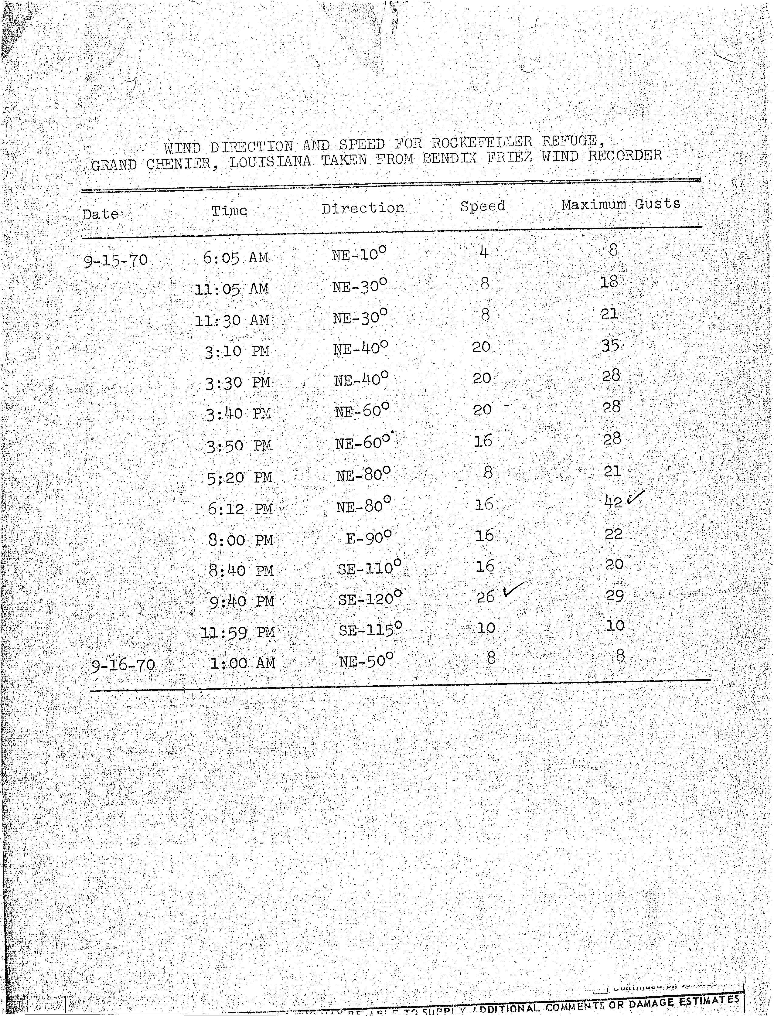
- ↑ Wind Direction and Speed for Rockefeller Refuge, Grand Chenier, Louisiana Taken from Bendix Friez Wind Recorded (Report). National Hurricane Center. Retrieved September 5, 2016.
- 1 2 3 Robert Orton. Tropical Storm Felice: September 14–17, 1970 (Report). Environmental Data Service. p. 2. Retrieved September 5, 2016.
- ↑ "Heavy Floods Hit Puerto Rico". Calgary Herald. San Juan, Puerto Rico. Associated Press. October 7, 1970. p. 18. Retrieved September 5, 2016.
- ↑ Office of U.S. Foreign Disaster Assistance (August 1993). Significant Data on Major Disasters Worldwide 1990-present (PDF) (Report). Retrieved September 5, 2016.
- ↑ "Puerto Rico Starts Flood Cleanup Job". Spokesman Review. San Juan, Puerto Rico. Associated Press. October 12, 1970. p. 5. Retrieved September 5, 2016.
- ↑ "Floods Kill 10 In Barbados, Puerto Rico". Morning Record. San Juan, Puerto Rico. Associated Press. October 8, 1970. p. 15. Retrieved September 5, 2016.
- 1 2 David M. Roth. Tropical Storm Greta - September 26-October 1, 1970 (Report). Camp Springs, Maryland: Weather Prediction Center. Retrieved September 6, 2016.
- 1 2 Preliminary: Tropical Storm Greta (Report). National Hurricane Center. p. 1. Retrieved September 6, 2016.
- ↑ National Hurricane Center Marine/Aviation Special Advisory Number 4 Tropical Storm Greta (Report). National Hurricane Center. Retrieved 2011-09-26.
- ↑ David Spiegler (December 1971). "The unnamed Atlantic Tropical Storms Of 1970" (PDF). Monthly Weather Review. National Oceanic and Atmospheric Administration. 99 (12). Bibcode:1971MWRv...99..966S. doi:10.1175/1520-0493(1971)099<0966:TUATSO>2.3.CO;2. Retrieved September 6, 2016.
- 1 2 1970-NN-2 (Report). Environment Canada. May 5, 2011. Retrieved September 3, 2011.
- ↑ "Winds Lash Bermudians". The Beaver County Times. United Press International. October 16, 1970. Retrieved March 24, 2012.
- ↑ Tropical Cyclone Naming History and Retired Names. National Hurricane Center (Report). National Oceanic and Atmospheric Administration. 2016. Retrieved September 6, 2016.
External links
Tropical cyclones of the 1970 Atlantic hurricane season | |||||||||||||||||||||||||||||||||||||||||||||||||||||
|---|---|---|---|---|---|---|---|---|---|---|---|---|---|---|---|---|---|---|---|---|---|---|---|---|---|---|---|---|---|---|---|---|---|---|---|---|---|---|---|---|---|---|---|---|---|---|---|---|---|---|---|---|---|
|
| ||||||||||||||||||||||||||||||||||||||||||||||||||||
| |||||||||||||||||||||||||||||||||||||||||||||||||||||