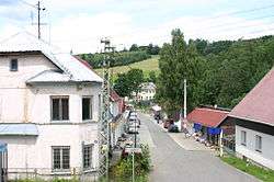
Český Jiřetín
| Český Jiřetín | |||
|---|---|---|---|
| Municipality | |||
 | |||
| |||
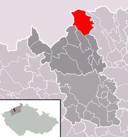 Location in Most District | |||
 Český Jiřetín Location in the Czech Republic | |||
| Coordinates: 50°41′28″N 13°33′38″E / 50.69111°N 13.56056°ECoordinates: 50°41′28″N 13°33′38″E / 50.69111°N 13.56056°E | |||
| Country |
| ||
| Region | Ústí nad Labem | ||
| District | Most | ||
| Area | |||
| • Total | 33.6 km2 (13.0 sq mi) | ||
| Elevation | 725 m (2,379 ft) | ||
| Population (2007) | |||
| • Total | 75 | ||
| • Density | 2.2/km2 (5.8/sq mi) | ||
| Postal code | 435 52 to 436 01 | ||
| Website | http://obecni-urad.net/source/index.php?ID=496 | ||

Český Jiřetín (German: Georgendorf) is a village and municipality (obec) in Most District in the Ústí nad Labem Region of the Czech Republic. The village is split across the Czech-German border - the German side is called Deutchgeorgenthal
The municipality covers an area of 33.6 square kilometres (13.0 sq mi), and has a population of 75 (as at 31 December 2007).
Český Jiřetín lies approximately 22 kilometres (14 mi) north of Most, 35 km (22 mi) west of Ústí nad Labem, and 91 km (57 mi) north-west of Prague.
References
| Wikimedia Commons has media related to Český Jiřetín. |
This article is issued from Wikipedia - version of the 4/7/2016. The text is available under the Creative Commons Attribution/Share Alike but additional terms may apply for the media files.