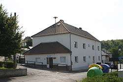
Patokryje
| Patokryje | |||
|---|---|---|---|
| Municipality | |||
 | |||
| |||
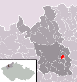 Location in Most District | |||
 Patokryje Location in the Czech Republic | |||
| Coordinates: 50°30′0″N 13°42′16″E / 50.50000°N 13.70444°ECoordinates: 50°30′0″N 13°42′16″E / 50.50000°N 13.70444°E | |||
| Country |
| ||
| Region | Ústí nad Labem | ||
| District | Most | ||
| Area | |||
| • Total | 2.62 km2 (1.01 sq mi) | ||
| Elevation | 221 m (725 ft) | ||
| Population (2006) | |||
| • Total | 412 | ||
| • Density | 160/km2 (410/sq mi) | ||
| Postal code | 435 21 | ||
| Website | http://www.patokryje.cz/ | ||
Patokryje (German Patokrey) is a village and municipality (obec) in Most District in the Ústí nad Labem Region of the Czech Republic.
The municipality covers an area of 2.62 square kilometres (1.01 sq mi), and has a population of 412 (as at 3 July 2006).
Patokryje lies approximately 5 kilometres (3 mi) east of Most, 30 km (19 mi) south-west of Ústí nad Labem, and 69 km (43 mi) north-west of Prague.
References
| Wikimedia Commons has media related to Patokryje. |
This article is issued from Wikipedia - version of the 9/12/2016. The text is available under the Creative Commons Attribution/Share Alike but additional terms may apply for the media files.