Township 1, Benton County, Arkansas
| Township 1 | |
|---|---|
| Township | |
 Township 1 Location in Arkansas | |
| Coordinates: 36°25′8″N 93°58′23″W / 36.41889°N 93.97306°WCoordinates: 36°25′8″N 93°58′23″W / 36.41889°N 93.97306°W | |
| Country |
|
| State |
|
| County | Benton |
| Area | |
| • Total | 33.6 sq mi (87 km2) |
| • Land | 33.6 sq mi (87 km2) |
| • Water | 0.0 sq mi (0 km2) 0% |
| Elevation | 1,380 ft (420 m) |
| Time zone | CST (UTC-6) |
| • Summer (DST) | CDT (UTC-5) |
| Area code(s) | 479 |
| GNIS feature ID | 1989186 |
| U.S. Geological Survey Geographic Names Information System: Township 1, Benton County, Arkansas | |
Township 1 is one of thirteen townships in Benton County, Arkansas, USA.[1]
Cities, towns, villages
- Avoca
- Beaver Shores
- Brightwater
- Buttry (historical)
- Clantonville
- Electric Springs (historical)
- Elkhorn Tavern
- Garfield
- Gateway
- Glade
- Hilltop
- Hurd (historical)
- Leetown (historical)
- Line Store (historical)
- Lost Bridge Valley
- Osborn
- Pippin (historical)
- Pleasant Valley
- Prairie Creek
- Puckett (historical)
- Rogers
- Vista Shores
- Walnut Hill
Cemeteries
The township contains Alpine Cemetery, Bayless Cemetery, Clantonville Cemetery, Dean Cemetery, Ford Cemetery, Liberty Cemetery, McReynolds Cemetery, Ozark Cemetery, Pratt Cemetery, Scott Cemetery, Snoderley Cemetery, Walnut Hill Cemetery, and Williams Cemetery. Two former cemeteries also exist: Henson Cemetery and Williams Cemetery.
Major routes
References
- United States Census Bureau 2008 TIGER/Line Shapefiles
- United States Board on Geographic Names (GNIS)
- United States National Atlas
- ↑ "Township 1, Benton County, Arkansas". U.S. Census Bureau. Retrieved 17 August 2011.
External links
 |
Township 7 | Ashley Township, Barry County, Missouri | Sugar Creek Township, Barry County, Missouri | |
| Township 6 Township 5 |
|
Beaver Township, Carroll County Cedar Township, Carroll County | ||
| ||||
| | ||||
| Township 3 | Township 2 | Packard Township, Carroll County |
Municipalities and communities of Benton County, Arkansas, United States | ||
|---|---|---|
| Cities | 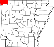 | |
| Towns | ||
| Townships | ||
| CDPs | ||
| Other communities |
| |
| Ghost town | ||
| Footnotes | ‡This populated place also has portions in an adjacent county or counties | |
This article is issued from Wikipedia - version of the 5/21/2016. The text is available under the Creative Commons Attribution/Share Alike but additional terms may apply for the media files.