Yeghvard
- For the town in Syunik province, see Yeghvard, Syunik.
Coordinates: 40°19′18″N 44°28′53″E / 40.32167°N 44.48139°E
| Yeghvard Եղվարդ | |
|---|---|
|
Yeghvard with Mount Ararat in the background | |
 Yeghvard Եղվարդ | |
| Coordinates: 40°19′18″N 44°28′53″E / 40.32167°N 44.48139°E | |
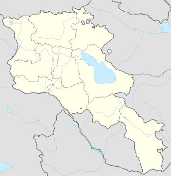
| Country | Armenia |
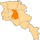
| Marz (Province) | Kotayk |
| First mentioned | 6th century |
| Government | |
| • Mayor | Norayr Sargsyan |
| Area | |
| • Total | 7 km2 (3 sq mi) |
| Elevation | 1,330 m (4,360 ft) |
| Population (2011 census) | |
| • Total | 11,672 |
| • Density | 1,700/km2 (4,300/sq mi) |
| Time zone | (UTC+4) |
| Website | Official website |
| Sources: Population[1] | |

Yeghvard (Armenian: Եղվարդ), is a town in Armenia within the Kotayk Province. It is located 39 kilometres southwest of the provincial centre Hrazdan. As of the 2011 census, the population of the town is 11,672, almost same as reported during the 2001 census.
Etymology
The word Yeghvard is derived from the merger of two Armenian words: Yeghi (Armenian: եղի) meaning odor or aroma, and vard (Armenian: վարդ) meaning rose. Thus, the word Yeghvard literally means rose odor. According to scholar and Armenologist Aram Ghanalanyan, the name is derived from the fact that the area of Yeghvard has been covered by a large forest, that was home to many types of roses and other flowers with strong fragrance and aroma.[2]
History
Yeghvard is one of the oldest settlements in Armenia. The name Yeghvard was first mentioned during the 6th century AD. It was first appeared in the historic chronicles of Catholicos Moses II of Yeghvard who reigned between 574 and 604 as the head of the Mother See of Holy Etchmiadzin. However, the area of Yeghvard has been settled since the beginning of the 2nd millennium BC, based on the remains of the "Seghanasar" ancient settlement found at the west of Yeghvard.
During the ancient Kingdom of Armenia, the area of modern-day Yeghvard was part of the "Kotayk" canton of Ayrarat province.
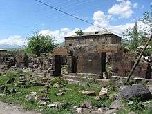
After the Christianization of Armenia in 301, the region of Kotayk became one of the important centres of the Armenian Church. The ruins of the Katoghike Church of Yeghvard are still found at the centre of the town. It was a large three-nave basilica built during the 5th and 6th centuries, under the rule of the Amatuni Armenian noble dynasty.

The remains of the 7th-century Saint Theodore Monastery -also known as Gharghavank of Zoravan- are found at the northeast of the town. According to the Catholicos of All Armenians John V the Historian, the monastic complex was built by prince Grigor I Mamikonian, between 666 and 685. Between the 7th and 9th centuries, Armenia suffered from the Arab Islamic occupation.
By the end of the 9th century, the village of Yeghvard became part of the newly-established Bagratid Kingdom of Armenia. Between the 11th and 15th centuries, Yeghvard suffered from the Seljuk, Mongol, Ag Qoyunlu and Kara Koyunlu invasions, respectively.

According to the Armenian historian Stepanos Orbelian of the 13th century, Yeghvard and the surrounding areas became part of the Zakarid Principality of Armenia under the protectorate of the Georgian Kingdom. Later, the region was granted to prince Liparit Orbelian of the Orbelian Dynasty by prince Ivane I Zakarian. The Church of the Holy Mother of God Of Yeghvard is the most notable historic structure of the town. It was built and completed in 1301 as an alternative church of the nearby ruined basilica church of Katoghike. Many old khachkars and graves are found around the church.
At the beginning of the 16th century, the territory of modern-day Kotayk region became part of the Erivan Beglarbegi within the Safavid Persia. During that period, Yeghvard was known as Murattepe by the Persians and Turkic people. In June 1935, it became the location of the Battle of Yeghevārd at the final stages of the Perso-Ottoman War of 1730–1735.
After the Russian conquest of Armenia in 1828, Yeghvard became part of the Armenian Oblast and subsequently of the Erivan Governorate formed in 1850.
After the Sovietization of Armenia in 1920, Yeghvard remained as a rural settlement until 1972 when it was given the status of an urban-type settlement to become the centre of Nairi raion. Yeghvard witnessed a significant industrial growth during the 1980s, with the formation of the "Nairishin" building materials plant and the Yeghvard shoes factory.
In 1995, it was given the status of an urban settlement by the government of independent Armenia. Many new industrial firms were formed in Yeghvard during the 1st decade of the 21st century.
Geography

Yeghvard is situated at the southern feet of Mount Ara at an average height of 1333 meters above sea level. It is located to the west of the central part of modern-day Armenia, 15 km north of the capital Yerevan.
Population
The majority of the population of Yeghvard are Armenians who belong to the Armenian Apostolic Church, under the jurisdiction of the Diocese of Kotayk.
Here is the population timeline of Yeghvard since 1831:[3]
| Year | 1831 | 1897 | 1926 | 1939 | 1959 | 1970 | 1974 | 2001 | 2011 | 2016 |
|---|---|---|---|---|---|---|---|---|---|---|
| Population | 297 | 2,144 | 2,865 | 3,021 | 3,940 | 5,398 | 6,050 | 11,627 | 11,672 | 11,900 |
Culture

Yeghvard has a house of culture as well as 3 public libraries.
The town has a plenty of historic structures dating back to classical antiquity and the medieval period. The "Seghanasar" ancient settlement located at the southeast of the town is from the 2nd millennium BC. The ruins of a 4th-century church is found in the old cemetery of the town, surrounded with more than 30 khachkars dating back to the 12th century. The ruins of the 5th to 6th-centuries Katoghike Church of Yeghvard are also found at the centre of the town.
However, the Church of the Holy Mother of God of 1301, is the only well-preserved historic structure of the town.
Economy

Yeghvard has witnessed a major industrial growth during the 1980s under the Soviet rule.
Currently, many major industrial plants including: the Yeghvard wine-brandy factory founded in 1966, the "Nairishin" building materials plant founded in 1986, the Yeghvard sport shoes factory founded in 1987, the Yeghvard yeast plant founded in 1991, the Yeghvard Combined Feed Factory founded in 1993, the "Semur & Co" steel and metal manufacturing plant founded in 2003, and the "Shanazaryan" wine-brandy factory founded in 2005.[4]
In 2016, the "Armoil" company for petroleum has built an oil refinery in Yeghvard.[5]
Yeghvard is also home to the "65 Military Factory" specialized in military products.
The residents of Yeghvard are also involved in agriculture, mainly grape and wheat. The farms are irrigated through the Arzni-Shamiram canal.
The construction of the large Yeghvard reservoir was launched in 1984. It is located to the southwest of the town. However, the construction is not yet completed and it is envisaged to relaunch the project in the near future. It will also include a lakeside resort known as "Masis, Sis and New Armenia".[6]
Education
Yeghvard has 3 public education schools as well as 3 kindergartens. It is also home to 2 art schools and 1 sport school.
The town is served by the Nairi Medical Center.
Sport
FC Yeghvard was a football club that represented the town between 1986 and 1996. However, it was dissolved due to financial difficulties and is no longer active in professional football.
The town has a municipal football stadium with a capacity of 250 seats.
See also
References
- ↑ Kotayk
- ↑ Book name: Avandapatum, author: Aram Ghanalanyan. 1969, Yerevan. (Ավանդապատում. Արամ Ղանալանյան, 1969, Երևան:)
- ↑ The dictionary of settlements in Armenia
- ↑ About Shahnazaryan factory
- ↑ Oil refinery in Yeghvard
- ↑ Yeghvard reservoir
External links
| Wikimedia Commons has media related to Yeghvard. |