Welfare, Texas
| Welfare, Texas | |
|---|---|
| unincorporated community | |
 Welfare, Texas  Welfare, Texas Location within the state of Texas | |
| Coordinates: 29°55′18″N 98°47′12″W / 29.92167°N 98.78667°WCoordinates: 29°55′18″N 98°47′12″W / 29.92167°N 98.78667°W | |
| Country | United States |
| State | Texas |
| County | Kendall |
| Elevation | 1,348 ft (411 m) |
| Time zone | Central (CST) (UTC-6) |
| • Summer (DST) | CDT (UTC-5) |
| Area code(s) | 830 |
| FIPS code | 48[1] |
| GNIS feature ID | 2034977[2] |
Welfare, Texas, is an ghost town 4 miles (6.4 km) southeast of Waring on the Waring-Welfare Road in west-central Kendall County, in the U.S. state of Texas. The school was designated a Recorded Texas Historic Landmark in 2000.[3]
Establishment
Adelsverein colonists Carl Joseph and Augusta Beseler, along with their sons Ernst and Carl Philipp, emigrated to Texas in 1848. The family settled on Carl's land grant and opened a general store. The community of Welfare grew up around the general store. The Beselers' son Ernst died in the Nueces Massacre on August 10, 1862.[4] His brother Carl Philipp was justice of the peace, postmaster, county commissioner, and tax assessor. The general store was designated a Recorded Texas Historic Landmark in 1996, Marker number 382.[5]
The settlement was originally named Bon Ton or Boyton. The establishment of the post office in 1880 changed the name to Welfare. Carl Philipp Beseler was the first postmaster.[6] The post office was discontinued in 1976. The name changed to the German word Wohlfarht, translated as "pleasant trip", after Alma Wohlfarht, who with her husband Perry Laas, ran the store for 50 years.[7]
In 1887, Carl Philipp Beseler assisted with Welfare being a railroad shipping point with the building of the San Antonio and Aransas Pass Railway track section between San Antonio and Kerrville.[8]
Decline
The community had 275 residents by 1892. Severe weather conditions, complicated by an infestation of boll weevils caused a steady decline in the population. U.S. Highway 87 bypassed Welfare in 1930, and the railroad was abandoned in 1970. What is left of Welfare is only accessible by the Waring-Welfare country road.[8] The Waring-Welfare country road is accessible via the Welfare Exit (Exit 533) of Interstate 10.[9]
German pioneer and founder of Sisterdale, Nicolaus Zink, retired to Welfare and died there in 1887. He was buried on his own property.
Historical population
- 1892 = 275
- 1924 = 25
- 1950 = 40
- 1960 = 40
- 1970 = 36
- 1980 = 36
- 1990 = 36
- 2000 = 36
- 2010 = 10
School
The community of Welfare built a one-room frame-structure school in 1878 on Joshua Creek.[10] Around 1902, the school was moved to 217 Waring-Welfare Road. By 1907, the school had separate classes for students of African ancestry. In 1912, an expansion that included a porch was completed and made possible by parent donations. The peak year for enrollment was 1916. In 1952, the school ceased operation and students began attending classes in Comfort. It was designated a Recorded Texas Historic Landmark number 12370 in 2000.[3]
Ghost town
Welfare became a ghost town in 2014.
References
- ↑ "American FactFinder". United States Census Bureau. Retrieved 2011-05-14.
- ↑ "US Board on Geographic Names". United States Geological Survey. 2007-10-25. Retrieved 2008-01-31.
- 1 2 "Welfare School". Texas Historic Markers. William Nienke, Sam Morrow. Retrieved 28 January 2011.
- ↑ "List of Names on Treue Der Union Monument". Kendall County Tx Gen Web. Retrieved 28 January 2011.
- ↑ "Beseler Family – Welfare, Kendall County, Texas". Texas Historic Markers. William Nienke, Sam Morrow. Retrieved 28 January 2011.
- ↑ "Kendall County Post Offices". Jim Wheat. Retrieved 28 January 2011.
- ↑ "Escapes-Welfare, Texas". Texas Escapes. Texas Escapes – Blueprints For Travel, LLC. Retrieved 28 January 2011.
- 1 2 Smyrl, Vivian Elizabeth. "Welfare, Texas". Handbook of Texas Online. Texas State Historical Association. Retrieved 28 January 2011.
- ↑ "Joshua Creek / Welfare in Welfare, TX: cycling map". Map Map My Ride.
- ↑ "Joshua Creek". Handbook of Texas Online. Texas State Historical Association. Retrieved 28 January 2011.
External links
- "The Beauty of Welfare". Sara for America. 19 October 2012.
- "Welfare, Texas: Four miles southeast of Waring on the Waring-Welfare Road". Voices of the Texas Hills.
Municipalities and communities of Kendall County, Texas, United States | ||
|---|---|---|
| Cities | 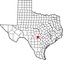 | |
| CDP | ||
| Unincorporated communities | ||
| Ghost towns | ||
| Footnotes | ‡This populated place also has portions in an adjacent county or counties | |