Waverly, West Virginia
For other uses, see Bull Creek (disambiguation).
| Waverly | |
|---|---|
| Census-designated place (CDP) | |
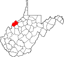
 Waverly Location within the state of West Virginia | |
| Coordinates: 39°20′10″N 81°22′34″W / 39.33611°N 81.37611°WCoordinates: 39°20′10″N 81°22′34″W / 39.33611°N 81.37611°W | |
| Country | United States |
| State | West Virginia |
| County | Wood |
| Area[1] | |
| • Total | 1.482 sq mi (3.84 km2) |
| • Land | 1.482 sq mi (3.84 km2) |
| • Water | 0 sq mi (0 km2) |
| Population (2010)[2] | |
| • Total | 395 |
| • Density | 270/sq mi (100/km2) |
| Time zone | Eastern (EST) (UTC-5) |
| • Summer (DST) | EDT (UTC-4) |
| ZIP codes | 26184 |
Waverly (also known as Bull Creek) is a census-designated place (CDP) in northeastern Wood County, West Virginia, United States. As of the 2010 census, its population was 395.[2] It lies along the Ohio River on West Virginia Route 2, northeast of the city of Parkersburg, the county seat of Wood County.[3] Its elevation is 620 feet (189 m).[4] Although it is unincorporated, it has a post office, with the ZIP code of 26184 and a school.[5]
References
- ↑ "US Gazetteer files: 2010, 2000, and 1990". United States Census Bureau. 2011-02-12. Retrieved 2011-04-23.
- 1 2 "American FactFinder". United States Census Bureau. Retrieved 2011-05-14.
- ↑ Rand McNally. The Road Atlas '08. Chicago: Rand McNally, 2008, p. 112.
- ↑ U.S. Geological Survey Geographic Names Information System: Waverly, West Virginia, Geographic Names Information System, 1980-06-27. Accessed 2008-04-23.
- ↑ Zip Code Lookup
See also
This article is issued from Wikipedia - version of the 5/11/2016. The text is available under the Creative Commons Attribution/Share Alike but additional terms may apply for the media files.