Volcano, California
| Volcano | |
|---|---|
| census-designated place | |
|
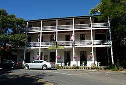
The landmark St. George Hotel in Volcano | |
 Volcano Location in California | |
| Coordinates: 38°26′35″N 120°37′51″W / 38.44306°N 120.63083°WCoordinates: 38°26′35″N 120°37′51″W / 38.44306°N 120.63083°W | |
| Country |
|
| State |
|
| County | Amador County |
| Area[1] | |
| • Total | 1.501 sq mi (3.887 km2) |
| • Land | 1.501 sq mi (3.887 km2) |
| • Water | 0 sq mi (0 km2) 0% |
| Elevation[2] | 2,070 ft (631 m) |
| Population (2010) | |
| • Total | 115 |
| • Density | 77/sq mi (30/km2) |
| ZIP Code | 95689 |
| Area code(s) | 209 |
| GNIS feature ID | 237127,[2] 2583178[3] |
| Website | |
| Reference no. | 29 |
Volcano (formerly, Soldier's Gulch and The Volcano) is a census-designated place[3] in Amador County, California. It lies at an elevation of 2070 feet (631 m). The population was 115 at the 2010 census. It is located at 38°26′35″N 120°37′51″W / 38.44306°N 120.63083°W, just north of Pine Grove. The town is registered as a California Historical Landmark.[4] The community is in ZIP code 95689 and area code 209.
History

The town is named for its setting in a bowl-shaped valley which early miners thought was caused by a volcano.[5] Early morning fog rising from the valley floor only reinforced that belief. The area was first known designated by Colonel Stevenson's men, who mined Soldiers Gulch in 1849. In 1851 a post office was established and by April 1852 there were 300 houses. By 1853 the flats and gulches swarmed with men, and there were 11 stores, six hotels, three bakeries, and three saloons.[6] Hydraulic mining operations, begun in 1855, brought thousands of fortune seekers to form a town of 17 hotels, a library, a theater, and courts of quick justice.[7]
During the Civil War, Volcano's gold served the Union. The Volcano Blues smuggled the cannon "Old Abe," into the town by hearse, to intimidate rebel sympathizers. The cannon was cast by Cyrus Alger & Co. in Boston in 1837 and is the first of two 6-pounders made on the same day to be stamped with serial number 4. This 800 lb cannon held by the Volcano Blues was only fired once during the Civil War. The Confederate faction known as Knights of the Golden Circle owned many of the Main Street business. "Old Abe" was fired down Main Street causing windows to break in all the shops that had not been warned – the ones sympathetic to the South.[8] The other cannon still survives at Shiloh Battlefield and is called "Shiloh Sam". Abe is the only cannon of that age in the U.S. still on a nineteenth century wooden carriage, and has had an interesting history all on its own.
The landmark St. George Hotel is listed on the National Register of Historic Places.
Volcano almost became the county seat in 1854 and again in 1857, but the newspaper closed in 1857 and afterwards, the town began to decline.[9]
Although small, Volcano is a town of many "firsts":[10]
- 1854 First theater group in California
- 1854 First debating society in California
- 1854 First circulating library in California
- 1855 First private schools in California
- 1855 First private law school in California
- 1856 First legal hanging in Amador County
- 1860 First astronomical observatory in California
- 1978 First solar still in California
Tourist attractions
Volcano has a number of Gold Rush-era buildings with signs indicating their historic significance. A post office opened in Volcano in 1851.[11] Volcano boasts one of the longest running general stores in California, having been in continuous use since 1852. The Union Billiard Saloon and Boarding House opened in 1880 and was also the site of the Volcano Justice Court, presided over by Judge Peter Jonas. In 1862, B.F. George built the St. George Hotel on the previous footprint of the Eureka Hotel, which burned down in 1853, and the Empire Hotel, which burned down in 1859. [12] George Madeira established California's first recorded astronomical observatory in 1860 and is where the Great Comet of 1861 was discovered (in the U.S.). It is registered as a California Historical Landmark.[13]
Volcano is also home to Black Chasm Caverns, a National Natural Landmark.
The Volcano Theater Company was founded in 1854. The company conducts a full season each year, performing in both the 35-seat Cobblestone Theater and in the larger outdoor Volcano Amphitheater.
Daffodil Hill is a public garden open each spring to the public at no cost for admission. Daffodils were first planted in the mid-19th century by landowner Pete Denzer to remind him of Holland, his home country. In 1877, Arthur McLaughlin and his wife, “Lizzie” van Vorst-McLaughlin bought the property, which is still owned and managed by their descendants. Approximately 300,000 flowers are in bloom during the Spring. [14]
Notable residents
- James T. Farley, United States Senator for California (1879–1885)[15]
- Harry B. Liversedge, two-time track star at both the 1920 and 1924 Olympics and later Brigadier General best known as the leader of the regiment figured in the historic Iwo Jima flag raising.[16]
- Angelo Joseph Rossi, 31st Mayor of San Francisco, California (1931–1944).[17]
Demographics
The 2010 United States Census[18] reported that Volcano had a population of 115. The population density was 76.6 people per square mile (29.6/km²). The racial makeup of Volcano was 109 (94.8%) White, 0 (0.0%) African American, 2 (1.7%) Native American, 2 (1.7%) Asian, 0 (0.0%) Pacific Islander, 0 (0.0%) from other races, and 2 (1.7%) from two or more races. Hispanic or Latino of any race were 7 persons (6.1%).
The Census reported that 115 people (100% of the population) lived in households, 0 (0%) lived in non-institutionalized group quarters, and 0 (0%) were institutionalized.
There were 55 households, out of which 10 (18.2%) had children under the age of 18 living in them, 23 (41.8%) were opposite-sex married couples living together, 5 (9.1%) had a female householder with no husband present, 5 (9.1%) had a male householder with no wife present. There were 3 (5.5%) unmarried opposite-sex partnerships, and 1 (1.8%) same-sex married couples or partnerships. 18 households (32.7%) were made up of individuals and 4 (7.3%) had someone living alone who was 65 years of age or older. The average household size was 2.09. There were 33 families (60.0% of all households); the average family size was 2.52.
The population was spread out with 20 people (17.4%) under the age of 18, 3 people (2.6%) aged 18 to 24, 11 people (9.6%) aged 25 to 44, 53 people (46.1%) aged 45 to 64, and 28 people (24.3%) who were 65 years of age or older. The median age was 57.1 years. For every 100 females there were 98.3 males. For every 100 females age 18 and over, there were 93.9 males.
There were 70 housing units at an average density of 46.6 per square mile (18.0/km²), of which 37 (67.3%) were owner-occupied, and 18 (32.7%) were occupied by renters. The homeowner vacancy rate was 0%; the rental vacancy rate was 14.3%. 83 people (72.2% of the population) lived in owner-occupied housing units and 32 people (27.8%) lived in rental housing units.
Government
In the California State Legislature, Volcano is in the 8th Senate District, represented by Republican Tom Berryhill,[19] and the 5th Assembly District, represented by Republican Frank Bigelow.[20]
In the United States House of Representatives, Volcano is in California's 4th congressional district, represented by Republican Tom McClintock.[21]
References
- ↑ "2010 Census U.S. Gazetteer Files – Places – California". United States Census Bureau.
- 1 2 "Volcano". Geographic Names Information System. United States Geological Survey. Retrieved 2012-03-30.
- 1 2 "Volcano Census Designated Place". Geographic Names Information System. United States Geological Survey. Retrieved 2012-03-30.
- ↑ "Volcano". Office of Historic Preservation, California State Parks. Retrieved 2012-03-30.
- ↑ "Unincorporated Cities". Amador County Chamber of Commerce. Archived from the original on August 28, 2008. Retrieved 2008-12-01.
- ↑ "Town of Volcano". St. George Hotel. Retrieved 2008-12-01.
- ↑ Koeppel, Elliot H. "Volcano". The California Gold Country: Highway 49 Revisited. Malakoff & Co. ISBN 0-938121-12-X.
- ↑ "Volcano Marker". The Historical Marker Database. Retrieved 2008-12-01.
- ↑ "Volcano". Amador County Archives. Archived from the original on April 9, 2008. Retrieved 2008-12-01.
- ↑ "Volcano Union Inn" (Google cache). BnBstar. Retrieved 2008-12-01.
- ↑ Durham, David L. (1998). California's Geographic Names: A Gazetteer of Historic and Modern Names of the State. Clovis, Calif.: Word Dancer Press. p. 572. ISBN 1-884995-14-4.
- ↑ http://www.stgeorgevolcano.com/index.php/aboutaccessdate=2016-01-28
- ↑ "Memorial To Pioneer Odd Fellowssite of First Amateur Astronomical Observatory of Record In California". Office of Historic Preservation, California State Parks. Retrieved 2012-03-30.
- ↑ http://www.suttercreek.org/sutter-creek-events-daffodil-hill-amador-county.html|accessdate=2016-01-28
- ↑ "History of Volcano". Town of Volcano. Retrieved 2008-12-01.
- ↑ "Harry B. Liversedge, Brigadier General". Arlington National Cemetery. Retrieved 2008-12-01.
- ↑ "San Mateo County". The Political Graveyard. Retrieved 2008-12-01.
- ↑ "2010 Census Interactive Population Search: CA - Volcano CDP". U.S. Census Bureau. Retrieved July 12, 2014.
- ↑ "Senators". State of California. Retrieved March 18, 2013.
- ↑ "Members Assembly". State of California. Retrieved March 18, 2013.
- ↑ "California's 4th Congressional District - Representatives & District Map". Civic Impulse, LLC. Retrieved February 28, 2013.
| Wikimedia Commons has media related to Volcano, California. |
Municipalities and communities of Amador County, California, United States | ||
|---|---|---|
| Cities |  | |
| CDPs | ||
| Unincorporated communities | ||
| Ghost towns |
| |
| Footnotes | ‡This CDP also has portions in an adjacent county or counties | |