Uley Long Barrow
|
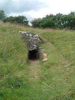
The entrance to Uley Long Barrow | |
 Map showing the location of Uley Long Barrow within Gloucestershire | |
| Details | |
|---|---|
| Established | Prior to 3000 BC |
| Location | Uley, Gloucestershire, England |
| Coordinates | 51°41′55″N 2°18′21″W / 51.6987°N 2.3059°W |
| Owned by | English Heritage |
Uley Long Barrow, also known locally as Hetty Pegler's Tump, is a Neolithic burial mound, near the village of Uley, Gloucestershire, England.
Details
Although typically described as a long barrow, the mound is actually a transepted gallery grave. It was probably built before 3000 BC.[1]

It measures about 37-metre (121 ft) long, 34-metre (112 ft) metres wide, and has a maximum height of 3 metres (9.8 ft).[2] It contains a stone built central passage with two chambers on either side and another at the end. The earthen mound is surrounded by a dry-stone revetting wall.
The barrow was archaeologically excavated in 1821, revealing the remains of 15 skeletons and a later, intrusive Roman age burial above the northeast chamber. It was excavated again in 1854.
The mound is named after Hester, wife of the 17th century landowner Henry Pegler. Hester died in 1694, and Henry in 1695. It is clearly sign-posted from the side of the nearby Crawley Hill (B4066 road) between Uley and Nympsfield. It is about 1.4 kilometres (0.87 mi) to the south of Nympsfield Long Barrow.
The barrow was reopened in 2011 after a short closure for essential health and safety work.
See also
References
- ↑ History and Research: Uley Long Barrow, English Heritage, retrieved 11 April 2012
- ↑ Uley Long Barrow, Pastscape, retrieved 11 April 2012
External links
| Wikimedia Commons has media related to Uley Long Barrow. |
Coordinates: 51°41′55″N 2°18′21″W / 51.69861°N 2.30583°W
