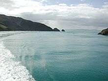
Tory Channel
Tory Channel / Kura Te Au is one of the drowned valleys that form the Marlborough Sounds in New Zealand. Inter-island ferries normally use it as the principal channel between Cook Strait and the Marlborough Sounds.[1][2]
Tory Channel lies to the south of Arapaoa Island, separating it from the mainland. At its western end it joins the larger Queen Charlotte Sound, which it meets halfway along the latter's length. Its eastern end meets Cook Strait close to the strait's narrowest point.[3]
Tory Channel forms a substantial part of the ferry route between Wellington and Picton. Erosion attributed to the ferries, particularly the new faster ones (now discontinued), has resulted in speed restrictions.[4][5]
One of the two candidates for the easternmost point in the South Island (along with Cape Campbell) lies at the entrance of Tory Channel. It is called West Head.
History
Although James Cook anchored several times nearby in Ship Cove, he did not find the channel. Tory Channel was surveyed in 1840 and named after the New Zealand Company ship "Tory", a pioneer ship that brought British colonists to Wellington. Around this time, whaling stations were already operating in Te Awaiti Bay. Between 1911 and 1964, the Perano family hunted whales from Whekenui Bay. Humpback whales were spotted from the hills at the Tory Channel entrance during their migration through Cook Strait. The Perano Whaling Station was the last whaling operation in New Zealand and closed in 1964.
The name of Tory Channel was officially altered to Tory Channel / Kura Te Au in August 2014.[6]
Tidal power
Energy Pacifica has applied for resource consent to install up to ten underwater tidal stream turbine, each able to produce up to 1.2 MW, near the Cook Strait entrance to Tory Channel. They claim Tory Channel has tidal flows of 3.6 metres per second (12 ft/s) with good bathymetry and access to the electricity network.[7]
Notes
- ↑ "The Voyage". Interislander. Retrieved 16 December 2014.
- ↑ "The journey". Buebridge. Retrieved 16 December 2014.
- ↑ "Tory Channel, Marlborough - NZ Topo Map". NZ Topo Map. Land Information New Zealand. Retrieved 16 December 2014.
- ↑ "Ecologically Significant Marine Sites in Marlborough". Marlborough District Council & Department of Conservation. Retrieved 16 December 2014.
- ↑ "Speed limit on Marlborough Sounds upheld". The New Zealand Herald. APN New Zealand Limited. 1 June 2006. Retrieved 16 December 2014.
- ↑ "NZGB decisions". Land Information New Zealand. August 2014. Retrieved 6 November 2015.
- ↑ Benign tides Energy NZ No.6, Spring 2008. Contrafed Publishing.
Coordinates: 41°14′24″S 174°14′00″E / 41.24000°S 174.23333°E
