The Rock, Georgia
| The Rock, Georgia | |
|---|---|
| Unincorporated community | |
 The Rock, Georgia | |
| Coordinates: 32°57′50″N 84°14′28″W / 32.96389°N 84.24111°WCoordinates: 32°57′50″N 84°14′28″W / 32.96389°N 84.24111°W | |
| Country | United States |
| State | Georgia |
| County | Upson |
| Elevation | 823 ft (251 m) |
| Time zone | Eastern (EST) (UTC-5) |
| • Summer (DST) | EDT (UTC-4) |
| ZIP code | 30285 |
| Area code(s) | 706 |
| GNIS feature ID | 333213[1] |
The Rock is an unincorporated community in Upson County, Georgia, United States. The Rock is located on Georgia State Route 36 7 miles (11 km) northeast of Thomaston. The Rock has a post office with ZIP code 30285.,[2] although the post office is on the list to be closed.[3]
References
Municipalities and communities of Upson County, Georgia, United States | ||
|---|---|---|
| City | 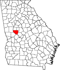 | |
| Town | ||
| CDPs | ||
This article is issued from Wikipedia - version of the 6/24/2016. The text is available under the Creative Commons Attribution/Share Alike but additional terms may apply for the media files.