City Hall Square, Copenhagen
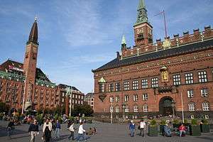
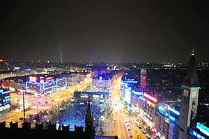
The City Hall Square (Danish: Rådhuspladsen) is a public square in the centre of Copenhagen, Denmark, located in front of the Copenhagen City Hall. Its large size, its central location and its affiliation with the city hall make it a popular venue for a variety of events, celebrations and demonstrations. It is often used as a central point for measuring distances from Copenhagen.
The City Hall Square is located at the southwestern end of the pedestrian street Strøget which connects it to Kongens Nytorv, the other large square of the city centre, passing Gammeltorv/Nytorv and Amagertorv along the way. Opposite Strøget, Vesterbrogade extends into the Vesterbro district and later crosses the border to Frederiksberg. H. C. Andersens Boulevard, Copenhagen's most heavily congested street, and Vester Voldgade pass the square on either side of the city hall.
Apart from the City Hall, notable buildings around the square include Politikens Hus, the headquarters of national daily newspaper Politiken, and Industriens Hus, the headquarters of the DI.
History
Hay market and exhibition area
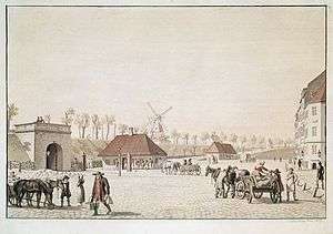
The City Hall Square is located at the site of Copenhagen's old hay market and the Western City Gate with surrounding fortifications.[1]
When the fortifications were disbanded in the 1850s, it was decided to use the vacant land for an exhibition area which played host to first the Nordic Exhibition of 1872 and later the Nordic Exhibition of 1888.[1]
Vilhelm Klein designed an exhibition building for the first exhibition which was built at the corner of Vesterbro Passage which was built from 1870 to 1872. The four-winged, two-storey building was built in red brick to a design which was inspired by Italian Renaissance architecture. In 1879 the centre of the complex was re-built into a large domed exhibition hall.
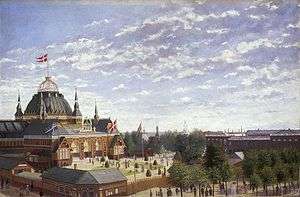
On 1 January 1888 the hay market moved to a new location outside Kødbyen, the new cattle and meat market which had opened in 1878. The site is still named Halmtorvet after it. The main venue of the Nordic Exhibition of 1888 was a large timber structure topped by a huge dome with a flag pole at its top. Its architect was the young and unknown Martin Nyrop who was later also to design the new city hall.
The new city hall and its square
In the 1880s, plans were conceived to build a new city hall on the grounds, and in 1888, the expo area was cleared. An architecture competition was held in early 1889. Apart from Nyrop, who won the competition, Vilhelm Dahlerup and Valdemar Koch were among the participating architects.[1] The design of the city hall was greatly inspired by the Palazzo Pubblico in Siena, Italy, and the design of the square was accordingly modeled on the shell-shaped Piazza del Campo outside that building.[2]
On 28 July 1894, the foundation stone was laid. When it was inaugurated in 1905, the square in front of it became one of the most central and important spaces of the city.
The square was redesigned in 1995 and 1996 by KHR Architects, on the occasion of Copenhagen being the European Capital of Culture. The intersecting street leading from Vesterbrogade to Strøget was removed, uniting the two sides of the square. A bus hub was built on the northern side of the square.[2]
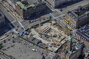
In 2010, work began on a new metro station on the site, requiring a major reorganisation of the site, with work expected to last until 2018.[3]
Sculptures
- The Dragon Fountain (Danish: Dragespringvandet), depicting a bull and a dragon in combat. Designed by Thorvald Bindesbøll and Joakim Skovgaard, out was inaugurated in 1904.
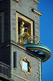
- The Weather Girl (Danish: vejrpigen) is perched high on the Richs building on the corner of Rådhuspladsen and Vesterbrogade, it is a gilded sculpture group telling the weather. One sculpture rotates to the front, depicting the girl with her bicycle. When the weather is set for rain, another sculpture rotates to the front, depicting her with an umbrella walking her dog. The sculpture group is from 1936 and designed by Einar Utzon-Frank.[4]
- The Lur Blowers, a bronze depicting two lur blowers standing atop a column on tiles. Standing 20 m tall, it was created in 1911 to 1913 by Siegfried Wagner.
- A statue of Hans Christian Andersen
Description
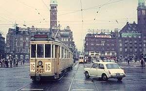
The square's central area is 9800 m².[2] It is often a venue for demonstrations and buskers, and several bars and nightclubs are located in the vicinity. Rådhuspladsen also houses one of the city's bus centrals.
Trivia
- In the Danish edition of the board game Monopoly (Matador), Rådhuspladsen is the most expensive location (see also Localized versions of the Monopoly game).
See also
| Wikimedia Commons has media related to Rådhuspladsen. |
References
- 1 2 3 "Rådhuset og Rådhuspladsen". Selskabet for Københavns Historie. Retrieved 2009-11-08.
- 1 2 3 Gehl, Jan; Gemzøe, Lars (1996). Public Spaces, Public Life, Copenhagen. The Danish Architectural Press and the Royal Danish Academy of Fine Arts. pp. 23, 93. ISBN 877 407 305 2.
- ↑ "Rådhuspladsen". Copenhagen Municipality. Retrieved 8 February 2015.
- ↑ "En særpræget vejrudsigt". DMI. Retrieved 2009-11-08.
External links
Coordinates: 55°40′33″N 12°34′9″E / 55.67583°N 12.56917°E
