Texas State Highway 359
| ||||
|---|---|---|---|---|
 | ||||
| Route information | ||||
| Maintained by TxDOT | ||||
| Length: | 135.233 mi[1] (217.636 km) | |||
| Existed: | 1954 – present | |||
| Major junctions | ||||
| West end: |
| |||
|
| ||||
| East end: |
| |||
| Highway system | ||||
| ||||

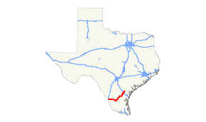
State Highway 359 or SH 359 is a state highway that runs from Skidmore in southeastern Texas, near Corpus Christi, southwest and west to Laredo at the international border with Mexico.
History
The 359 route designation was first used in 1946 for a short stretch of highway in Coleman, but this designation was cancelled and replaced with Texas State Highway Loop 175 in 1947. The current State Highway 359 was designated in 1955 along the old US 59 route from Beeville to Laredo. SH 359 covered essentially its present-day route, plus a co-routing with US 181 from Skidmore to Beeville. In 1960 the dual designation with US 181 from Skidmore to Beeville was removed, which made Skidmore the eastern terminus of SH 359.
Route description
The highway's eastern terminus is the intersection with US 181 at Skidmore. The route runs southwest through Tynan to an intersection with Interstate 37 at Mathis. The route continues in a southwest direction past Lake Corpus Christi through Sandia, Orange Grove and Alfred until it reaches Alice, where it is briefly co-routed with SH 44.
The route then diverges from SH 44 at San Diego and continues southwest through Benavides and Realitos to a junction with SH 16 at Hebbronville. Here the route takes a more western direction and runs through Bruni and Oilton before its final junction with US 83 at Laredo on the Mexican border. Counties traversed by the route include Bee, San Patricio, Jim Wells, Duval, Jim Hogg and Webb. The highway is paved throughout and multi-lane for portions of the route. With the exception of its western terminus at Laredo, most of the terrain covered by the highway is sparsely populated and rural.[2]
Major intersections
| County | Location | mi | km | Destinations | Notes | |||
|---|---|---|---|---|---|---|---|---|
| Webb | Laredo | Houston Street (I-35 Bus. south) / Santa Ursula Avenue - International Bridge No. 1, International Bridge No. 2 | ||||||
| Interchange; east end of US 83 overlap | ||||||||
| Interchange | ||||||||
| | ||||||||
| | ||||||||
| Bruni | ||||||||
| Duval |
No major junctions | |||||||
| Jim Hogg | Hebbronville | West end of SH 16 overlap | ||||||
| East end of SH 16 overlap | ||||||||
| Duval | Realitos | |||||||
| Benavides | West end of FM 2295 overlap | |||||||
| West end of SH 339 overlap | ||||||||
| East end of SH 339 overlap | ||||||||
| East end of FM 2295 overlap | ||||||||
| San Diego | ||||||||
| West end of SH 44 overlap | ||||||||
| see SH 44 | ||||||||
| Jim Wells | | Interchange; east end of SH 44 overlap | ||||||
| | ||||||||
| | ||||||||
| | ||||||||
| Orange Grove | ||||||||
| Casa Blanca | ||||||||
| Sandia | ||||||||
| San Patricio | | |||||||
| Mathis | ||||||||
| I-37 exit 36 | ||||||||
| Bee | Tynan | West end of FM 796 overlap | ||||||
| East end of FM 796 overlap | ||||||||
| Skidmore | ||||||||
| 1.000 mi = 1.609 km; 1.000 km = 0.621 mi | ||||||||
References
- ↑ Transportation Planning and Programming Division (n.d.). "State Highway No. 359". Highway Designation Files. Texas Department of Transportation. Retrieved 2006-12-23.
- ↑ Google (2008-03-08). "overview map of SH 359" (Map). Google Maps. Google. Retrieved 2008-03-08.
External links
- State Highway 359 at aaroads.com/texas
- Texas official travel map at the Texas Department of Transportation (Adobe Acrobat format, magnification required for legibility)
