Taylor, Cotton County, Oklahoma
| Taylor | |
|---|---|
| Unincorporated community | |
 Taylor  Taylor Location within the state of Oklahoma | |
| Coordinates: 34°10′25″N 98°19′52″W / 34.17361°N 98.33111°WCoordinates: 34°10′25″N 98°19′52″W / 34.17361°N 98.33111°W | |
| Country | United States |
| State | Oklahoma |
| County | Cotton |
| Time zone | Central (CST) (UTC-6) |
| • Summer (DST) | CDT (UTC-5) |
| GNIS feature ID | 1100877 |
- For the community in Beckham County, Oklahoma, see Taylor, Beckham County, Oklahoma.
Taylor is an unincorporated community in Cotton County, Oklahoma.[1] The elevation is 994 feet.[1] It was named after a local merchant, John Taylor.[2] The community had a post office from November 30, 1907 to May 31, 1911.[2]
References
- 1 2 U.S. Geological Survey Geographic Names Information System: Taylor, Cotton County, Oklahoma
- 1 2 Shirk, George H. Oklahoma Place Names, Norman, Oklahoma: University of Oklahoma Press, 1965, p.203.
Municipalities and communities of Cotton County, Oklahoma, United States | ||
|---|---|---|
| City | 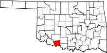 | |
| Towns | ||
| Unincorporated communities | ||
This article is issued from Wikipedia - version of the 7/31/2016. The text is available under the Creative Commons Attribution/Share Alike but additional terms may apply for the media files.