Tadpole Bridge
| Tadpole Bridge | |
|---|---|
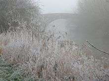 Tadpole bridge in December mist | |
| Coordinates | 51°42′08″N 1°31′00″W / 51.702248°N 1.516643°WCoordinates: 51°42′08″N 1°31′00″W / 51.702248°N 1.516643°W |
| Carries | unnumbered road |
| Crosses | River Thames |
| Locale | Bampton, Oxfordshire |
| Maintained by | Oxfordshire County Council |
| Characteristics | |
| Design | arch |
| Material | stone |
| Height | 14 feet 10 inches (4.52 m) |
| Number of spans | 1 |
| Load limit | 18 tonnes (18 long tons; 20 short tons) |
| History | |
| Opened | late 18th century |
Tadpole Bridge is a road bridge across the River Thames in Oxfordshire, England, carrying a road between Bampton to the north and Buckland to the south. It crosses the Thames on the reach above Shifford Lock.
The bridge dates from the late 18th century, the earliest reference to it being in 1784. It is built of stone, and consists of one large arch.[1]
There is a public house near Tadpole Bridge called The Trout. Thacker noted that at one time the legend over the door read "The Trout, kept by A. Herring".[1] The Trout is now a hotel and gastropub.[2]
The Thames Path crosses Tadpole Bridge.
See also
References
- 1 2 Thacker, Fred. S. (1968) [1920]. The Thames Highway: Volume II Locks and Weirs. Newton Abbot: David and Charles. p. not cited.
- ↑ The Trout at Tadpole Bridge
| Next crossing upstream | River Thames | Next crossing downstream |
| Rushey Lock (pedestrian) | Tadpole Bridge | Tenfoot Bridge (pedestrian) |
| Next crossing upstream | Thames Path | Next crossing downstream |
| southern bank Radcot Bridge |
Tadpole Bridge | northern bank Tenfoot Bridge |
This article is issued from Wikipedia - version of the 10/3/2015. The text is available under the Creative Commons Attribution/Share Alike but additional terms may apply for the media files.
