Tömörkény
| Tömörkény | |
|---|---|
| Country |
|
| County | Csongrád |
| Area | |
| • Total | 53.91 km2 (20.81 sq mi) |
| Population (2015) | |
| • Total | 1,712[1] |
| • Density | 37/km2 (100/sq mi) |
| Time zone | CET (UTC+1) |
| • Summer (DST) | CEST (UTC+2) |
| Postal code | 6646 |
| Area code(s) | 63 |
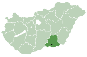
Location of Csongrád County in Hungary
Tömörkény is a village near the town of Csongrád in Csongrád county, in the Southern Great Plain region of southern Hungary.
Geography
It covers an area of 53.91 km2 (21 sq mi) and in 2015 had a population of 1,712.[1]
History
The first settlement was built by the Sarmatas and the Avars. There was some cemetery and iron working equipment found. It first legal sign from the 11th century, named "Temerken". In Turkish times, a small fortress defended the local people. The old village was a harbor to move through the Tisza River. Nowadays, it is a typical agricultural village.
References
- 1 2 Gazetteer of Hungary, 1st January 2015. Hungarian Central Statistical Office. 03/09/2015
County seat: Szeged | ||
| Cities and towns | 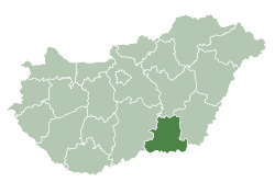 | |
| Villages |
| |
| Other topics |
| |
Coordinates: 46°37′N 20°02′E / 46.617°N 20.033°E
This article is issued from Wikipedia - version of the 5/16/2016. The text is available under the Creative Commons Attribution/Share Alike but additional terms may apply for the media files.