Stolbovoy Island
| Stolbovoy Столбовой остров | |
|---|---|
| Island | |
|
Map of Stolbovoy Island. | |
 Location of Stolbovoy Island | |
 Stolbovoy Location of Stolbovoy Island | |
| Coordinates: RU 74°04′15″N 135°59′30″E / 74.07083°N 135.99167°E | |
| Country | Russian Federation |
| Federal subject | Far Eastern Federal District |
| Republic | Sakha Republic |
| Area | |
| • Total | 170 km2 (70 sq mi) |
| Elevation | 222 m (728 ft) |
| Population | |
| • Total | uninhabited |

Stolbovoy Island (Russian: Столбовой остров) is a long and narrow island off the southwest side of the New Siberian archipelago in the eastern part of the Laptev Sea. It is located 184 km away from the Siberian coast and 100 km southwest of Kotelny Island, being thus quite detached from the New Siberian island group, although it belongs to the Lyakhov Islands subgroup of the New Siberian Islands.
Geography and climate
Stolbovoy Island's area is approximately 170 km². Its length is 47 km and its maximum width is 10 km. There is a 5 km long lake in the northeast of the island. It is separated from the sea by a narrow spit. The highest point of Stolbovoy Island is 222 meters. The island has 15–70 m high rocky cliffs, the lower relief down to the beach being dominated by step-like stony structures. It belongs to the Sakha Republic administrative division of the Russian Federation.
The climate in the area is exceptionally severe, with prolonged, bitter winters, so that the waters of the Laptev Sea around Stolbovoy Island are covered by ice most of the year.
Geology
Tectonically deformed sedimentary rocks that accumulated during Late Jurassic to Early Cretaceous periods comprise Stolbovoy Island. These turbidites, which contain the fossils of marine pelecypods, consist of beds of sandstone coarsely and rhythmically interbedded with beds of siltstone and argillite. These rocks have been folded into a synclinal structure, thrust faulted, and intruded by small quartz diorite dikes.[1][2]
Vegetation
Cryptogam herb covers practically barren Stolbovoy Island. All vegetation consists of dry to wet barren landscapes with scattered, herbs, lichens, mosses, and liverworts. Sedges, dwarf shrubs, and peaty mires are normally absent. These plants form a sparse (2-40%) and low-growing plant cover. The plants often grow in coarse-grained, often calcareous sediments[3]
Views
 Part of the coast of Stolbovoy showing the cliff formations. |
 The odd stony structures in the cliffs on Stolbovoy. |
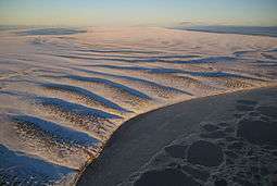 The undulated and desolate terrain of Stolbovoy. |
See also
References
- ↑ Kos’ko, M.K., B.G. Lopatin, and V.G. Ganelin, 1990, Major geological features of the islands of the East Siberian and Chukchi Seas and the Northern Coast of Chukotka. Marine Geology. vol. 93, pp. 349–367.
- ↑ Fujita, K., and D.B. Cook, 1990, The Arctic continental margin of eastern Siberia, in A. Grantz, L. Johnson, and J. F. Sweeney, eds., pp. 289-304, The Arctic Ocean Region. Geology of North America, vol L, Geological Society of America, Boulder, Colorado.
- ↑
- CAVM Team, 2003, Circumpolar Arctic Vegetation Map. Scale 1:7,500,000. Conservation of Arctic Flora and Fauna (CAFF) Map No. 1. U.S. Fish and Wildlife Service, Anchorage, Alaska.
External links
- anonymous, nd, Laptev Sea Alfred Wegener Institute for Polar and Marine Research - Research Unit Potsdam, Potsdam, Germany.
- BirdLife International, 2008, RU118 Stolbovoy island. BirdLife's online World Bird Database: the site for bird conservation. Version 2.1. Cambridge, UK: BirdLife International.
- Grigoriev, M., nda, ice-affected pebble beach of Stolbovoy Island Alfred Wegener Institute for Polar and Marine Research - Research Unit Potsdam, Potsdam, Germany
- Grigoriev, M., ndb, rocky cliffs (15-70 m high) of Stolbovoy Island Alfred Wegener Institute for Polar and Marine Research - Research Unit Potsdam, Potsdam, Germany
