Stewart Mountain Dam
| Stewart Mountain Dam | |
|---|---|
 Stewart Mountain Dam | |
| Country | United States of America |
| Location | Maricopa County, Arizona |
| Coordinates | 33°34′00″N 111°32′08″W / 33.56667°N 111.53556°WCoordinates: 33°34′00″N 111°32′08″W / 33.56667°N 111.53556°W |
| Status | Operational |
| Construction began | 1928 |
| Opening date | 1930 |
| Owner(s) | United States Bureau of Reclamation |
| Dam and spillways | |
| Type of dam | Arch dam |
| Impounds | Salt River |
| Height | 207 feet (63 m)[1] |
| Length | 1,260 feet (380 m)[1] |
| Elevation at crest | 1,533 feet (467 m)[1] |
| Width (crest) | 8 feet (2.4 m)[1] |
| Width (base) | 33 feet (10 m)[1] |
| Dam volume | 120,000 cubic yards (92,000 m3)[1] |
| Reservoir | |
| Total capacity | 73,613 acre feet (90,800,000 m3)[1] |
| Catchment area | 6,330 square miles (16,400 km2)[1] |
| Surface area | 1,260 acres (510 ha)[2] |
| Power station | |
| Operator(s) | Salt River Project |
| Type | Conventional |
| Hydraulic head | 116 feet (35 m)[1] |
| Installed capacity | 13 MW |
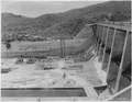
The Stewart Mountain Dam is a concrete thin arch dam located 41 miles northeast of Phoenix, Arizona. The dam is 1,260 feet (380 m) long, 207 feet (63 m) high, and was built between 1928-30. The dam includes a 13,000 kilowatt (kW) hydroelectric generating unit that is operated by SRP (Salt River Project), an Arizona public utility. It is primarily operated during the summer months. The dam forms Saguaro Lake as it slows the passage of the Salt River in Maricopa County, Arizona. It was named after a ranch that used to be located nearby known as the Old Stewart Ranch.
Construction
 25 June 1936

References
External links
- Historic American Engineering Record (HAER) No. AZ-12, "Stewart Mountain Dam, Spanning the Salt River, Tempe, Maricopa County, AZ", 65 photos, 61 data pages, 5 photo caption pages
This article is issued from Wikipedia - version of the 9/26/2015. The text is available under the Creative Commons Attribution/Share Alike but additional terms may apply for the media files.
