St Anton am Arlberg
| Sankt Anton am Arlberg | ||
|---|---|---|
|
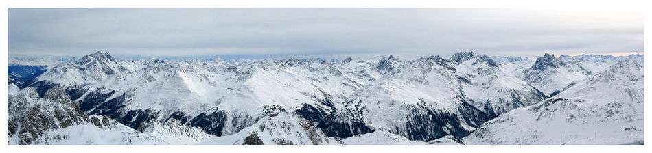
Sankt Anton am Arlberg in February 2016 | ||
| ||
 Sankt Anton am Arlberg Location within Austria | ||
| Coordinates: 47°07′N 10°16′E / 47.117°N 10.267°ECoordinates: 47°07′N 10°16′E / 47.117°N 10.267°E | ||
| Country | Austria | |
| State | Tyrol | |
| District | Landeck | |
| Government | ||
| • Mayor | Helmut Mall (ÖVP) | |
| Area | ||
| • Total | 165.81 km2 (64.02 sq mi) | |
| Elevation | 1,304 m (4,278 ft) | |
| Population (1 January 2016)[1] | ||
| • Total | 2,349 | |
| • Density | 14/km2 (37/sq mi) | |
| Time zone | CET (UTC+1) | |
| • Summer (DST) | CEST (UTC+2) | |
| Postal code | 6580 | |
| Area code | 05446 | |
| Vehicle registration | LA | |
| Website | www.stantonamarlberg.com | |


Sankt Anton am Arlberg, commonly referred to as St. Anton, is a village and ski resort in the Austrian state of Tyrol. It lies in the Tyrolean Alps, with aerial tramways and chairlifts up to 2,811 m (9,222 ft), yielding a vertical drop of 1,507 m (4,944 ft). It is also a popular summer resort among hikers, trekkers and mountaineers.
Skiing has a long history in St. Anton: ski instructors from the area emigrated to the US in the 1930s, helping to popularise the sport. St. Anton was the host of the Alpine World Ski Championships in 2001. St. Anton is frequently listed as one of the world's top skiing resorts both in terms of skiing available and après-ski entertainment.[2]
Geography
St. Anton lies on the Rosanna River and is on the main east-west rail line between Austria and Switzerland. There are many airports that serve St. Anton by way of train and car that include Munich, Zürich, Innsbruck and Friedrichshafen. The centre is a pedestrian zone.
Activities
Skiing
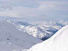
St. Anton is part of the Arlberg area of ski resorts – a region that includes 94 cable cars and ski lifts, 340 km (210 mi) of groomed pistes and 200 km (120 mi) of deep-snow runs, all of which are covered under one liftpass.
On the western edge of village is the "Galzigbahn" which has been replaced by a Funitel gondola. The new gondola includes a first-ever "Ferris wheel": enabling passengers to board the gondolas on ground level, then rotating the gondolas up to the main high-speed cables. The Funitel accesses the Galzig slopes and connects to Schindler and Valluga peaks. On the eastern edge of town, the Nassereinbahn rises to the Nasserein area with connections to the Kapall peak. The Kapall, Valluga, and Schindler peaks provide skiers with close to 1,500 vertical metres skiing (4,920 ft). Slope-side après-ski bars can be found on the Steissbachtal trail just above St. Anton.
The groomed runs in the region cater to all levels; 43% are for beginners (blue), 41% for intermediate skiers (red) and 16% are for the more advanced (black). There are also 200 km (120 mi) of deep snow runs in the area.
Expert terrain includes less-frequently groomed ski routes such as Schindlerkar and Mattun, and the backside of Valluga (2,811 metres or 9,222 feet) down to Zürs, which is for experts only if accompanied by a guide. There are also a large number of off-piste routes in the area that experts can explore with the help of a guide.
Other ski areas are St. Christoph, a hamlet where in the 14th century the shepherd Heinrich Findelkind built a hospice as a shelter for travellers crossing the Arlberg pass to the Vorarlberg province, Stuben, Lech, Zürs, Warth-Schröcken and Klösterle/Sonnenkopf.
Transportation
By car, St. Anton is easily reached, making use of the A14 motorway, which runs from Vorarlberg (Austria's westernmost state, which borders Lichtenstein and Switzerland) and then follows the spine of the Tyrol. Alternatively, St. Anton, Langen am Arlberg and Kloesterle (all located in the Arlberg ski region) have railway stations. Both St. Anton and Langen am Arlberg are stops on international train services between Zuerich and Budapest, making it easy to reach the ski area from across the continent.
St. Anton and surrounding villages/resorts are served by a network of bus routes. In the town itself, there are two hubs; known as the "Terminal Ost" and the "Terminal West". "Terminal Ost" gives access to the Nassereinbahn Gondola and the "Terminal West" to the Galzigbahn/ Rendlbahn gondolas as well as the town's railway station. There is a route with frequent, year-round services between St. Anton and Landeck, the latter being a town located at the entrance to the main valley (Stanzertal, as it is known in the local area). Frequent free bus services also operate between different parts of St. Anton town as well as from Pettneu, Schnann and Flirsch.
Further information regarding bus and train travel can be found by viewing the St. Anton website.
Other activities
There are other activities one can do in St. Anton. There are many sightseeing spots around the village, cycle tracks and a sports centre with pools, whirlpools and a water slide.
During the summer months, many tourists come to hike the mountain and one can even go cross-country on a Segway PT.
In popular culture
The resort was featured extensively in the 2011 film Chalet Girl, a romantic comedy starring Felicity Jones, Ed Westwick and Bill Nighy. The resort of Garmisch-Partenkirchen in Germany was also used for some interior shots.
St. Anton was shown in the 1969 film Downhill Racer, starring Robert Redford and Gene Hackman.
St. Anton was also the setting for the film "Der Weisse Rausch", starring Leni Riefenstahl and local ski instructor Hannes Schneider. Made in 1931, the comedy film was a fictional account of the skiing exploits of a young village girl, played by Riefenstahl, and her attempts to master the sport of skiing and ski-jumping aided by the local ski expert Hannes Schneider. The film was one of the first to use and develop outdoor film-making techniques and featured several innovative action-skiing scenes. Riefenstahl went on to make nazi propaganda films and, post-war, subsequently lived in Africa where she continued film-making, but now of life in the African bush. She survived two fatal crashes, a helicopter and a road accident, in the process. Hannes Schneider, post-war, became the world-famous ski instructor of the downhill skiing method known as the "Arlberg technique".
Statistics
- Elevation: village: 1,304 m (4,278 ft); top: 2,811 m (9,222 ft).
- Vertical: 1,507 m (4,944 ft).
- Longest run: 10.2 km (6.3 mi), Valluga to St. Anton.
- Lifts: 94 (Ski*Arlberg); 11 gondolas; 51 chairlifts (one 10-passenger, one 8-passenger, fifteen 6-passenger, 15 quads, 1 triples, 18 doubles); 32 T-bars lifts.
- Lift capacity: 151,010 per hour.[3]
- Ski season: early December to late April.
- Cross country: 41 km (25 mi) total: Stanzertal 22 km (14 mi), Verwall 10 km (6 mi), St Christoph 2.5 km (2 mi), Ganderau 3 km (1.9 mi), Reit 2 km (1.2 mi), Pofel 15 km (9.3 mi)
- Mountain restaurants: 18.
- Après-ski: ski museum; 15 cafés, 8 ice bars, 3 discos, 7 bars.
- Lodging: 8,900 beds; hotels, gasthof, apartments, private pensions in St. Anton, St Jakob and St Christoph.
References
- ↑ Statistik Austria - Bevölkerung zu Jahresbeginn 2002-2016 nach Gemeinden (Gebietsstand 2016-01-01), 2016-01-01.
- ↑ "St Anton". Alpine Marketing. Retrieved 2016-04-28.
- ↑ "Sankt Anton Winter", www.stantonamarlberg.com, 2011 ; Web page: www.stantonamarlberg.com/winter/ViewPage.asp?Site=STANTON2-WINTER&PageID=206&lang=201.
- Sources
- Chris Gill and Dave Watts, Where to Ski and Snowboard 2007, ISBN 0-9536371-8-2.
- John Darrell Sherwood, "Going Further Afield: St. Anton, Austria", 23 February 2003
- Ski-Europe article on St. Anton.
- Jacqueline McGibbon, The Business of Alpine Tourism in a Globalising World – an anthropological study of international tourism in the village of St. Anton am Arlberg in the Tirolean Alps.
External links
| Wikimedia Commons has media related to Sankt Anton am Arlberg. |
- Official website
- Arlberger Bergbahnen AG (cable car company)
- Weather, webcams, videos, etc. from Sankt Anton am Arlberg
