Spring City, Utah
| Spring City, Utah | |
|---|---|
| City | |
|
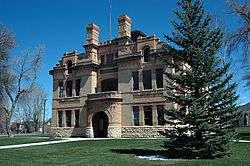
Old Spring City schoolhouse | |
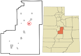 Location in Sanpete County and the state of Utah. | |
| Coordinates: 39°28′49″N 111°29′29″W / 39.48028°N 111.49139°WCoordinates: 39°28′49″N 111°29′29″W / 39.48028°N 111.49139°W | |
| Country | United States |
| State | Utah |
| County | Sanpete |
| Settled | 1852 |
| Named for | Springs |
| Area | |
| • Total | 1.3 sq mi (3.4 km2) |
| • Land | 1.3 sq mi (3.4 km2) |
| • Water | 0.0 sq mi (0.0 km2) |
| Elevation | 5,823 ft (1,775 m) |
| Population (2012) | |
| • Total | 994 |
| • Density | 720.5/sq mi (278.2/km2) |
| Time zone | Mountain (MST) (UTC-7) |
| • Summer (DST) | MDT (UTC-6) |
| ZIP code | 84662 |
| Area code(s) | 435 |
| FIPS code | 49-71730[1] |
| GNIS feature ID | 1445992[2] |
Spring City is a city in Sanpete County, Utah, United States. The population was 956 at the 2000 census. Although it is still largely a farming town, Spring City is becoming increasingly known as an artist community.[3] Many excellent examples of Mormon pioneer architecture exist throughout the town. In 2010, Forbes magazine identified Spring City as one of the prettiest towns in America.
Orson Hyde, an early apostle of The Church of Jesus Christ of Latter-day Saints, is buried in the Spring City Cemetery.
Geography
According to the United States Census Bureau, the city has a total area of 1.3 square miles (3.5 km²), all of it land.
History
Spring City was first known as "Allred Settlement".[4] The original settlers in 1852 were under the leadership of James Allred and most of them were his family members. When an LDS ward was organized there in 1853, Ruben W. Allred was appointed the first bishop. The settlement was abandoned in the summer of 1853 because of ongoing conflict with the indigenous people of the area,[5] the Ute people, including San Pitch Utes, from which Sanpete county derives its name.[6][7] The village was reestablished as "Springtown" in 1859 by William Black, George Black and Joseph S. Black. Christen G. Larsen was made bishop of a new LDS ward in 1860.
Beginning in 1853, the Allred family and other church leaders began to encourage Danish immigrants to settle in Sanpete County, and, particularly after the community was reestablished in 1859, to join the Allred Settlement.
By the mid-1860s locals referred to the north side of town as "Little Copenhagen" or "Little Denmark".[5]
Spring City was also a site of fighting during the Black Hawk War.[8]
Its mayor, Jack Monnett, is the nation's only Constitution Party mayor at present.[9]
Demographics
| Historical population | |||
|---|---|---|---|
| Census | Pop. | %± | |
| 1860 | 243 | — | |
| 1870 | 623 | 156.4% | |
| 1880 | 989 | 58.7% | |
| 1890 | 1,044 | 5.6% | |
| 1900 | 1,135 | 8.7% | |
| 1910 | 1,100 | −3.1% | |
| 1920 | 1,106 | 0.5% | |
| 1930 | 902 | −18.4% | |
| 1940 | 839 | −7.0% | |
| 1950 | 703 | −16.2% | |
| 1960 | 463 | −34.1% | |
| 1970 | 456 | −1.5% | |
| 1980 | 671 | 47.1% | |
| 1990 | 715 | 6.6% | |
| 2000 | 956 | 33.7% | |
| 2010 | 988 | 3.3% | |
| Est. 2015 | 1,002 | [10] | 1.4% |
The 2000 census[1] recorded 956 people, 312 households, and 243 families residing in the city. The population density was 720.5 people per square mile (277.5/km²). There were 370 housing units at an average density of 278.8 per square mile (107.4/km²). The racial makeup of the city was 94.98% White, 0.10% African American, 0.31% Native American, 0.21% Asian, 0.42% Pacific Islander, 1.88% from other races, and 2.09% from two or more races. Hispanic or Latino of any race were 3.56% of the population.
There were 312 households out of which 41.7% had children under the age of 18 living with them, 70.2% were married couples living together, 6.4% had a female householder with no husband present, and 22.1% were non-families. 17.6% of all households were made up of individuals and 8.3% had someone living alone who was 65 years of age or older. The average household size was 3.06 and the average family size was 3.53.
In the city the population was spread out with 33.6% under the age of 18, 11.1% from 18 to 24, 23.8% from 25 to 44, 21.8% from 45 to 64, and 9.7% who were 65 years of age or older. The median age was 30 years. For every 100 females there were 96.3 males. For every 100 females age 18 and over, there were 99.7 males.
The median income for a household in the city was $34,609, and the median income for a family was $37,813. Males had a median income of $36,500 versus $20,417 for females. The per capita income for the city was $12,310. About 15.6% of families and 20.2% of the population were below the poverty line, including 25.3% of those under age 18 and 17.7% of those age 65 or over.
Education
Spring City is located in the North Sanpete School District and contains an elementary school. Students attend middle school at North Sanpete Middle School in Moroni and high school at North Sanpete High School in Mount Pleasant.
Spring City Historic District
|
Spring City Historic District | |
  | |
| Location | UT 17, Spring City, Utah |
|---|---|
| Area | 37 acres (15 ha) |
| Built | 1851 |
| Architectural style | Mormon vernacular |
| NRHP Reference # | 80003957[12] |
| Added to NRHP | October 22, 1980 |
The Spring City Historic District boundaries coincide with the city limits. This historical designation recognizes Spring City's status as a well-preserved example of a Mormon settlement. The district is primarily residential in character, but includes the town's commercial core.[13]
Spring City was listed on the National Register of Historic Places on October 22, 1980.[12]
Notable residents
- Orson Hyde, Mormon apostle
- Jacob Johnson, U.S. Representative from Utah
- F. Michael Watson, Mormon general authority
References
- 1 2 "American FactFinder". United States Census Bureau. Retrieved 2008-01-31.
- ↑ "US Board on Geographic Names". United States Geological Survey. 2007-10-25. Retrieved 2008-01-31.
- ↑ "Welcome to Spring City Arts". Spring City Arts, a 501(c)(3) non-profit organization dedicated to promoting art, artists, art awareness and art education in Spring City, Sanpete County and Utah. Spring City Arts. Retrieved 21 March 2014.
- ↑ Spring City web page
- 1 2 "HISTORY". The Founding of Spring City. Friends of Historic Spring City. Retrieved 21 March 2014.
- ↑ "Sanpete County". I Love History. Utah Division of State History (Utah state government agency). Retrieved 21 March 2014.
- ↑ Fletcher, Lyle. "Where did Sanpete Get It's Name?". The Black Hawk War: Utah's Forgotten Tragedy (website) and the San Pete Messenger (newspaper). San Pete Messenger. Retrieved 21 March 2014.
- ↑ Andrew Jenson, Encyclopedic History of The Church of Jesus Christ of Latter-day Saints, p. 827
- ↑ The Constitution Party page on elected office holders
- ↑ "Annual Estimates of the Resident Population for Incorporated Places: April 1, 2010 to July 1, 2015". Retrieved July 2, 2016.
- ↑ "Census of Population and Housing". Census.gov. Retrieved June 4, 2015.
- 1 2 National Park Service (2010-07-09). "National Register Information System". National Register of Historic Places. National Park Service.
- ↑ Carter, Tom (January 1979). "National Register of Historic Places Inventory - Nomination Form: Spring City Historic District" (PDF). National Park Service. Retrieved 4 March 2014.
External links
| Wikimedia Commons has media related to Spring City, Utah. |
- Official website
- Historic American Buildings Survey (HABS) No. UT-70, "Spring City Area Study, Spring City, Sanpete County, UT", 5 photos, 1 measured drawing, 3 data pages
- HABS No. UT-70-A, "Spring City Area Study, Adobe House, First Street, Spring City, Sanpete County, UT", 1 photo
- HABS No. UT-70-B, "Spring City Area Study, Bishop's Storehouse, Fourth & E Streets, Spring City, Sanpete County, UT", 2 photos
- HABS No. UT-70-C, "Spring City Area Study, City Hall, Main Street, Spring City, Sanpete County, UT", 2 photos
- HABS No. UT-70-D, "Spring City Area Study, Frame House, Second & B Streets, Spring City, Sanpete County, UT", 2 photos
- HABS No. UT-70-E, "Spring City Area Study, Peter Hons House, Fourth & F Streets, Spring City, Sanpete County, UT", 1 photo
- HABS No. UT-70-F, "Spring City Area Study, Orson Hyde House, Main & C Streets, Spring City, Sanpete County, UT", 2 photos
- HABS No. UT-70-G, "Spring City Area Study, Log Cabin, First & B Streets, Spring City, Sanpete County, UT", 1 photo
- HABS No. UT-70-H, "Spring City Area Study, Log Cabin, Spring City, Sanpete County, UT", 2 photos
- HABS No. UT-70-I, "Spring City Area Study, Masonic Lodge, B Street, Spring City, Sanpete County, UT", 2 photos
- HABS No. UT-70-J, "Spring City Area Study, Public School, Fourth & E Streets, Spring City, Sanpete County, UT", 2 photos
- HABS No. UT-70-K, "Spring City Area Study, Stone House, Main & F Streets, Spring City, Sanpete County, UT", 1 photo
- HABS No. UT-70-L, "Spring City Area Study, Tithing Barn, Second Street, Spring City, Sanpete County, UT", 1 photo
- HABS No. UT-70-M, "Spring City Area Study, Tithing Office, Second Street, Spring City, Sanpete County, UT", 2 photos
- HABS No. UT-70-<, "Spring City Area Study, Ward Chapel, Main Street, Spring City, Sanpete County, UT", 5 photos
 |
Moroni | Mount Pleasant | Price | |
| Wales | |
Wellington Huntington | ||
| ||||
| | ||||
| Fayette | Ephraim | Manti-La Sal National Forest / Orangeville, Castle Dale Clawson Ferron |
Municipalities and communities of Sanpete County, Utah, United States | ||
|---|---|---|
| Cities | 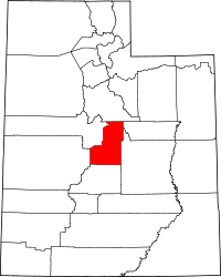 | |
| Towns | ||
| Unincorporated communities | ||
| Ghost towns | ||