Sharp Mountain
Sharp Mountain or Sharp Ridge (historically also spelled 'Sharpe') in eastern central Pennsylvania in the United States is a ridgeline (fold) of the Ridge-and-Valley Appalachians cut through on its east-side in the Tamaqua gap by the Little Schuylkill River which sunders it from the eastern extension of the ridgeline, the Nesquehoning Ridge. The ridgeline, located in the heart of the Pennsylvania Anthracite Coal Region, drains to the Susquehanna along its western slopes and via the Little Schuylkill tributary of the Schuylkill River on its eastern faces.
 |
 |
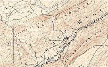
| Sharp Mountain extending south and west from Tamaqua gap and the double-confluence of the Schuylkill River and the Little Schuylkill Rivers with Panther Creek. | |
The heavily forested, relatively steep slopes of Sharp and Nesquehoning Mountains characterize the landscapes within the Anthracite Upland. Sharp Mountain is reported as the first locale where the coal of the region was discovered by a man hunting in 1788. When another hunter found and reported anthracite 5−6 miles to the east of Tamaqua, in what became Summit Hill, Pennsylvania, the Lehigh Coal Mining Company was formed in 1792 and began exploiting these finds.
Large areas in the valleys to either side have been disturbed by coal mining related activities. Much of the runoff from strip mines is retained in abandoned pits and therefore lesser amounts of surface runoff is discharged into the local creeks.
See also
- List of rivers of Pennsylvania
- Broad Mountain
- Mauch Chunk Mountain
- Nesquehoning Mountain
- Pisgah Mountain
External links
References
Coordinates: 40°51′43″N 75°50′23″W / 40.86182°N 75.83966°W