Sgeotasaigh
| Gaelic name | Sgeotasaig |
|---|---|
| Location | |
 Sgeotasaigh Scotasay shown within the Outer Hebrides | |
| OS grid reference | NG185975 |
| Physical geography | |
| Island group | Lewis and Harris |
| Area | 49 ha |
| Area rank | 205= [1] |
| Highest elevation | 57 m |
| Administration | |
| Sovereign state | United Kingdom |
| Country | Scotland |
| Council area | Na h-Eileanan Siar |
| Demographics | |
| Population | 0 |
| References | [2][3][4] |
Scotasay (Scottish Gaelic: Sgeotasaigh) is an uninhabited island in the Outer Hebrides of Scotland. It lies 1 kilometre (0.6 miles) off the east coast of Harris and gives some shelter to the ferry port of Tarbert.
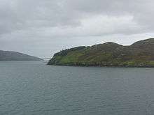
Sgeotasaigh from the Tarbert ferry.
References
- ↑ Area and population ranks: there are c. 300 islands over 20 ha in extent and 93 permanently inhabited islands were listed in the 2011 census.
- ↑ National Records of Scotland (15 August 2013) (pdf) Statistical Bulletin: 2011 Census: First Results on Population and Household Estimates for Scotland - Release 1C (Part Two). "Appendix 2: Population and households on Scotland’s inhabited islands". Retrieved 17 August 2013.
- ↑ Haswell-Smith, Hamish (2004). The Scottish Islands. Edinburgh: Canongate. ISBN 978-1-84195-454-7.
- ↑ Ordnance Survey. Get-a-map (Map). 1:25,000. Leisure. Ordinance Survey. Retrieved 21 August 2013.
| Inhabited islands | ||
|---|---|---|
| Other islands | ||
| Settlements |
| |
| Districts | ||
| Geographical features | ||
| Historical sites | ||
Coordinates: 57°52′40″N 6°45′00″W / 57.87790°N 6.75013°W
This article is issued from Wikipedia - version of the 7/18/2016. The text is available under the Creative Commons Attribution/Share Alike but additional terms may apply for the media files.