Seaforth Island
- There is also a Seaforth Island in the Whitsunday Islands of Queensland, Australia
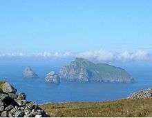
Seaforth Island (Scottish Gaelic: Eilean Shìphoirt/Shìophoirt or Mulag) is an uninhabited island in the Outer Hebrides of Scotland. Unlike many other islands of the Outer Hebrides which are mainly surrounded by open sea, Seaforth Island lies in a narrow fjord-like sea loch named Loch Seaforth, 8 kilometres (5.0 mi) from the open waters of The Minch. There are two different Gaelic names for the island. Mulag is from the Old Norse name Múli, which describes its geographical location, and the other is after the family of Francis Mackenzie, 1st Baron Seaforth, who inherited the island in 1783.[4]
The island has poor soil which only supports rough grazing.
History
There are no census records indicating inhabitation in the recent past, although the loch area was the subject of border disputes in the 19th century. In 1851 these were resolved by the unusual decision to allocate the whole of Seaforth Island to both counties, Ross-shire and Inverness-shire, which at the time controlled Lewis and Harris respectively.[4] This situation continued until the 1975 county reorganisation.
Gallery
|
|---|
|
|
|
| Inhabited islands | | |
|---|
|
| Other islands | |
|---|
|
| Settlements | |
|---|
|
| Districts | |
|---|
|
| Geographical features | |
|---|
|
| Historical sites | |
|---|
|
|---|
|
| |
|
|
|
|
|
|
|
|
|
| Culture |
|---|
| | Shetland | |
|---|
| | Orkney | |
|---|
| | Outer Hebrides | |
|---|
| | Inner Hebrides | |
|---|
|
|
|
| Politics |
|---|
| | Local authorities | |
|---|
| | Serving MSPs | |
|---|
| | Serving MPs | |
|---|
| | Other | |
|---|
|
|
|
| Wildlife |
|---|
| | Fauna | |
|---|
| | Flora | |
|---|
| | Domesticated animals | |
|---|
|
|
|
|
Coordinates: 58°00′04″N 6°43′45″W / 58.00102°N 6.72918°W / 58.00102; -6.72918


 The Island from Lewis and Harris
 Shore of Seaforth Island