Sgùrr na h-Ulaidh
| Sgùrr na h-Ulaidh | |
|---|---|
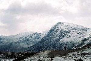
 Sgùrr na h-Ulaidh from Beinn Fhionnlaidh, with Bidean nam Bian and Stob Coire nam Beith (right) and Sgorr na Ciche (left) | |
| Highest point | |
| Elevation | 994 m (3,261 ft) [1] |
| Parent peak | Bidean nam Bian |
| Listing | Munro |
| Naming | |
| Translation | Peak of the Treasure (Scottish Gaelic) |
| Geography | |
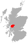
| Location | Glen Coe, Scotland |
| OS grid | NN111518 |
| Topo map | OS Landranger 41 and 50 |
| Climbing | |
| Easiest route | Hike |
Sgùrr na h-Ulaidh (also Sgòr na h-Ulaidh) ("Peak of the Treasure") is a mountain lying to the south of the village of Glencoe in the Scottish Highlands.[2] The mountain cannot be seen from the main A82 road as it is hidden behind Aonach Dubh a'Ghlinne.[3]
Ascent
The usual route of ascent is from Glen Coe, approximately 2 km west of Loch Achtriochtan.[3] A track on the west of Allt na Muidhe is followed and after 1 km the burn is crossed. The east side of the burn is then followed for about 3 km until a turn east is made to climb to the ridge just north of the top of Stob an Fhuarain. This peak is climbed, then the steep, rocky ridge is followed trending south-west to the summit of Sgùrr na h-Ulaidh.[3]
A route that avoids the steep ground on the north side of the mountain can be made from the southern Glen Etive side.[3]
References
- ↑ "walkhighlands Sgor na h-Ulaidh". walkhighlands.co.uk. 2013. Retrieved 9 November 2013.
- ↑ The spelling Sgùrr na h-Ulaidh (without the diacritic) is given in Ordnance Survey maps. Most other sources use the spelling Sgor na h-Ulaidh.
- 1 2 3 4 Bennet, Donald; Rab Anderson (eds) (2008). The Munros (3rd ed.). Scottish Mountaineering Club. p. 63. Cite uses deprecated parameter
|coauthors=(help)
 |
|  | |
Coordinates: 56°37′00″N 5°04′00″W / 56.61667°N 5.06667°W