Savigny-sur-Braye
| Savigny-sur-Braye | ||
|---|---|---|
|
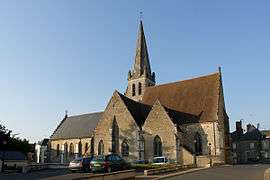
The church of Saint-Pierre, in Savigny sur Braye | ||
| ||
 Savigny-sur-Braye | ||
|
Location within Centre-Val de Loire region  Savigny-sur-Braye | ||
| Coordinates: 47°52′49″N 0°48′36″E / 47.8803°N 0.81°ECoordinates: 47°52′49″N 0°48′36″E / 47.8803°N 0.81°E | ||
| Country | France | |
| Region | Centre-Val de Loire | |
| Department | Loir-et-Cher | |
| Arrondissement | Vendôme | |
| Canton | Savigny-sur-Braye | |
| Intercommunality | Coteaux de la Braye | |
| Government | ||
| • Mayor (2001–2008) | Michel Saulière | |
| Area1 | 67.18 km2 (25.94 sq mi) | |
| Population (1999)2 | 2,203 | |
| • Density | 33/km2 (85/sq mi) | |
| Time zone | CET (UTC+1) | |
| • Summer (DST) | CEST (UTC+2) | |
| INSEE/Postal code | 41238 / 41360 | |
| Elevation |
74–166 m (243–545 ft) (avg. 87 m or 285 ft) | |
|
1 French Land Register data, which excludes lakes, ponds, glaciers > 1 km² (0.386 sq mi or 247 acres) and river estuaries. 2 Population without double counting: residents of multiple communes (e.g., students and military personnel) only counted once. | ||
.svg.png)
Savigny-sur-Braye is a commune in the Loir-et-Cher department of central France.
See also
| Wikimedia Commons has media related to Savigny-sur-Braye. |
This article is issued from Wikipedia - version of the 3/2/2015. The text is available under the Creative Commons Attribution/Share Alike but additional terms may apply for the media files.
