Santo Niño, Samar
| Santo Niño | |
|---|---|
| Municipality | |
| Nickname(s): formerly Limbancauayan | |
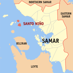 Map of Samar with Santo Niño highlighted | |
.svg.png) Santo Niño Location within the Philippines | |
| Coordinates: 11°56′20″N 124°25′10″E / 11.93889°N 124.41944°ECoordinates: 11°56′20″N 124°25′10″E / 11.93889°N 124.41944°E | |
| Country | Philippines |
| Region | Eastern Visayas (Region VIII) |
| Province | Samar |
| Congr. district | 1st district of Samar |
| Barangays | 13 |
| Government[1] | |
| • Mayor | Lilia A. Coñejos |
| Area[2] | |
| • Total | 29.53 km2 (11.40 sq mi) |
| ElevationCamandag Island | 429 m (1,407 ft) |
| Highest elevationSanto Niño Island | 470 m (1,540 ft) |
| Lowest elevation | 0 m (0 ft) |
| Population (2010)[3] | |
| • Total | 13,504 |
| • Density | 460/km2 (1,200/sq mi) |
| Time zone | PST (UTC+8) |
| ZIP code | 6711 |
| Dialing code | 55 |
Santo Niño is a fifth-class island-municipality in the province of Samar, Philippines. The town consists of the northern island of Camandag and the larger Santo Niño Island about 3.1 kilometers (1.9 mi) to the south. In between those two islands is the smaller Pilar Island.[4] The municipality's poblacion (town center) is located in Santo Niño Island. According to the 2010 census, the Municipality of Santo Niño has a population of 13,504 people with a total area of 29.53 square kilometers (11.40 sq mi).[3]
Geography
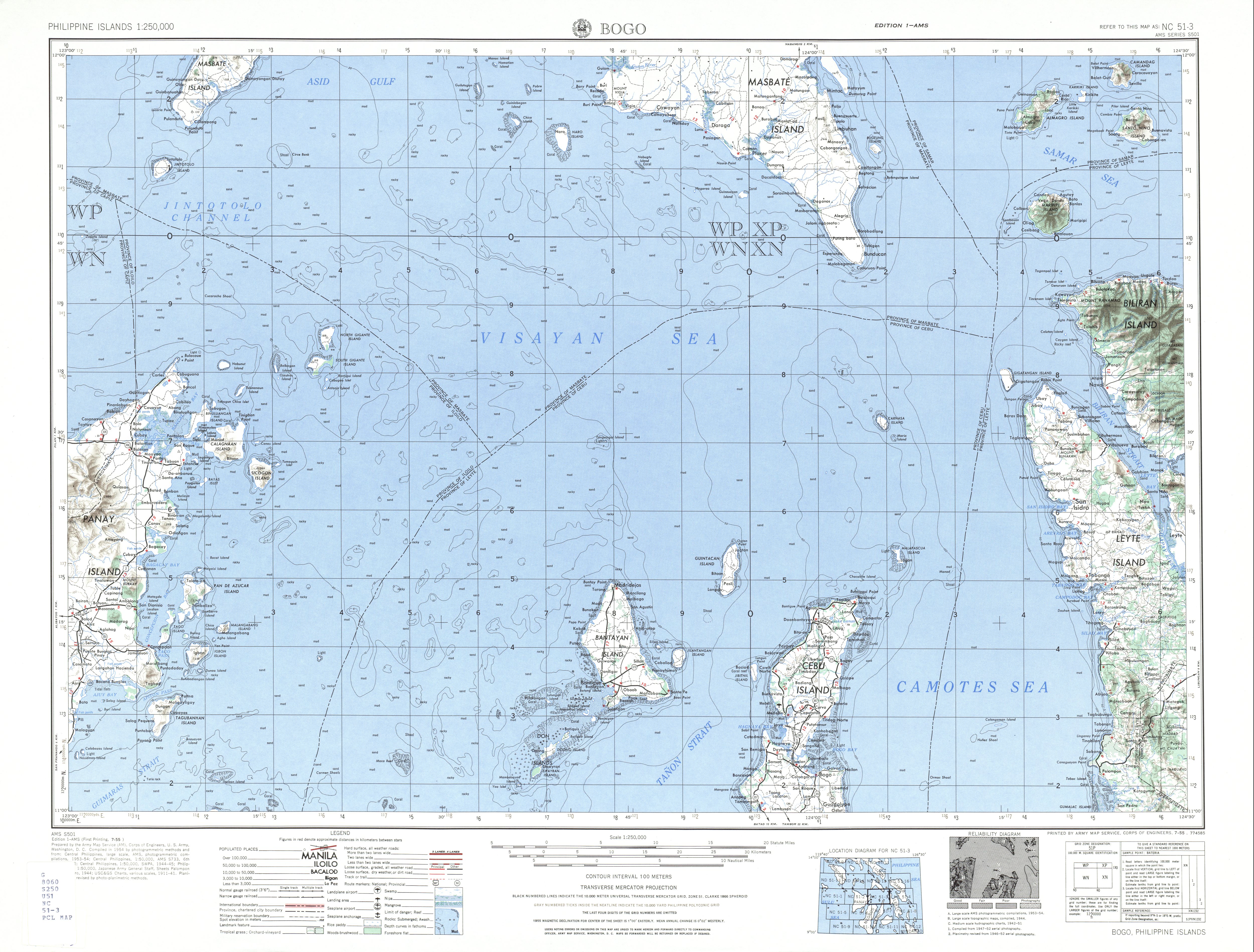
The islands are located in Samar Sea about 24 kilometers (15 mi) south-west of Calbayog City in the main island of Samar.
Santo Niño Island
The larger Santo Niño Island is about 18 kilometers (11 mi) north-west of Maripipi, Biliran province with an area of about 19.4 square kilometers (7.5 sq mi). Both islands are volcanic in origin with Santo Niño having the highest elevation in the municipality at 470 meters (1,540 ft).[5] [6]
Camandag Island
The circular Camandag Island is located north of Santo Niño Island, about 3.1 kilometers (1.9 mi) shore to shore. It has area of about 9.8 square kilometers (3.8 sq mi) with an elevation of 429 meters (1,407 ft).[5][7]
Pilar Island
The smallest island of the municipality is located 2.3 kilometers (1.4 mi) off north-west of Santo Niño Island and about 3.5 kilometers (2.2 mi) south-west of Camandag Island. Pilar Island has an elevation of 145 feet (44 m).[8]
Political subdivision
Santo Niño is politically subdivided into 13 barangays.[2]
Camandag Island
- Balatguti
- Corocawayan
- Lobelobe
- Pinanangnan (JMBere Coco+Cacao Farms)
- Sevilla
- Villahermosa
Santa
- Baras
- Basud (Pob.)
- Buenavista
- Cabunga-an
- Ilijan
- Ilo (Pob.)
- Takut
Population history
| Population census of Santo Niño | ||
|---|---|---|
| Year | Pop. | ±% p.a. |
| 1990 | 11,743 | — |
| 1995 | 12,761 | +1.57% |
| 2000 | 12,545 | −0.37% |
| 2007 | 12,777 | +0.25% |
| 2010 | 13,504 | +2.03% |
| Source: National Statistics Office[3][9] | ||
Accessibility
There are no airports on the islands of Santo Niño and Camandag. The islands are reached by boats from the Port of Calbayog City.[6]
See also
References
- ↑ "Municipalities". Quezon City, Philippines: Department of the Interior and Local Government. Retrieved 14 May 2013.
- 1 2 "Province: Samar (Western Samar)". PSGC Interactive. Makati City, Philippines: National Statistical Coordination Board. Retrieved 14 May 2013.
- 1 2 3 "Total Population by Province, City, Municipality and Barangay: as of May 1, 2010" (PDF). 2010 Census of Population and Housing. National Statistics Office. Retrieved 14 May 2013.
- ↑ "Pilar Island, Santo Niño, Philippines". Google Maps. Retrieved on 2013-11-10.
- 1 2 U.S. Army Corps of Engineer (1954). "Bogo (topographical map)". University of Austin Library. Retrieved on 2013-11-11.
- 1 2 Fabian, Galwin (2013-09-21). "Santo Niño Island in Samar". Intrepid Wanderer. Retrieved on 2013-11-11.
- ↑ Fabian, Galwin (2013-09-19). "Camandag Island in Samar". Intrepid Wanderer. Retrieved on 2013-11-11.
- ↑ U.S. Coast and Geodetic Survey (1919). "United States Coast Pilot, Philippine Islands, Part 1", pg. 205. Government Printing Office, Washington.
- ↑ "Province of Western Samar". Municipality Population Data. LWUA Research Division. Retrieved 21 August 2013.
External links
- Philippine Standard Geographic Code
- Philippine Census Information
- Local Governance Performance Management System
 |
Tagapul-an Samar Sea |
|
Calbayog Samar Sea |
|
| Almagro / Samar Sea | |
|||
| ||||
| | ||||
| Samar Sea Maripipi, Biliran |
|
Samar Sea |
Catbalogan (capital) | |
| Municipalities | |
| Component cities | |
