Sangu Matamuhari
| Sangu Matamuhari | |
|---|---|
|
IUCN category II (national park) | |
|
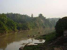
Forest by the river sangu | |
 | |
| Location | Bandarban District, Chittagong Division, Bangladesh |
| Coordinates | 21°41′22″N 92°10′01″E / 21.68944°N 92.16694°ECoordinates: 21°41′22″N 92°10′01″E / 21.68944°N 92.16694°E |
| Area | 23.32 km2 (9.00 sq mi) |
| Established | 2010 |
| Governing body | Bangladesh Forest Department |
Sangu Matamuhari or Sangu Wildlife Sanctuary is a wildlife sanctuary—IUCN category II (habitat/species management area)—situated in Bandarban District, Chittagong Division, Bangladesh. It is part of the Sangu reserve forest. It is under the Lama Forest Division of the Bangladesh Forest Department.[1][2] Its bio-ecological zone is in Chittagong Hills and Chittagong Hill Tracts.[3]
It houses Bangladesh's richest wildlife resource after Sunderbans. It is famous for its remoteness and for its rich array of wildlife, including great hornbills, crab-eating macaques, Asian elephants, sambar deer, Asian black bears, spotted owlets, leopards, clouded leopards, barking deer, Bengal monitors, dholes, and capped leaf monkeys/capped langurs. There have also been uncertain reports of vagrant tigers in the forest reserve by local indigenous people.[4]
It is a very remote and densely forested reserve. Thus the area remains largely undeveloped.[5]
Basic information
It was established in 2010; its total area is 2,332 hectares (5,760 acres).[3] It is under the Lama Forest Division of Bandarban. It is under the Sangu Forest Range. It is beside the Sangu River. Its physiography is categorized as Northern and Eastern Hills; its beat information is 285 Sangu Mouza. Visitors enter this wildlife sanctuary mostly for nature trails, picnic sites, etc. It has only one forest range office. It is a protected area under the wildlife act of 1974.

There are some Rohingya refugees in the area. Also, ethnic indigenous Mro people live around the forest area. It is situated in one of the most isolated parts of Bangladesh. Thus, it is not highly developed. It does not have correct boundary demarcations yet. There are some toilets and shops of local ethnic people in the sanctuary.[6]
Socio-economic context and threat assessment
The Wildlife Sanctuary does not provide any employment opportunity to the local people. The transport system is underdeveloped because of its remoteness. However, there are some private organization-conducted shops. Local ethnic people run the shops. 1200–1300 people depend on the wildlife sanctuary for resources like fuel wood, sun grass, bamboo, medicinal plant and others. There are some Rohingya refugee settlements around the forest.
Severe encroachment leading to expansion of settlements and agriculture, tree poaching, hunting, shooting, collection of fuel wood, bamboo and cane and other forest products are the major causes for the exploitation of resources of the national park. On the other hand, functioning sawmills in the vicinity and unemployment are the major underlying factors for the marked dependency of the local communities upon the park. Less stringent monitoring and a negative influence of some locally powerful individuals have further exacerbated the sustainable maintenance of the sanctuary.[6]
Ecological context and flora diversity
Sangu Matamuhari/ Sangu wildlife sanctuary is situated in Chittagong Hill Tracts area. The Chittagong Hill Tracts have been broadly classified as the tropical evergreen or semi-evergreen types, which, according to a source, supply around 40% of the commercial timber. The flora of the Chittagong Hill Tracts is distinctive in character and resembles the flora of Arakan. However, the teak patches that we see throughout the hill area are planted forests, not indigenous to the area.
Sangu River
Sangu River originates in the Arakan Hills of Myanmar and enters Bangladesh near Remarki (Thanchi upazila of Bandarban district). It flows north through Thanchi, Rowangchhari and Bandarban upazilas of Bandarban district. Then it flows west through Satkania and Banshkhali upazilas of Chittagong district to meet the Bay of Bengal near Khankhanabad (Chittagong). The length of the river is 295 km. The major tributaries of the river are Chandkhali Nadi and Dolu khal. There are 7 BWDB hydrometric stations on this river and data are available from 1965. Sangu River has its source at 21°13´N and 92°37´E in the North Arakan Hills.[7]
Flora
The wildlife sanctuary was once covered with luxuriant multi-storied evergreen forest. However, due to refugee settlements, the vegetation of these areas has diminished. Still it is quite rich in natural resources. And flora diversity is remarkable.

The most important commercial timber species of the Sangu Matamuhari is Jarul, Gamar, Garjan, Chapalish, Toon, Koroi, Civit, Champa, Simul, Chandul, etc. that used to grow to gigantic proportions. Most of the trees are of the evergreen type, whereas most of the tallest trees are deciduous and semi-deciduous. Some of the trees shed their leaves during the cold season and some in the summer, so the forest always looks green or, more correctly, the forest never loses its semi-evergreen appearance. However, this is a description of the forests of which remains roughly 70% of the area. As some portion of the forest reserves are well degraded than the past.[6]
Wildlife diversity
As the sanctuary is situated in very isolated area the wildlife of the sanctuary is comparatively better than most other national parks of Bangladesh. However, for the same reason its very unprotected. And hunting, poaching, illegal deforestation has become a common scene in the sanctuary due to the lack of management from forest department. Also the fauna data isn't well documented.[5]
Other than Sangu river there are some gorgeous looking small waterfalls all around the forest reserve. Some of the fish and amphibians found in the Sangu river are sawfish , butter fish , electric ray, common carp, silver carp, barb, river eels, starfish, king crab , fiddler crab, hermit crab, prawn etc.

The wide variety of plant life provides suitable habitats for 55 species of mammals including the capped leaf monkey and binturong, 286 species of birds like the hill myna, house swift and the greater painted-snipe; 56 species of reptiles and 13 species of amphibians. A limited number of Asian elephants live in the park. Common animals including reptiles and mammals are rhesus macaque , barking deer, Asian black bear, monitor lizard, Bengal monitor, etc. Golden jackals, fishing cats and dholes are common predators of the forest. There's few elusive clouded leopards too roaming inside the remoteness.
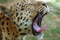
Indian leopard is very rare. However big cat pug marks supposed to be of leopard are occasionally found. Also there's one camera trapped pic of a leopard close to sangu wildlife sanctuary caught in 2015 proving its existence.[8]
The wildlife sanctuary was once covered with luxuriant multi-storied evergreen forest. The Asian elephant herds used to roam in and around the sanctuary. However, due to settlement of refuge, the vegetation of these areas diminished and became uninhabitable for elephants, which now can be seen in Sangu Mouza only.[6] Asian black bear is the most common bear species in the area but still low numbered. Second bear species of the area is Sun bear [9] Other large mammal sambar deer are also been reported here but in lower numbers. Just recent camera trap project captured some clouded leopard photos.[10] Endangered species great hornbill are still seen flying in the sanctuary. There are some spotted owlet as well.[11]
There are reports of tigers in the mixed evergreen hill tract valleys of Sangu-Matamuhuri, which are contiguous with forests in India and Myanmar respectively. Both of these sites are within an area classified as a Tiger Restoration Landscape, contiguous with the Northern Forest Complex-Namdapha-Royal Manas Global Priority Tiger Conservation Landscape (TCL).[12]
Nisharga Shahayata Prakalpa
Beside the National Forest Department, an NGO named "Nisharga", with their "Nisharga Shahayata Prakalpa", observes the park. Beside the preserving forest they provide eco-tours. Its forest type is mixed evergreen forest. In 2009 IPAC (Integrated Protected Area Co-management) project started its activities in this protected area.[6]
See also
References
- ↑ "Wildlife Sanctuary". Bangladesh Forest Department. 18 February 2015. Retrieved 28 December 2015.
- ↑ "Sangu Wildlife Sanctuary". ProtectedPlanet. 2014–2015. Retrieved 28 December 2015.
- 1 2 DeCosse, Philip J.; Thompson, Paul M.; Ahmad, Ishtiaq Uddin; Sharma, Ram A.; Mazumder, Azharul H., eds. (2012). "Protected Area Co-Management Where People and Poverty Intersect: Lessons from Nishorgo in Bangladesh" (PDF). Nishorgo Network. USAID.
- ↑ Hance, Jeremy (1 March 2016). "Tiger country? Scientists uncover wild surprises in tribal Bangladesh". The Guardian.
- 1 2 সূচীপএ : নিয়মিত বিভাগ. Shaptahik (in Bangla). 2009. Retrieved February 27, 2016.
- 1 2 3 4 5 International Resources Group (IRG) (28 February 2012). "Integrated Protected Area Co-Management (IPAC): State of Bangladesh's Forest Protected Areas 2010" (PDF). Nishorgo Network. USAID.
- ↑ Chowdhury, Sifatul Quader (2012). "Sangu River". In Islam, Sirajul; Jamal, Ahmed A. Banglapedia: National Encyclopedia of Bangladesh (Second ed.). Asiatic Society of Bangladesh.
- ↑ "Observations". iNaturalist.org.
- ↑ "Baseline Survey of Bears in Bangladesh 2008-2010" (PDF). International Association for Bear Research & Management. Wildlife Trust of Bangladesh. December 2010.
- ↑ "EcoGuardian Program Camera Trap Project".
- ↑ Chowdhury, Sayam U. (5 September 2014). "Going, going... gone!". The Daily Star. Retrieved February 27, 2016.
- ↑ Ahmad, I. U.; Greenwood, C. J.; Barlow, A. C. D.; Islam, M. A.; Hossain, A. N. M.; Khan, M. M. H.; Smith, J. L. D. (2009). Bangladesh Tiger Action Plan 2009-2017 (PDF). Dhaka: Bangladesh Forest Department, Ministry of Environment and Forests.
