Sangihe Islands Regency
| Sangihe Islands Regency Kabupaten Kepulauan Sangihe | |
|---|---|
| Regency | |
 | |
| Coordinates: 03°00′N 125°30′E / 3.000°N 125.500°ECoordinates: 03°00′N 125°30′E / 3.000°N 125.500°E | |
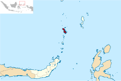
| Country | Indonesia |
| Province | North Sulawesi |
| Capital | Tahuna |
| Population (2010) | |
| • Total | 126,133 |
| Time zone | WITA (UTC+8) |
The Sangihe Islands Regency (Kabupaten Kepulauan Sangihe) is a regency of North Sulawesi Province, Indonesia. The principal island is also named Sangihe, on which lies the main town of Tahuna.
Administration
The Regency is divided into fifteen districts (kecamatan), tabulated below with their 2010 Census population.[1]
| Name | (English name) | Population Census 2010 |
|---|---|---|
| Manganitu Selatan | (South Manganitu) | 9,902 |
| Tatoareng | 4,358 | |
| Tamako | 12,991 | |
| Tabukan Selatan | (South Tabukan) | 5,860 |
| Tabukan Selatan Tengah | (South Central Tabukan) | 2,708 |
| Tabukan Selatan Tenggara | (Southeast Central Tabukan) | 2,107 |
| Tabukan Tengah | (Central Tabukan) | 10,217 |
| Manganitu | 13,904 | |
| Tahuna | 15,948 | |
| Tahuna Timur | (East Tahuna) | 12,377 |
| Tahuna Barat | (West Tahuna) | 5,943 |
| Tabukan Utara | (North Tabukan) | 2,919 |
| Nusa Tabukan | 2,919 | |
| Kepulauan Marore | (Marore Islands) | 1,371 |
| Kendahe | 6,463 |
Underwater vulcano
300 meter southeast of Mahangetang Island, there is Mahangetang Underwater vulcano with bubbles and hot water surrounding the peak which only 4 meters below the water when low-tide and 8 meters in high-tide.[2]
References
- ↑ Biro Pusat Statistik, Jakarta, 2011.
- ↑ "Kepulauan Sangihe". September 2, 2012.
| Wikimedia Commons has media related to Sangihe Islands. |
This article is issued from Wikipedia - version of the 10/7/2016. The text is available under the Creative Commons Attribution/Share Alike but additional terms may apply for the media files.
