Sanborn, Minnesota
| Sanborn, Minnesota | |
|---|---|
| City | |
 Cities and townships of Redwood County | |
| Coordinates: 44°12′33″N 95°7′44″W / 44.20917°N 95.12889°W | |
| Country | United States |
| State | Minnesota |
| County | Redwood |
| Area[1] | |
| • Total | 2.13 sq mi (5.52 km2) |
| • Land | 2.08 sq mi (5.39 km2) |
| • Water | 0.05 sq mi (0.13 km2) |
| Elevation | 1,099 ft (335 m) |
| Population (2010)[2] | |
| • Total | 339 |
| • Estimate (2012[3]) | 331 |
| • Density | 163.0/sq mi (62.9/km2) |
| Time zone | Central (CST) (UTC-6) |
| • Summer (DST) | CDT (UTC-5) |
| ZIP code | 56083 |
| Area code(s) | 507 |
| FIPS code | 27-58306[4] |
| GNIS feature ID | 0651130[5] |
| Website | www.cityofsanbornmn.org |
Sanborn is a city in Redwood County, Minnesota, United States. The population was 339 at the 2010 census.[6]
Geography

According to the United States Census Bureau, the city has a total area of 2.13 square miles (5.52 km2); 2.08 square miles (5.39 km2) is land and 0.05 square miles (0.13 km2) is water.[1] The Cottonwood River flows through the city.[7]
U.S. Highway 71 runs along the eastern edge of Sanborn, a short distance south of its intersection with U.S. Highway 14.[7]
Demographics
| Historical population | |||
|---|---|---|---|
| Census | Pop. | %± | |
| 1900 | 351 | — | |
| 1910 | 462 | 31.6% | |
| 1920 | 487 | 5.4% | |
| 1930 | 518 | 6.4% | |
| 1940 | 580 | 12.0% | |
| 1950 | 613 | 5.7% | |
| 1960 | 521 | −15.0% | |
| 1970 | 505 | −3.1% | |
| 1980 | 518 | 2.6% | |
| 1990 | 459 | −11.4% | |
| 2000 | 434 | −5.4% | |
| 2010 | 339 | −21.9% | |
| Est. 2015 | 318 | [8] | −6.2% |
2010 census
As of the census[2] of 2010, there were 339 people, 165 households, and 103 families residing in the city. The population density was 163.0 inhabitants per square mile (62.9/km2). There were 193 housing units at an average density of 92.8 per square mile (35.8/km2). The racial makeup of the city was 99.4% White and 0.6% from other races. Hispanic or Latino of any race were 3.2% of the population.
There were 165 households of which 19.4% had children under the age of 18 living with them, 50.3% were married couples living together, 7.9% had a female householder with no husband present, 4.2% had a male householder with no wife present, and 37.6% were non-families. 32.7% of all households were made up of individuals and 15.7% had someone living alone who was 65 years of age or older. The average household size was 2.05 and the average family size was 2.52.
The median age in the city was 47.7 years. 15.6% of residents were under the age of 18; 9.4% were between the ages of 18 and 24; 21.2% were from 25 to 44; 30.1% were from 45 to 64; and 23.6% were 65 years of age or older. The gender makeup of the city was 48.4% male and 51.6% female.
2000 census
As of the census[4] of 2000, there were 434 people, 179 households, and 127 families residing in the city. The population density was 203.8 people per square mile (78.7/km²). There were 199 housing units at an average density of 93.4 per square mile (36.1/km²). The racial makeup of the city was 99.08% White and 0.92% Native American. Hispanic or Latino of any race were 0.69% of the population.
There were 179 households out of which 31.8% had children under the age of 18 living with them, 60.9% were married couples living together, 6.1% had a female householder with no husband present, and 28.5% were non-families. 27.4% of all households were made up of individuals and 16.8% had someone living alone who was 65 years of age or older. The average household size was 2.42 and the average family size was 2.93.
In the city the population was spread out with 26.3% under the age of 18, 8.3% from 18 to 24, 21.2% from 25 to 44, 22.6% from 45 to 64, and 21.7% who were 65 years of age or older. The median age was 40 years. For every 100 females there were 100.0 males. For every 100 females age 18 and over, there were 102.5 males.
The median income for a household in the city was $36,375, and the median income for a family was $47,813. Males had a median income of $25,682 versus $21,016 for females. The per capita income for the city was $19,809. About 3.0% of families and 6.5% of the population were below the poverty line, including 4.2% of those under age 18 and 3.8% of those age 65 or over.
History
Sanborn was platted in 1881 and incorporated November 17, 1891.[10] It was named in honor of Sherburn Sanborn, who for many years was an officer of the Chicago and Northwestern railway company.[11] Sanborn post office was established May 17, 1880.[12]
References
- 1 2 "US Gazetteer files 2010". United States Census Bureau. Retrieved 2012-11-13.
- 1 2 "American FactFinder". United States Census Bureau. Retrieved 2012-11-13.
- ↑ "Population Estimates". United States Census Bureau. Retrieved 2013-05-28.
- 1 2 "American FactFinder". United States Census Bureau. Retrieved 2008-01-31.
- ↑ "US Board on Geographic Names". United States Geological Survey. 2007-10-25. Retrieved 2008-01-31.
- ↑ "2010 Census Redistricting Data (Public Law 94-171) Summary File". American FactFinder. United States Census Bureau. Retrieved 27 April 2011.
- 1 2 Minnesota Atlas & Gazetteer. Yarmouth, Me.: DeLorme. 1994. p. 30. ISBN 0-89933-222-6.
- ↑ "Annual Estimates of the Resident Population for Incorporated Places: April 1, 2010 to July 1, 2015". Retrieved July 2, 2016.
- ↑ "Census of Population and Housing". Census.gov. Retrieved June 4, 2015.
- ↑ Upham, Warren (1920). Minnesota Geographic Names: Their Origin and Historic Significance. Minnesota Historical Society. p. 452.
- ↑ Chicago and North Western Railway Company (1908). A History of the Origin of the Place Names Connected with the Chicago & North Western and Chicago, St. Paul, Minneapolis & Omaha Railways. p. 122.
- ↑ Patera, Alan H. and Gallagher, John S. (1978) The Post Offices of Minnesota, p. 154. Burtonsville, Maryland: The Depot.
External links
Coordinates: 44°12′35″N 95°07′43″W / 44.20972°N 95.12861°W
Municipalities and communities of Redwood County, Minnesota, United States | ||
|---|---|---|
| Cities | 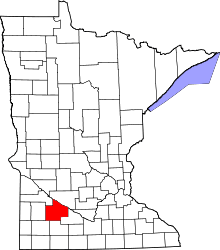 | |
| Townships | ||
| Unincorporated communities | ||
| Indian reservation | ||
| Footnotes | ‡This populated place also has portions in an adjacent county or counties | |