Saltdal Fjord
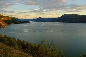
Saltdal Fjord[2][3][4][5] (Norwegian: Saltdalsfjorden) is a fjord arm of Skjerstad Fjord in the municipality of Saltdal in Nordland county, Norway. The fjord extends 11 kilometers (6.8 mi) south to Rognan at the bottom of the fjord.
The inlet of the fjord lies between Hjelbunes, a headland to the west, and Langruodden, a promontory to the east. The village of Setså lies on the east side of the fjord, slightly inland from the shore.[6] On the west lies the hamlet of Vik inside the bay formed by Tangodden, a peninsula jutting north into the fjord.[7] Rognan lies at the foot of the fjord,[1][8] and this is also where the Saltdal River flows into the fjord. West of the river's mouth lie the hamlets of Saksenvik and Botn.[8]
European route E6 runs along the entire east side of the fjord,[8] and Norwegian County Road 515 runs along the west side.
References
- 1 2 Douglas, John. 1972. The Arctic Highway: A Road and Its Setting. Newton Abbot: David and Charles, p. 45.
- ↑ Fitzgerald, Desmond J. L. 1949. History of the Irish Guards in the Second World War. Aldershot, UK: Gale & Polden, p. 54.
- ↑ Zetlitz Sømme, Axel Christian. 1949. Jordbrukets geografi i Norge, part 2. Bergen: J.W. Eide, p. 398.
- ↑ Buckley, Christopher. 1977. Norway: The Commandos. Dieppe. London: H.M. Stationery Office, p. 142.
- ↑ Plant, Terry. 1990. Nordic Journeys. Newton Abbot; Author, p. 123.
- ↑ Andrews, John T. 1974. Glacial Isostasy. Stroudsburg, PA: Dowden, Hutchinson & Ross, p. 226.
- ↑ Norges land og folk: Nordlands amt. 1908. Oslo: H. Aschehoug & Company, p. 250.
- 1 2 3 Philpott, Don. 1991. Visitor's Guide: Norway. Ashbourne: Moorland, p. 200.
Coordinates: 67°9′14.274″N 15°25′29.298″E / 67.15396500°N 15.42480500°E