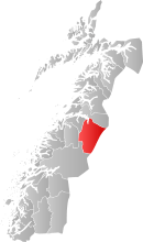
Saltdal
| Saltdal kommune | |||
|---|---|---|---|
| Municipality | |||
|
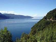
View of Saltdal | |||
| |||
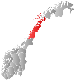
 Saltdal within Nordland | |||
| Coordinates: 66°55′12″N 15°33′36″E / 66.92000°N 15.56000°ECoordinates: 66°55′12″N 15°33′36″E / 66.92000°N 15.56000°E | |||
| Country | Norway | ||
| County | Nordland | ||
| District | Salten | ||
| Administrative centre | Rognan | ||
| Government | |||
| • Mayor (2011) | Finn Obert Bentsen (Ap) | ||
| Area | |||
| • Total | 2,216.16 km2 (855.66 sq mi) | ||
| • Land | 2,085.86 km2 (805.36 sq mi) | ||
| • Water | 130.30 km2 (50.31 sq mi) | ||
| Area rank | 23 in Norway | ||
| Population (2012) | |||
| • Total | 4,710 | ||
| • Rank | 197 in Norway | ||
| • Density | 2.25/km2 (5.8/sq mi) | ||
| • Change (10 years) | -3.1 % | ||
| Demonym(s) | Saltdaling[1] | ||
| Time zone | CET (UTC+1) | ||
| • Summer (DST) | CEST (UTC+2) | ||
| ISO 3166 code | NO-1840 | ||
| Official language form | Bokmål | ||
| Website |
www | ||
|
| |||
Saltdal (Northern Sami: Sálát) is a municipality in Nordland county, Norway. It is part of the traditional district of Salten. The administrative centre of the municipality is the village of Rognan. Other villages in Saltdal include Røkland and Lønsdal.
General information
The municipality of Saltdal was established on 1 January 1838 (see formannskapsdistrikt). In 1949, a small area of Skjerstad (population: 10) was transferred to Saltdal. Other than that one change, the borders have never changed.[2]
Name
The Old Norse form of the name must have been Salptardalr. The first element is the genitive case of the river name Salpt which means "strong steam", (now Saltdalselva, which runs through Saltdal) and the last element is dalr which means "valley" or "dale".[3]
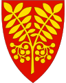
Coat-of-arms
The coat-of-arms is from modern times; they were granted in 1988. The arms show two gold-colored rowan twigs on a red background. It was chosen to represent nature and the prevalence of rowan forests in the municipality.[4]
Churches
The Church of Norway has two parishes (sokn) within the municipality of Saltdal. It is part of the Salten deanery in the Diocese of Sør-Hålogaland.
| Parish (Sokn) | Church Name | Location of the Church | Year Built |
|---|---|---|---|
| Saltdal | Saltdal Church | Rognan | 1862 |
| Øvre Saltdal | Øvre Saltdal Church | Røkland | 1938 |
History
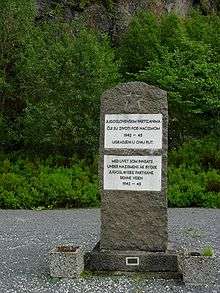
During World War II, the Germans decided to lengthen the Nordland Line from Lønsdal in Saltfjellet going northwards. Over a period of three years, the original plan was to first have both the road and the railroad all the way to Narvik and then on to Kirkenes, but they only managed to build the railroad to Bodø.
The Germans continued to lengthen the road to Kirkenes, and it came to be known as Blodvegen ("the Blood Road") by locals. This project involved prisoners of war, mostly from Yugoslavia and the Soviet Union, in building this road under extremely harsh conditions. The workers lived in prisoner camps where they did not receive enough food for the hard work with the road. This caused many of the workers to collapse and die. A famous sign of this road is the blood cross one of the prisoners drew on the mountainside with his recently killed friend's blood. It has become a tradition to repaint this cross with red paint, so people who pass this will never forget what happened. It's still possible to walk this road, which stretches from Saltnes to Soksenvika. At Saltnes, you will find the Blood Road museum.
Saltdal was known for having some of the most horrifying prisoner-of-war camps in Norway during World War II. A grand total of 15-18 camps with 9,500 Russian, Polish, and Yugoslavian prisoners were located in the valley.
Government
All municipalities in Norway, including Saltdal, are responsible for primary education (through 10th grade), outpatient health services, senior citizen services, unemployment and other social services, zoning, economic development, and municipal roads. The municipality is governed by a municipal council of elected representatives, which in turn elect a mayor.
Municipal council
The municipal council (Kommunestyre) of Saltdal is made up of 21 representatives that are elected to every four years. Currently, the party breakdown is as follows:[5]
| Party Name | Name in Norwegian | Number of representatives | |
|---|---|---|---|
| Labour Party | Arbeiderpartiet | 5 | |
| Progress Party | Fremskrittspartiet | 4 | |
| Conservative Party | Høyre | 4 | |
| Christian Democratic Party | Kristelig Folkeparti | 1 | |
| Centre Party | Senterpartiet | 3 | |
| Local Lists | Lokale lister | 4 | |
| Total number of members: | 21 | ||
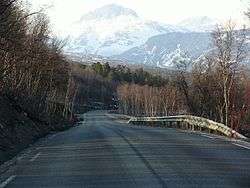
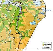
Geography

The main centre in the municipality is Rognan, on the southern shore of Saltdal Fjord, where the valley floor meets the fjord. When the Ice age ended and the ice had melted 9,000 years ago, the valley was a fjord as the sea reached what is today an elevation of 120 metres (390 ft) due to isostatic depression. The valley is situated just north of the Arctic Circle.
Two national parks are partially in the municipality: Saltfjellet–Svartisen National Park in the southwest, and Junkerdal National Park in the eastern part. This makes Saltdal one of the municipalities in Norway with the largest percentage of protected areas within its borders. The river Saltdalselva runs through the valley. The riverbed appears very bright in some places due to the minerals in the sand. The valley is covered with pine forest and birch and other trees are common as well. Lakes in the region include Balvatnet, Fiskeløysvatnet, Kjemåvatnet, and Nordre Bjøllåvatnet. The mountain Ørfjellet is also located in the municipality.
Climate
The municipality lies on the northeastern side of the Saltfjellet mountains, in the rain shadow of the mountains. With mountains surrounding it in almost all directions, Saltdal is one of the driest areas in Norway, especially the upper part of the valley. For five years in a row, 2001 to 2005, and then again in 2007 and 2008, the weather station in the upper part of the Saltdal valley recorded the least precipitation in all of continental Norway, with only 74 millimetres (2.9 in) in 2005. Average annual precipitation is 291 mm /year in the upper part of the valley.
Located in an inland valley, Saltdal is also known for its warm summer days, frequently being one of Norway's warmest locations if the right weather situation occurs (with easterly or southeasterly winds blowing). It is not uncommon with daytime temperatures approaching and sometimes exceeding 30 °C (86 °F) in the summer months. Similarly, winter temperatures can be quite cold, often dropping below −20 °C (−4 °F) on a clear day.
During a heatwave in June 2011, Saltdal recorded four days in a row with daytime temperatures exceeding 30 °C (86 °F). On 11 June 2011, Saltdal recorded a daytime high of 33.8 °C (92.8 °F), which was a new heat record for Nordland county in the month of June.[6]
Monthly 24-hr averages range from −6 °C (21 °F) in January to 14 °C (57 °F) in July (1961-1990 base period, source Norges Meteorologiske Institutt), and the annual average is 3.3 °C (37.9 °F). April and May are the driest months, with less than 10 millimetres (0.39 in) of precipitation. July is the wettest month with 39 millimetres (1.5 in). This data is from the driest, upper part of the valley, and many other parts of the municipality averages more than twice as much precipitation. Junkerdal (210 metres or 690 feet above sea level) averages 600 millimetres (24 in) annually.
| Climate data for Saltdal (10 last years) | |||||||||||||
|---|---|---|---|---|---|---|---|---|---|---|---|---|---|
| Month | Jan | Feb | Mar | Apr | May | Jun | Jul | Aug | Sep | Oct | Nov | Dec | Year |
| Average high °C (°F) | −2 (28) |
−2 (28) |
0 (32) |
6 (43) |
11 (52) |
16 (61) |
19 (66) |
17 (63) |
12 (54) |
6 (43) |
2 (36) |
−1 (30) |
7 (44.7) |
| Average low °C (°F) | −7 (19) |
−7 (19) |
−6 (21) |
0 (32) |
4 (39) |
8 (46) |
11 (52) |
10 (50) |
6 (43) |
1 (34) |
−3 (27) |
−5 (23) |
1 (33.8) |
| Source: [7] | |||||||||||||
Transportation
The European route E6 highway passes through the entire length of Saltdal, with the Nordland Line running alongside it. A road running east through the Junkerdalen valley (National Road 77) leads to Sweden. The nearest main airport is in Bodø, about 90 minutes from Rognan by road. There is a general aviation airport—Rognan Airport.
Economy
Saltdal has a great history in boat building out of local timber. Especially before World War II, the boatbuilding industry employed a large percentage of Saltdal's population.
Nowadays, the largest employer in Saltdal is Nexans. The company's Rognan factory specializes in telecommunication, fibre optics and copper cables. There is also some agriculture in Saltdal, and many people work within public services.
See also
- Blodveien ["The blood road"]
References
- ↑ "Navn på steder og personer: Innbyggjarnamn" (in Norwegian). Språkrådet. Retrieved 2015-12-01.
- ↑ Jukvam, Dag (1999). "Historisk oversikt over endringer i kommune- og fylkesinndelingen" (PDF) (in Norwegian). Statistisk sentralbyrå.
- ↑ Rygh, Oluf (1905). Norske gaardnavne: Nordlands amt (in Norwegian) (16 ed.). Kristiania, Norge: W. C. Fabritius & sønners bogtrikkeri. p. 228.
- ↑ Store norske leksikon. "Saltdal" (in Norwegian). Retrieved 28 March 2012.
- ↑ "Table: 04813: Members of the local councils, by party/electoral list at the Municipal Council election (M)" (in Norwegian). Statistics Norway. 2015.
- ↑ Saltdal/statistics.html
- ↑ "Saltdal average conditions - base period 10 last years". Storm Weather Center. Retrieved 8 December 2009.
External links
| Wikimedia Commons has media related to Saltdal. |
 Nordland travel guide from Wikivoyage
- Municipal fact sheet from Statistics Norway
- Junkerdal National Park
- Polarcircle center