Salley Historic District
|
Salley Historic District | |
 | |
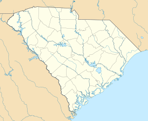  | |
| Location | Bounded by Pine, Ferguson, Poplar, and Aldrich Sts., Salley, South Carolina |
|---|---|
| Coordinates | 33°33′56″N 81°18′17″W / 33.56556°N 81.30472°WCoordinates: 33°33′56″N 81°18′17″W / 33.56556°N 81.30472°W |
| Area | 76 acres (31 ha) |
| Architectural style | Late Victorian, Bungalow/craftsman, et al. |
| NRHP Reference # | 00000554[1] |
| Added to NRHP | October 27, 2000 |
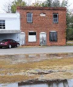
The Salley Historic District, located in Salley, South Carolina,[2][3] consists of 99 contributing structures and 51 non-contributing resources, and provides a good example of a South Carolina rural community during the late nineteenth and early twentieth centuries. The town, located in Aiken County, South Carolina and incorporated in 1887, is named after D. H. Salley, owner of a large nearby plantation who was instrumental in the area’s original development. The Salley Historic District was listed on the National Register of Historic Places on October 27, 2000.[1]
References
- 1 2 National Park Service (2010-07-09). "National Register Information System". National Register of Historic Places. National Park Service.
- ↑ Cerny, Jenny; Emily Garner; Carrie Herndon; Emily Peterson; Erin Shaw (July 6, 1999). "Salley Historic District" (pdf). National Register of Historic Places - Nomination and Inventory. Retrieved 28 November 2012.
- ↑ "Salley Historic District, Aiken County (bounded by Pine, Ferguson, Poplar & Aldrich Sts., Salley)". National Register Properties in South Carolina. South Carolina Department of Archives and History. Retrieved 28 November 2012.
| Topics |   | |
|---|---|---|
| Lists by county |
| |
| Lists by city | ||
| Other lists | ||
This article is issued from Wikipedia - version of the 11/29/2016. The text is available under the Creative Commons Attribution/Share Alike but additional terms may apply for the media files.