Rossville, Oklahoma
| Rossville | |
|---|---|
| Unincorporated community | |
 1905 map of Lincoln county showing the location of Rossville | |
 Rossville  Rossville Location within the state of Oklahoma | |
| Coordinates: 35°35′38″N 96°59′56″W / 35.59389°N 96.99889°WCoordinates: 35°35′38″N 96°59′56″W / 35.59389°N 96.99889°W | |
| Country | United States |
| State | Oklahoma |
| County | Lincoln |
| Time zone | Central (CST) (UTC-6) |
| • Summer (DST) | CDT (UTC-5) |
Rossville is a small rural community in Lincoln County, Oklahoma, on US Highway 177. The community had a post office from October 7, 1895, until February 15, 1907. Per Oklahoma Place Names it was named for Ross Thomas, a local resident.
The community consists of a store, a church, and several residential dwellings. The Rossville School was one mile south of the community and the Rossville cemetery is one mile south and a half-mile west of the community. Many of the buildings (including the store) were relocated back from the right-of-way when US 177 was constructed during the 1960s.
Sources
Shirk, George H.; Oklahoma Place Names; University of Oklahoma Press; Norman, Oklahoma; 1987: ISBN 0-8061-2028-2 .
Municipalities and communities of Lincoln County, Oklahoma, United States | ||
|---|---|---|
| Cities | 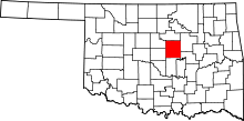 | |
| Towns | ||
| Unincorporated communities |
| |
| Ghost towns | ||
| Footnotes | ‡This populated place also has portions in an adjacent county or counties | |
This article is issued from Wikipedia - version of the 7/31/2016. The text is available under the Creative Commons Attribution/Share Alike but additional terms may apply for the media files.
