West Nyack, New York
| West Nyack, New York | |
|---|---|
| Census-designated place | |
 Location in Rockland County and the state of New York. | |
 West Nyack, New York Location within the state of New York | |
| Coordinates: 41°5′28″N 73°58′8″W / 41.09111°N 73.96889°WCoordinates: 41°5′28″N 73°58′8″W / 41.09111°N 73.96889°W | |
| Country | United States |
| State | New York |
| County | Rockland |
| Area | |
| • Total | 2.9 sq mi (7.5 km2) |
| • Land | 2.9 sq mi (7.5 km2) |
| • Water | 0.0 sq mi (0.0 km2) |
| Elevation | 79 ft (24 m) |
| Population (2010) | |
| • Total | 3,439 |
| • Density | 1,200/sq mi (460/km2) |
| Time zone | Eastern (EST) (UTC-5) |
| • Summer (DST) | EDT (UTC-4) |
| ZIP code | 10994 |
| Area code(s) | 845 |
| FIPS code | 36-80599[1] |
| GNIS feature ID | 0970831[2] |
West Nyack is a hamlet and census-designated place in the town of Clarkstown, Rockland County, New York, United States. It is located north of Blauvelt, east of Nanuet, southwest of Valley Cottage, southeast of Bardonia, and west of Central Nyack. It is approximately 18 miles (29 km) north of New York City. The population was 3,439 at the 2010 census.[3]
History
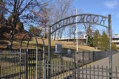
In 1847, the hamlet was named Clarksville, renamed MontMoor, and since 1891 has been known as West Nyack.

Geography
West Nyack is located at 41°5′28″N 73°58′8″W / 41.09111°N 73.96889°W (41.091096, -73.968785).[4]
According to the United States Census Bureau, the CDP has a total area of 2.9 square miles (7.5 km2), all land.
Demographics
As of the census[1] of 2000, there were 3,282 people, 1,107 households, and 892 families residing in the CDP. The population density was 1,125.9 per square mile (435.5/km²). There were 1,132 housing units at an average density of 388.3/sq mi (150.2/km²). The racial makeup of the CDP was 88.03% White, 1.98% African American, 0.03% Native American, 7.59% Asian, 0.98% from other races, and 1.40% from two or more races. Hispanic or Latino of any race were 5.58% of the population.
There were 1,107 households out of which 36.7% had children under the age of 18 living with them, 70.8% were married couples living together, 6.9% had a female householder with no husband present, and 19.4% were non-families. 14.2% of all households were made up of individuals and 6.1% had someone living alone who was 65 years of age or older. The average household size was 2.95 and the average family size was 3.27.
In the CDP the population was spread out with 23.8% under the age of 18, 5.7% from 18 to 24, 29.2% from 25 to 44, 27.5% from 45 to 64, and 13.8% who were 65 years of age or older. The median age was 40 years. For every 100 females there were 93.9 males. For every 100 females age 18 and over, there were 91.9 males.
The median income for a household in the CDP was $98,931, and the median income for a family was $106,576. Males had a median income of $67,326 versus $41,518 for females. The per capita income for the CDP was $40,178. About 1.0% of families and 2.6% of the population were below the poverty line, including 1.3% of those under age 18 and 5.2% of those age 65 or over.
Education
- Strawtown Elementary School became a Blue Ribbon Award winner in 2007. This is the second school in Rockland County to win this award.
- West Nyack Elementary School is located in West Nyack.
- Clarkstown High School South is located in West Nyack.
- Felix Festa Middle School is also located in Bardonia.
Historical markers
- Clarksville – West Nyack and Sickletown roads
- Clarksville Inn – 1 Strawtown Road. Built by Thomas Warner in 1840 as a hotel, the blacksmith shop still remains and is used as a retail shop. The Inn now serves as a restaurant, open for dinner seven evenings.
- Colonial Clarkstown – 135 Strawtown Road
- DeClark-Polhemus Mill – Intersection of Germonds, Strawtown & Old Mill roads
- Mount Moor African American Cemetery – Off Route 59 at West Nyack Road. "This: Burying ground for Colored people, was deeded on July 7, 1849 by James Benson and Jane Benson his wife to William H. Moor, Stephen Samuels and Isaac Williams, trustees. The cemetery has provided burial space for colored people, including veterans of the American Civil War, the Spanish–American War, World War I, World War II and the Korean War. The grounds have been maintained since 1940 by the Mount Moor Cemetery Association, Inc."
- Old Clarkstown Reformed Church Cemetery – 254 Germonds Road
- Pye's Corner – Strawtown and Germonds roads
- Site of First Reformed Protestant Dutch Church of New Hempstead – 254 Germonds Road
- The Nyack Turnpike – West Nyack Road and West Nyack Way
- The Old Parsonage – 106 Strawtown Road
- Van Houten Fields – In 1937 Ralph Borsodi organized a group for the purchase of a 106-acre Dutch farm divided into leased acreage plots, becoming the largest self-administered, back-to-the-land community in Rockland County.
- Washington's Encampment – 134 Strawtown Road
- West Nyack's Last Horse Trough, West Nyack Free Library – 65 Strawtown Road
- West Nyack's and New York's largest Shopping Center – Palisades Center Mall, Route 59. Tenth largest in the United States.
Landmarks and places of interest


- Palisades Center, one of the largest malls in the country, is located along Route 59, Route 303 and the New York State Thruway (I-87 and I-287), exit 12.
- Clarkstown Reformed Church – 107 Strawtown Road – Site of the First Reformed Protestant Dutch Church of New Hempstead (name in reference to many who moved here from Hempstead. L.I.). Built 1750–51, replaced 1871 by present Clarkstown Reformed Church, 107 Strawtown Road. Note gravestones inscribed in Dutch and those bearing names of 40 veterans of Revolutionary War and War of 1812 and of the Hill family, which produced three generations of artists and a renowned scientist.
- DeClark-Polhemus Mill – Remnants still exist on the southwest corner of Strawtown and Germonds roads, West Nyack. The last witchcraft trial in New York State supposedly took place at this gristmill in 1816. Jane (Naut) Kannif, a widow of a Scottish physician, was knowledgeable about herb medicines and was accused of practicing witchcraft. At the mill, Naut was weighed against a large brass-bound Dutch Bible on the large flour balance. Jane outweighed the Bible, was judged innocent and set free. The mill operated into the 20th century to grind flour. The hub of the water wheel still exists as does the dam and mill pond. Historical Marker on site.
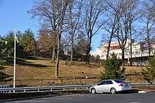
- Mount Moor Cemetery – Mount Moor Cemetery sits in the shadow of the Palisades Center Mall, just north of Route 59. This well-kept cemetery is maintained by the Mount Moor Cemetery Association of 1 Milford Lane, Suffern. Although several stones appear to have been professionally restored, many are too badly worn to read. There are also many field stones often used as burial markers with no inscriptions as well as a plain wooden cross. One of the graves at Mount Moor is that of Lafayette Logan, a Buffalo Soldier who fought in the American Civil War with the legendary black 54th Massachusetts Volunteer Infantry, the unit made famous in the motion picture Glory About six others members of the Buffalo Soldiers are buried here. (NRHP)
- Rockland Center for the Arts – Founded by Maxwell Anderson and others in 1947.[5][6] Programs include a School for the Arts, exhibitions, a performing arts series and a Summer Arts Day Camp. The Center provides opportunities for artists to exhibit, perform, create and teach.[7]
- Terneur-Hutton House – 160 Sickelton Road, National Register of Historic Places. (NRHP)
Solar field
Clarkstown is building a first-of-its-kind in New York State, a 2.3-megawatt solar system consisting of about 4,300 panels on top of a closed, highly regulated, flat shadeless 13-acre (5.3 ha) section of the former garbage landfill in West Nyack which will generate 3 million kilowatt-hours – enough power to supply about 200 homes, that will cover about one-third of the electric needs of the Town of Clarkstown government. The Clarkstown solar field project is at the maximum size that is allowed by New York State. Of the 1,200 installations in Orange and Rockland system, 450, or 32 percent, are in Rockland County and will save taxpayers as much as $4 million over 30 years by reducing the town’s annual electric bill – which is about $2 million – and produce 10 percent of all the electricity that O&R gets through solar power. This project was scheduled to be on line by fall 2014.[8]
Notable residents
- Adam Chanler-Berat, actor (Peter and the Starcatcher, Next to Normal)
- Jake T. Austin, actor (Wizards of Waverly Place)
- John Flaherty (born October 21, 1967), retired Major League Baseball player and current YES Network broadcaster
- John William Hill (1812–1879), British-born American artist. He was the son of John Hill who resided in West Nyack and was known as "Master of the Aquatint".
- Morris Kantor (1896–1974), Russian-born American painter
- Charles Wright Mills (August 28, 1916, Waco, Texas – March 20, 1962, West Nyack, New York), sociologist
- Michael Park (born July 20, 1968), Emmy Award-winning actor
- Arthur S. Tompkins (August 26, 1865 - January 20, 1938), U.S. Representative from New York and a justice of the New York Supreme Court
References
- 1 2 "American FactFinder". United States Census Bureau. Retrieved 2008-01-31.
- ↑ "US Board on Geographic Names". United States Geological Survey. 2007-10-25. Retrieved 2008-01-31.
- ↑ "Profile of General Population and Housing Characteristics: 2010 Demographic Profile Data (DP-1): West Nyack CDP, New York". U.S. Census Bureau, American Factfinder. Retrieved February 9, 2012.
- ↑ "US Gazetteer files: 2010, 2000, and 1990". United States Census Bureau. 2011-02-12. Retrieved 2011-04-23.
- ↑ "Rockland Center Plans 40th-Year Programs". New York Times. January 23, 1987.
- ↑ "Readings to Honor Maxwell Anderson". New York Times. May 20, 1988.
- ↑ "About us". Rockland Center for the Arts. Retrieved July 2, 2015.
- ↑ "Clarkstown Turns Old Landfill Into Solar Energy Field". 2014-07-08.
External links
- Clarkstown South High School
- National Registered Historic Places: Rockland County
- West Nyack Fire Department
- I Spy in West Nyack
Municipalities and communities of Rockland County, New York, United States | ||
|---|---|---|
| Towns | 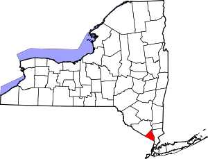 | |
| Villages | ||
| CDPs | ||
| Other hamlets | ||
